Abitibi greenstone belt
Tags: archean gabbro diorite gneiss granite greenstone belt neoarchean schist tonalit
Description:
Abitibi greenstone belt of the Superior province of the Canadian Shield. The area consists mostly of felsic to mafic volcanic rocks of Archean age together with related dioritic sills which are concordant to the regional rock formations. These volcanic and intrusive rocks have generally been metamorphosed to the greenschist facies.
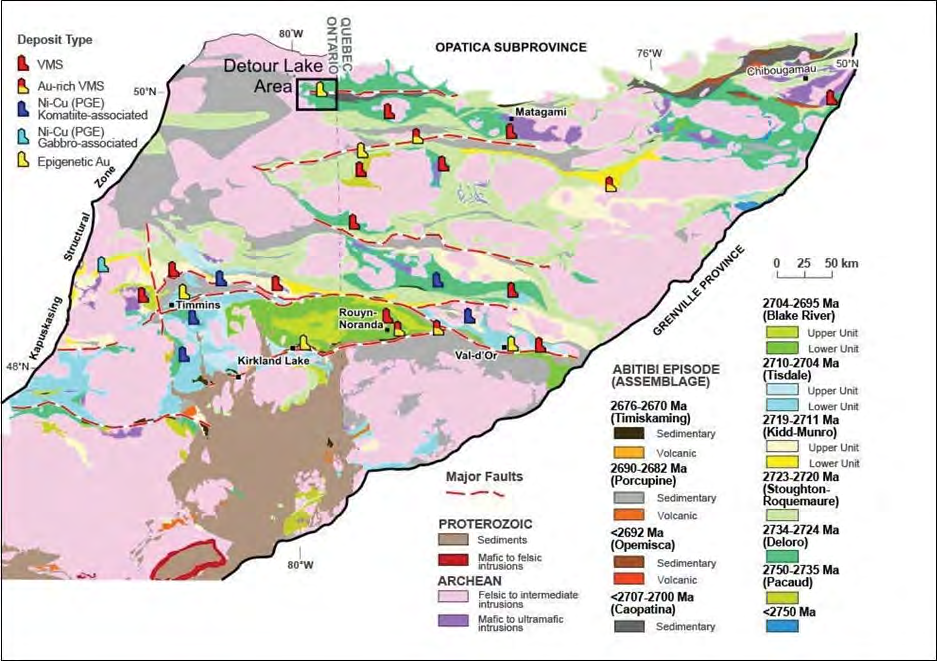
The Superior Province is the largest exposed Archean craton in the world and hosts several world class gold deposits. It has yielded nearly 300 million ounces of gold from hundreds of deposits since the beginning of the twentieth century. One prominent characteristic of all significant gold deposits in the Superior Province is their occurrence within or immediately adjacent to greenstone belts. Another characteristic is their occurrence within major tectonic zones which comprise a series of shear zones (Colvine et al., 1988). The Superior Province is divided into four major subprovince types (Card and Ciesielski, 1986): volcano-plutonic, plutonic, metasedimentary, and high metamorphic grade gneiss. The boundaries of these subprovinces are either major dextral, transcurrent, east-striking faults, or zones of structural and metamorphic transition.
The greenstone belts which host the gold deposits occur as east-north-easterly trending ribbon domains in the volcano-plutonic terrains. They typically consist of mafic to ultramafic and felsic metavolcanic rocks, interlayered with metasedimentary rocks. The supracrustal rocks were intruded by syn-volcanic plutons. Saturated and under saturated felsic to mafic igneous rocks intruded into the greenstone belts in late Archean.
The metamorphic grade of most of the present greenstone terrains ranges from sub-greenschist to greenschist facies in the centre, to lower amphibolite facies at the margin. Amphibolite facies contact metamorphic aureoles occur around intrusions into the greenstones (Jolly 1978, 1980) with the exception of the synvolcanic ones.
The Abitibi Greenstone Belt consists of east–west-trending synclines of felsic to ultramafic volcanic rocks. Intervening domes are cored by syn-volcanic tonalite and gabbro-diorite rocks and alternate with east–west-trending bands of late tectonic turbiditic and conglomeratic sedimentary rocks. Most of the volcanic and sedimentary strata dip vertically and are commonly bound by abrupt, east–west-trending faults with varied dips.
The stratigraphy of the Abitibi Greenstone Belt is subdivided into earlier volcanic-dominated episodes that include the Pacaud assemblage (2770–2736 Ma), the Deloro assemblage (2730–2724 Ma), the Stoughton-Roquemaure assemblage (2723–2720 Ma), the Kidd- Munro assemblage (2719–2711 Ma), the Tisdale assemblage (2710–2704 Ma), and the Blake River assemblage (2704–2695 Ma). These sequences are unconformably overlain by turbidites and calc-alkaline volcanic rocks of the Caopatina assemblage (ca. 2700 Ma) in the north and the Porcupine assemblage (2690–2685 Ma) in the south. These units in turn are unconformably overlain by coarse clastic and alkaline volcanic rocks of the Opemisca assemblage (ca. 2692 Ma) in the north and the Timiskaming assemblage (2676– 2670 Ma) in the south.
Berger (2002):
The Kidd-Munro assemblage underlies the north part of the study area and is composed of a tholeiitic metavolcanic member and a calc-alkalic metavolcanic member. Ultramafic to mafic layered sills intrude the metavolcanic rocks.
The Tisdale assemblage is composed of tholeiitic metavolcanic rocks and subordinate amounts of calc-alkalic metavolcanic rocks. The distribution of the assemblage is poorly constrained because of the Porcupine-Destor deformation zone and related splay faults transect the assemblage in several places.
The Kinojevis assemblage underlies the south part of the study area and is composed of predominantly mafic tholeiitic metavolcanic rocks that are intercalated with thin units of tholeiitic rhyolite and calcalkalic metavolcanic rocks.
The Porcupine assemblage underlies the northwest part of the study area and is composed of greywacke, argillite, and rare conglomerate that are intruded by small alkalic intrusions.
The Timiskaming assemblage is composed of clastic and chemical metasedimentary rocks and rare alkalic metavolcanic rocks that are distributed within and near to the Porcupine-Destor deformation zone. Ultramafic to felsic alkalic intrusive rocks are also correlated with the Timiskaming assemblage and occur as dikes, small single-phase intrusions and large multi-phase intrusions throughout the area. Paleoproterozoic quartz-diabase dikes, Keweenawan-age olivine diabase dikes and Jurassic kimberlite dikes and diatremes intrude the Neoarchean rocks.
The Porcupine-Destor deformation zone is a crustal-scale structure that transects the study area and is characterized by south-side-up vertical movement. The fault zone and related
northeast-striking splay faults such as the Ghostmount fault and McKenna fault, are the loci for gold mineralization. Northeast-striking faults with dominant vertical displacement transect the Porcupine-Destor deformation zone. Two of these faults, the Hislop fault and Garrison fault, are major structural features that act as the boundaries to different metallogenic segments. Gold mineralization occurs in different structural settings, different styles, and different types of alteration patterns in each segment.”
Deposits
-
Name: Kappa
Phase: Exploration
Mine Type: Underground
Intro:
Located in the Abitibi region, in the Bourlamaque and Louvicourt Townships, approximately 8 km southeast of the city of Val-dOr in the province of Quebec, Canada.
-
Name: Norlartic
Phase: Exploration
Mine Type: Pit, Underground
Intro:
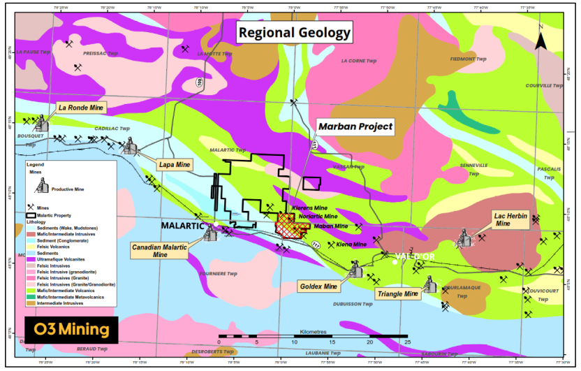
Canada, province of Quebec. The deposit is located in the western portion of the province, about midway between the towns of Val-d’Or and Malartic.
Located on the north side of Highway 117, approximately 15 km northwest of Val-d’Or, Quebec and immediately east of Canadian Malartic Partnership’s Camflo property. The project is accessible by the Gervais Road, a well-maintained all-weather gravel road running north from Highway 117. It provides access to the historic Norlartic, Kierens, and Marban mines. The Camflo road provides access to the western part of the project area. Winter access for snowmobiles and all-terrain vehicles is provided by trails and winter roads.
-
Name: Wasamac
Phase: None
Mine Type: None
Intro:
The Wasamac property is located approximately 15 km west-southwest of Rouyn-Noranda, Quebec, Canada, within the central portion of the Abitibi gold mining district. Rouyn-Noranda is serviced by daily flights to Montreal. The Property is accessed from Provincial Highway 117 that links Rouyn-Noranda and the community of Arntfield. A secondary road (Rang des Cavaliers) leads directly to the property from Provincial Highway 117.
-
Name: Marban
Phase: Exploration
Mine Type: Pit, Underground
Intro:
Canada, province of Quebec. The deposit is located in the western portion of the province, about midway between the towns of Val-d’Or and Malartic.
Located on the north side of Highway 117, approximately 15 km northwest of Val-d’Or, Quebec and immediately east of Canadian Malartic Partnership’s Camflo property. The project is accessible by the Gervais Road, a well-maintained all-weather gravel road running north from Highway 117. It provides access to the historic Norlartic, Kierens, and Marban mines. The Camflo road provides access to the western part of the project area. Winter access for snowmobiles and all-terrain vehicles is provided by trails and winter roads.
-
Name: Garrcon
Phase: Exploration
Mine Type: Pit, Underground
Intro:
Canada, Ontario. The Garrcon deposit is located approximately 40 km north of Kirkland Lake, Ontario, 40 km east of Matheson, and 100 km east of Timmins, Ontario. Air access to the area is available via scheduled commercial flights to Timmins. Direct highway access to the area from Toronto is via Highways 400 and 11 north through North Bay to Matheson (approximately 560 km), then east from Matheson along Highway 101. Highway 101 traverses the north side of the property and an 800-m long gravel road, constructed in 1988, allows for 2-wheel drive access to the property from the highway. Additional bush roads provide further local access into the property.
The Garrсon deposit is part of the so-called Garrison property, which also includes Jonpol and Zone 903.
-
Name: Jonpol
Phase: Exploration
Mine Type: Pit, Underground
Intro:
Canada, Ontario.
The Jonpol deposit is part of the so-called Garrison property, which also includes Garricon and Zone 903.
-
Name: 903 Zone
Phase: Exploration
Mine Type: Pit, Underground
Intro:
Canada, Ontario.
The 903 zone deposit is part of the so-called Garrison property, which also includes Garricon and Jonpol.
-
Name: Bulldog
Phase: Exploration
Mine Type: Underground
Intro:
Located in the Abitibi region, in the Bourlamaque and Louvicourt Townships, approximately 8 km southeast of the city of Val-dOr in the province of Quebec, Canada.
The data is taken from the description of Alpha property, which also includes the following objects: Kappa, Akasaba, Valdora, East Sullivan Rim, Magneto, Epsilon, Orenada Zone 2 and Zone 4, Simkar, Mid-Canada South and North.
-
Name: Detour Lake
Phase: Operations
Mine Type: Pit
Intro:
Canada, Ontario. From the town of Cochrane (population of approximately 5,000 residents), the Project is easily accessible by the Detour Lake Mine road, the northern extension of Highway 652. The first 151 km on Highway 652 is paved surface, followed by 34 km of well-maintained chipseal road to the mine site. Road access is available year-round. An airstrip built in 2021 provides access by air to the site. The closest major airport to the site is at Timmins, Ontario, approximately 61 km to the southeast.
Site topography is subdued with maximum local relief of approximately 30 m. The elevation ranges from approximately 260–288 metres above sea level. There is a pronounced north/south fluting of the landscape consistent with the general direction of the most recent glaciation in this area.
Areas of higher relief are sparsely wooded with jack pine, black and white spruce, balsam fir, trembling aspen, and white birch. Areas that are slightly lower in relief are poorly drained
and characterized by muskeg.There is very little bedrock outcrop and much of the Project area is overlain by thick accumulations of glacial material that includes till and glaciofluvial material (poorly sorted sand with lenses of gravel).
Numerous small streams linking elliptical lakes and ponds, generally oriented parallel to the pattern of glacial fluting. Numerous small and shallow lakes are found within the Project
area, the largest being Sunday Lake, with a surface area of approximately 2.8 km2. -
Name: West Detour
Phase: Development
Mine Type: Pit
Intro:
The Detour Lake deposit and the West-North Detour deposit, are a single mineral deposit. Description, maps, sections, resources and reserves see in the section Detour Lake.
-
Name: Zone 58N
Phase: Exploration
Mine Type: Underground
Intro:
Canada, Ontario. From the town of Cochrane (population of approximately 5,000 residents), the Project is easily accessible by the Detour Lake Mine road, the northern extension of Highway 652. The first 151 km on Highway 652 is paved surface, followed by 34 km of well-maintained chipseal road to the mine site. Road access is available year-round. An airstrip built in 2021 provides access by air to the site. The closest major airport to the site is at Timmins, Ontario, approximately 61 km to the southeast.
-
Name: Kierens
Phase: Exploration
Mine Type: Pit, Underground
Intro:
Canada, province of Quebec. The deposit is located in the western portion of the province, about midway between the towns of Val-d’Or and Malartic.
Located on the north side of Highway 117, approximately 15 km northwest of Val-d’Or, Quebec and immediately east of Canadian Malartic Partnership’s Camflo property. The project is accessible by the Gervais Road, a well-maintained all-weather gravel road running north from Highway 117. It provides access to the historic Norlartic, Kierens, and Marban mines. The Camflo road provides access to the western part of the project area. Winter access for snowmobiles and all-terrain vehicles is provided by trails and winter roads.
Mineralizations
No mineralizations available.
Placers
No placers available.