Bulldog
Phase: Exploration
Mine Type: Underground
Tags: alkaline andesite ankerite archean argillite basalt conglomerate dacite diorite dyke gabbro graphite greenstone belt greywacke komatite lava monzonite mudstone pluton pyrrhotite sandstone sericite sill stock tonalit tuff visible gold
Located in the Abitibi region, in the Bourlamaque and Louvicourt Townships, approximately 8 km southeast of the city of Val-dOr in the province of Quebec, Canada.
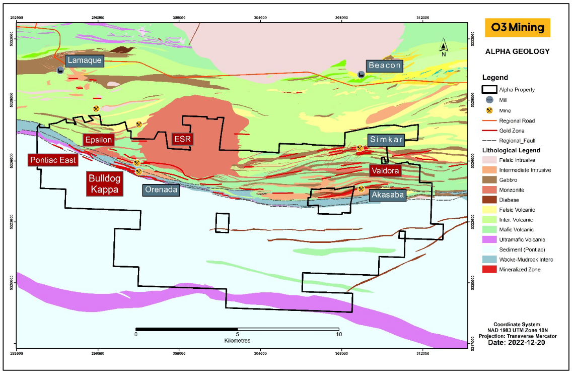
The data is taken from the description of Alpha property, which also includes the following objects: Kappa, Akasaba, Valdora, East Sullivan Rim, Magneto, Epsilon, Orenada Zone 2 and Zone 4, Simkar, Mid-Canada South and North.
History:
The deposit has a long history of exploration that started in the 1920s.
Regional geology: Abitibi greenstone belt
Abitibi greenstone belt of the Superior province of the Canadian Shield. The area consists mostly of felsic to mafic volcanic rocks of Archean age together with related dioritic sills which are concordant to the regional rock formations. These volcanic and intrusive rocks have generally been metamorphosed to the greenschist facies.
The Superior Province is the largest exposed Archean craton in the world and hosts several world class gold deposits. It has yielded nearly 300 million ounces of gold from hundreds of deposits since the beginning of the twentieth century. One prominent characteristic of all significant gold deposits in the Superior Province is their occurrence within or immediately adjacent to greenstone belts. Another characteristic is their occurrence within major tectonic zones which comprise a series of shear zones (Colvine et al., 1988). The Superior Province is divided into four major subprovince types (Card and Ciesielski, 1986): volcano-plutonic, plutonic, metasedimentary, and high metamorphic grade gneiss. The boundaries of these subprovinces are either major dextral, transcurrent, east-striking faults, or zones of structural and metamorphic transition.
The greenstone belts which host the gold deposits occur as east-north-easterly trending ribbon domains in the volcano-plutonic terrains. They typically consist of mafic to ultramafic and felsic metavolcanic …
Local geology:
The deposit is located at the junction of the Abitibi and Pontiac subprovinces and covers a 23 km long east-west segment of the Cadillac-Larder Lake Fault Zone in its eastern portion. Metasedimentary rocks of the Pontiac Subprovince dominate the southern half of the property, south of the Cadillac-Larder Lake Fault Zone. The Pontiac Subprovince sediments are composed of greywackes, siltstones, argillites, and a few conglomerate horizons.
The Piché and the Cadillac groups mark the contact of the Pontiac Subprovince sediments with the Southern Volcanic Zone of the Abitibi Subprovince to the north. The Cadillac-Larder Lake Fault Zone is coincident with the Piché Group, but also straddles the Cadillac Group and sometimes regionally overlaps the Pontiac Subprovince sediments. The Piché Group is highly deformed, with two distinct subparallel subunits that are laterally continuous. The northern subunit corresponds to an andesitic tuff, whereas the southern subunit corresponds to komatiite and komatiitic basalt flows. Both units are strongly deformed and exhibit schistose textures. Locally, spinifex textures have been identified in the southern ultramafic subunit. In the eastern part of the property, the location or the presence of the Piché Group remains unclear.
The Cadillac Group rocks on the property consist of greywacke, arenite, mudstone, and lenses of clast-supported, polymictic conglomerate. Thin interbeds (less than 1 m) of black, graphitic argillite are present. One interbed of graphitic sediments is regionally extensive, located near the contact between the Cadillac and Piché groups and is considered as a marker layer. This graphitic argillite contains up to 10-15% pyrite and pyrrhotite as disseminations and veinlets.
North of the Cadillac Group, the Louvicourt Group is represented by the Val-d'Or and the Héva Formations, two distinct volcanic cycles. The Val-d'Or Formation (2704-2705 Ma; Wong et al. 1991; Pilote et al. 1998) in contact with the Malartic Group, is composed of submarine lavas and volcaniclastics, mainly intermediate to mafic in the north and more intermediate towards the south. The volcanic rocks exhibit a transitional to calc-alkaline affinity (Desrochers et al., 1996). The younger Héva Formation (2702 ± 1 Ma; Pilote et al. 2000) contains mafic to intermediate volcanoclastics, pyroclastics and numerous dikes and syngenetic gabbro sills disturbing the small sedimentary levels. A horizon of spherulitic dacite characterizes the base all along the Héva Formation over 20 km (Scott et al., 2002).
Many intrusive rocks crosscut the volcanic or sedimentary rocks of the property. Within the Heva Formation, a series of gabbroic sills that form east-west trending elongated bodies sub-parallel to the stratigraphy. The most significant gabbroic sill is the Anamaque sill located immediately east of the East Sullivan pluton and runs up to the eastern limit of the property.
Located in the northern central part of the property, the East Sullivan intrusion (2684 ± 1 Ma; Pilote et al. 1999), is a composite circular stock (comprised of materials originally derived from two or more kinds of magma). The composite stock of calc-alkaline composition (Taner, 1996; Pilote et al., 2000) displays strongly altered porphyry phases of interpreted dioritic to monzonitic composition (Norman,1943; Assad, 1958). Many smaller dykes and plugs of similar composition and age are found within the volcanic rocks of the Louvicourt Group in the vicinity of the East Sullivan stock. To the east, monzonitic intrusions such as the Sabourin and Calahan plutons are found in the vicinity of the old Akasaba mine (Bigot, 2021).
Finally, Paleoproterozoic NE-SW diabase dikes record the youngest plutonic event in the district.
Deposit geology:
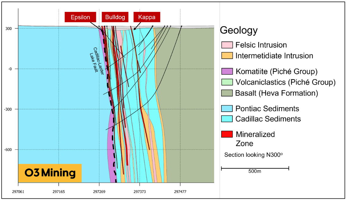
The Bulldog deposit is gold deposit hosted in the Cadillac sediments which dips steeply to the north-north-east at around 85° and forms a 75 m thick corridor located 55 to 130 m north of the Cadillac-Larder Lake Fault. The deposit is subdivided into three principal subparallel zones, Nord, Central and Sud. The zones range between 2 to 10 meters in thickness, are associated with strong shear zones that traverse the sediments and intrusive units. A close spatial association with tonalitic to dioritic planar intrusions suggests that mineralization is possibly intrusive-related. Generally, the Sud zone dyke is more dioritic in composition and demonstrates a greater increase in thickness with depth compared to the other two dykes. In each zone, gold mineralization is found in both the dykes and in the surrounding sediments.
The Bulldog deposit is characterized by very intense sericite and ankerite alteration. Both alteration styles extent up to 150 meters northward of the mineralized corridor into the hanging wall, Evidence of an earlier albitization footprint is occasionally preserved, though the later sericitization has generally overprinted the earlier alteration. The three zones are also strongly sheared with shear fabrics parallel orientation of the mineralized zones. As a result of the intense alteration and deformation, the dykes’ original textures often have been completely obliterated.
Near-surface, the higher gold values are generally encountered in the Sud zone while at depth the Nord zone becomes more dominant. In the main deposit, all three zones are consistently intercepted with drilling, with varying degrees of mineralization. Mineralization is primarily observed in the dykes as extremely fine -grained disseminated pyrite and as pyrite-pyrrhotite foliation-parallel stringers in the sediments. Rare molybdenum clusters are also found along shear planes. The dykes also contain 2-5% highly dismembered quartz veinlets which, very rarely, contain visible native gold. A strong relationship is observed between elevated gold grades and a combined presence of elevated alteration and deformation. The footwall of the Bulldog deposit is marked by a moderately sheared and altered unmineralized mafic volcanic unit that is a few metres thick.
Ore specimens:
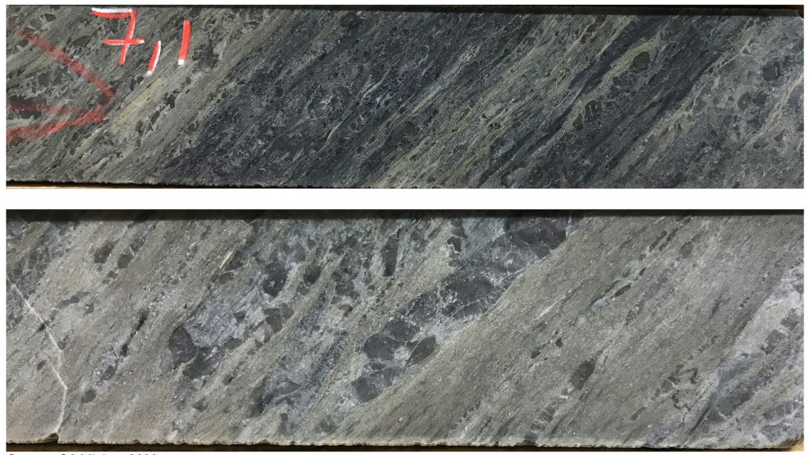
Typical Style of Mineralization at Bulldog
Deposit types:
The various mineralization styles present on the Alpha Property can be characterized as sub-types of the orogenic class of gold deposits, most commonly shear-zone hosted gold mineralization within greenstone terrains.
Greenstone-hosted quartz-carbonate vein deposits occur as quartz and quartz-carbonate veins, with valuable amounts of gold and silver in faults and shear zones located within deformed terrains of ancient to recent greenstone belts commonly metamorphosed at greenschist facies (Dubé and Gosselin, 2007). Greenstone-hosted quartz-carbonate vein deposits are a subtype of lode gold deposits (Poulsen et al., 2000). They are also known as mesothermal, orogenic. They consist of simple to complex networks of gold-bearing, laminated quartz-carbonate fault-fill veins in moderately to steeply dipping, compressional brittle-ductile shear zones and faults, with locally associated extensional veins and hydrothermal breccias.
In the case of the Alpha Property, two principal sub-types of orogenic gold mineralization have been identified. At Orenada, shear-hosted mineralization consisting of quartz–tourmaline–albite–carbonate veins and veinlets within mafic and intermediate rocks, with a low sulphide content (<2%) are present. Arsenopyrite abundance has a close association and correlation with gold mineralization. At Bulldog, mineralization is more associated with broader zones of deformation and alteration, with sericitization and fine disseminated pyrite the main indicators for gold mineralization hosted within the felsic dykes.
In addition to the typical shear zone-hosted gold mineralization, tonalite and granodioritic intrusions in the Malartic region can be prospective host units for mineralization and exhibit different alteration minerals due to the chemical interaction between mineralizing fluids and the host rocks. This type of mineralization tends to be associated with quartz–carbonate–tourmaline veins surrounded by albite alteration halos. They are very similar to the vein systems found at Sigma-Lamaque and Goldex mines in the Val-d’Or mining camp. The veins are spatially associated with discrete shears, but the veins itself are relatively undeformed.
Cu±Au±Mo skarn mineralization is dominant at both Akasaba and East Sullivan Rim and represents the more atypical examples of gold mineralization in the Val-d’or mining camp. Bigot (2021) identifies in his thesis a numbers of gold deposits surrounding the East Sullivan stock that exhibit Cu±Au±Mo affinities with high sulphide content and calc-silicate assemblages (Ca-amphibole, epidote, and carbonate ± magnetite). Garnets are also frequently noted, leading to the interpretation that the Akasaba and East Sullivan deposits can be potentially classified as skarn deposits and can co-exist with orogenic deposits such as Orenada and Bulldog.
Another example of an Archean Cu+Au skarn deposit is the Nevoria gold deposit in Southern Cross, Western Australia (Mueller, 1997).
Note:
Notes for mineral resources for the effective date 2022-11-10:
Underground Mineral Resources have been reported using a 1.8 g/t lower cut-off.
The Bulldog deposit has been classified as Inferred Mineral Resources according to drilling spacing and estimation pass. No Measured or Indicated Resources have been estimated. Underground Mineral Resources have been categorized manually to remove isolated areas not satisfying Reasonable Prospects of Eventual Economic Extraction (RPEEE) and have been reported using a 2 m minimum thickness.
The tonnages have been rounded to the nearest 1,000 tonnes and the metal content has been rounded to the nearest 1,000 ounces. Gold grades have been reported to one decimal place reflecting the uncertainty associated with Inferred Mineral Resources.
Notes from goldmap.info: the calculation of metric gold resources is conducted by multiplying the ore tonnage by the grade.
Mineral Resources (Nov. 10, 2022)
| Class | Ore (ktonnes) | Au grade (g/t) | Au (kg) | Au (oz * 1000) |
|---|---|---|---|---|
| Inferred | 2649.00 | 3.20 | 8476.80 | 270.00 |
Source:
-
NI 43-101 Technical Report Alpha Property Québec, Canada
(23.12.2022, Brossard)
Authors: Purchase James