Garrcon
Phase: Exploration
Mine Type: Pit, Underground
Tags: albite alkaline ankerite archean argillite arsenopyrite basalt breccia calcite carbonatization chalcopyrite chlorite conglomerate diabase dolomite dyke galena granite greenstone belt greywacke hematite komatite lamprophyre magnetite mariposite monzonite pyrrhotite sandstone schist sericite silicification siltstone specularite sphalerite stock stockwork syenite talc
Canada, Ontario. The Garrcon deposit is located approximately 40 km north of Kirkland Lake, Ontario, 40 km east of Matheson, and 100 km east of Timmins, Ontario. Air access to the area is available via scheduled commercial flights to Timmins. Direct highway access to the area from Toronto is via Highways 400 and 11 north through North Bay to Matheson (approximately 560 km), then east from Matheson along Highway 101. Highway 101 traverses the north side of the property and an 800-m long gravel road, constructed in 1988, allows for 2-wheel drive access to the property from the highway. Additional bush roads provide further local access into the property.
The Garrсon deposit is part of the so-called Garrison property, which also includes Jonpol and Zone 903.
History:
Exploration conducted on the property dates back to 1935 (Satterly, 1949). The mining claims that make up the property are patented and as a result very little of the exploration work carried out on the property has been filed with the government and the data are not in the government assessment work files.
Initial drilling on the property occurred in the period 1935 to 1946 on the historic Newfield, Garrcon, Brydges, Linton, Hastings and Wright-Hargreaves claim groups. Additional drilling was completed in 1983 by Long Lac Mineral Exploration Ltd. on the former Wright- Hargreaves claim L43903 (the 903 Zone) and by Kerr Addison Mines on the former Garrcon
claim group claims L26344 and L26343.
The most important historic data relating to the property are from the exploration work completed since 1985 by Jonpol Explorations Ltd. (and its partners Cominco, Lac Minerals and Hillsborough Resources), ValGold, Northern Gold and Osisko. The majority of work has concentrated on the Jonpol Deposit, Garrcon Deposit and the 903 Zone areas within the property. The true thickness of the mineralized zones identified from previous drilling are 60-95% of the sample lengths. Mineralization at the Garrcon deposit was previously interpreted to be striking approximately 075° and dipping 50° to the south; mineralization for Jonpol was previously interpreted to the sticking approximately 070° and dipping 75-85° to the south. Both mineralization models were used as a base for current interpretation.
Bath (1990) summarized the exploration and development from 1935 to 1989, for the area within and surrounding the present property. Squair (2000) further summarized exploration conducted up to 1997.
The exploration and development history from 1935 to 1988 has been extracted from Bath (1990) with metric equivalents inserted by Howe (2014):
1935: The Consolidated Mining and Smelting Company of Canada Ltd. optioned 9 claims from a Mr. McKenzie, sank a 256 foot (78 metre) deep inclined (to the south at 62 degrees)
shaft, performed about 1,033 feet (315 metres) of lateral exploration work on the 120 and 240 foot (36.5 and 73 metre) levels, and hoisted about 7,612 tons (6,920 tonnes) of waste material. By year end, about 10,550 feet (3,216 metres) of underground and surface diamond drilling had been completed (Young 1937, Sinclair et al. 1937, Sinclair et al. 1938).
1936: Garrcon Mines Ltd. was incorporated in May with Consolidated Mining and Smelting controlling the company and acting as operator on the Garrcon Mines property. 1,745 feet
(532 metres) of lateral underground exploration work and additional underground diamond drilling were completed (Sinclair et al. 1938).
1937: 4 feet (1.2 metres) of shaft sinking, 1,542 feet (470 metres) of lateral underground exploration work, 21 surface holes totaling 5,070 feet (1,545 metres), and 33 underground holes totaling about 5, 905 feet (1,800 metres) were diamond drilled. Before operations were suspended at year end, aggregate lateral underground exploration work amounted to 636 feet (194 metres) on the 120 foot (36.5 metre) and 3,655 feet (1,114 metres) on the 240 foot (73 metre) levels (Sinclair et al. 1939), aggregate diamond drilling totaled 16,099 feet (4,907 metres) (of which 11,029 feet (3,362 metres) were drilled underground) and about 520 feet (158 metres) of trenching had been completed (Satterly 1949).
1941: Consolidated Mining and Smelting diamond drilled one 293 foot (89 metre) hole near the northeast corner of claim 38950.
1946: Consolidated Mining and Smelting completed a magnetic survey.
1949: By this time, Consolidated Mining and Smelting controlled in addition to the Garrcon property, 3 contiguous patented claims to the west (claim Nos. 39949-51). Before 1949, trenching and 4 holes totaling 2,110 feet (643 metres) were diamond drilled on these claims (Satterly 1949).
1983: Kerr Addison Mines Ltd. diamond drilled 10 holes on the 12 Consolidated Mining and Smelting/Garrcon Mines (by this time, optioned by Cominco Ltd.) claims (Jonpol Explorations Ltd. 1987 Annual Report).
1985: Jonpol Explorations Ltd. acquired the right to earn a 49% interest in the 12 Cominco/Garrcon Mines claims.
1986: Diamond drilling by Cominco was financed by Jonpol Explorations and delineated 2 additional auriferous zones (the North and South Zones). These were described (The Northern Miner, February 10, 1986) to be stratabound and not vein type. By July, Jonpol had earned a 49% interest in the property (The Northern Miner, July 21, 1986). By September, the South Zone was reported (The Northern Miner, September 29, 1986) to be hosted by altered sediment, to average 6 feet (1.8 metres) in width, and to have been traced by diamond drilling to the (vertical) 500 foot (152 metre) level along about l,300 feet (396 metres) of strike. The North Zone had by this time been traced along strike for about 200 feet (61 metres), to the (vertical) 500 foot (152 metre) level, averaged 10.7 feet (3.3 metres) in width, and was reported to be hosted by a wide shear.
1987: By midyear, drilling funded by Jonpol Explorations and supervised by Cominco had established reserves of 1.5 million tons (1.36 million tonnes) of material averaging 0.04 ounce
of gold per ton (1.37 grams gold per tonne) above the 200 foot (61 metre) level near the shaft. The South Zone was indicated to average 0.15 ounce of gold per ton (5.14 grams gold per tonne) across 3.8 feet (1.2 metres) along l,400 feet (427 metres) of strike. The North Zone was reported to have been drill defined along 300 feet (91 metres) of strike. A new auriferous zone within the "Munro Shear" was reported to average 10 feet (3 metres) in width, to be drill defined along 250 feet (76 metres) of strike, with a mineralized drill core length of 36.9 feet (11.3 metres) averaging 0.30 (cut) ounce of gold per ton (10.28 grams gold per tonne - cut) intersected within it (Jonpol Explorations Ltd. 1987 Annual Report). By July, Jonpol Explorations/Cominco were reported (The Northern Miner, July 27, 1987) to have spent $500,000 and that an additional $2 million was budgeted for additional exploration during the next 2 years.
1988: Jonpol Explorations announced in a news release dated February 2, 1988 that aggregate drill defined reserves were estimated to be 350,900 tons (319,000 tonnes) of material
averaging 0.191 ounce of gold per ton (6.55 grams gold per tonne) above the (vertical) 500 foot (152 metre) level in three distinct zones. Later, Jonpol Explorations acquired a 100% interest in the property following Cominco’s having diamond drilled 79 holes totaling about 70,168 feet (21,387 metres) since 1983 (A. D. Drummond, project engineer, Jonpol Explorations Ltd. , pers. comm. 1988). In July, Lac Minerals Ltd. obtained the right to acquire a 50% interest in the (Jonpol Explorations) properties (The Kirkland Lake Northern Daily News, July 7, 1988; The Northern Miner, July 11, 1988), and in November, Lac Minerals optioned the property (The Northern Miner, November 21, 1988).
1991: The Lac Minerals agreement was terminated.
2006 to 2009: ValGold completed 3 BQ-sized and 11 NQ-sized diamond drill holes on the Garrcon Zone totalling 5,709 m.
2009 to 2015: Starting in 2009 Northern Gold completed a variety of exploration work on the property, focused on Garrcon, including diamond drilling, geophysical surveys, metallurgical work, surface sampling, hyperspectral core mapping, and a bulk sample.
2009: Satellite imagery covering 25 square kilometre area over the entire Garrison Property. Due diligence review of the ValGold data to identify errors and omissions. 11 NQ diamond drill holes on the Garrcon Deposit totalling 2,330 m.
2010:
- Garrcon drill hole collar survey: Between January 26 and May 30, 2010, Northern Gold utilized a differential global positioning system (DGPS) to identify multiple drill holes and historical grid lines on the “Cominco Grid” and reposition these holes and grid lines to fit the ground-truthed model. The overall repositioning resulted in a roughly 10 m shift to the west for all “Cominco Grid” drill holes.
- Garrison rehabilitation: Construction of new core storage pads, purchase of new storage racks as well as expansion of core shack building.
- Garrcon surface stripping/sampling: A total of four areas were stripped of overburden with an excavator and washed using a Wajax fire pump. The total surface area exposed in all four areas is roughly 5,000 m2. The stripped areas focused on multiple high-grade veins found east of the core shack along the Garrcon Shaft Zone. 150 m of channel samples were cut on the newly exposed outcrops.
- Garrcon metallurgical Testing: Northern Gold submitted two composite samples of Garrcon mineralization to SGS Mineral Services of Lakefield, Ontario for preliminary metallurgical test work.
- Garrcon petrographic study: Northern Gold submitted fourteen drill core samples for petrographic study in 2010, in order to classify the rock types on the property based on petrographic textures.
2010 and 2013: Garrison surface grid and magnetics/VLF EM geophysics.
2010 to 2014: Garrison Environmental Baseline Study/Permitting.
2011 to 2014 Environmental baseline study/permitting: Activities included water quality sampling of the creeks, profile water sampling of the Jonpol vertical shaft and rock dump sampling at Jonpol for acid rock drainage (ARD) and metal leaching analyses. In 2013 Northern Gold began working on an advanced exploration closure plan for a bulk sample on the Garrcon Deposit.
2011: Garrison IP geophysical survey. Garrcon surface stripping / sampling - Northern Gold continued a surface stripping program in the Garrcon Deposit area in 2011. A total of five areas were stripped of overburden with an excavator and washed using a Wajax fire pump.
2011 In 2011, A.C.A. Howe reviewed the Garrcon Deposit at the level of a Preliminary Economic Assessment (PEA) (Hannon et al., 2011).
2011 to 2012 Hyperspectral core mapping: In 2011, 4,900 m of Garrcon core was mapped using a Core MapperTM hyperspectral imaging system and a project specific spectral library was generated.
2012 Garrison structural mapping: Terrane Geoscience Inc. was contracted to conduct mapping and an initial structural analysis on the Garrison Property from October 10 to 21, 2012. The JP Zone was interpreted to occur in a possible trans-tensional zone (southward jog) related to D3 left lateral movement along the Munro Fault Zone potentially representing a dilational zone that acted as a control on gold mineralization. In the Garrcon area, the majority of the visible gold observed occurs in the (VJ2) flat lying extensional vein set. Pyrite enrichment in the axial planes of F3 folds was observed.
2010, 2011 and 2012 Garrcon diamond drill programs: Northern Gold’s 2010, 2011 and 2012 Garrcon diamond drill programs focused on in-fill drilling and expanding the Garrcon Deposit mineral resource. A total of 91,493.1 m were drilled in 269 drill holes.
2013 Hastings Zone exploration: Northern Gold focused on surface mapping, grab sampling, surface stripping and channel sampling on the Hastings Property. Three outcrops totalling 2,802 m2 in area were stripped and channel sampled.
2013 to 2014 Garrcon metallurgical testing: In late 2013, Northern Gold submitted a composite drill core sample from the Garrcon Deposit to Kappes, Cassiday & Associates of Reno, Nevada for preliminary column leach testing of 100% minus 9.5 mm crushed material.
2014 to 2015 Bulk Sample Program: In 2014 and 2015, Northern Gold obtained a trial production mining permit through the MNDM, allowing for the extraction of up to 150,000 tonnes. Commencing in 2014, Northern Gold ultimately mined 73,534 dry tonnes which was processed at the nearby Holt mill facility, recovering 3,516.3 ounces at a calculated average head grade of 1.55 g/t Au and recovery of 95.69%.
2014. Prior to initiating the bulk sample in 2014, a definition drilling program was undertaken by Northern Gold, utilizing a blast hole drill, to better define the mineralized zones previously encountered in diamond drilling. The company reports that the nominal spacing of diamond drill holes in the area of the bulk sample was 25 m and this was deemed insufficient for pit design in order to optimize recovery of mineralized material. The definition drilling program utilized the same percussion blast hole drill that was later utilized in the open pit production drilling. At times two drill rigs were operating to complete the work. The drilling program was conducted on a nominal 5 x 5 m grid utilizing a 3.5-inch percussion blast hole. Holes were drilled to a nominal 20 m depth, the rod capacity of the drilling rig. Northern Gold reports that each drill rig was equipped with a cutting recovery vacuum and dust collector system. Each drill hole was paused at 1.0-m intervals to allow for discreet sample collection over that distance. Workers used 5-gallon pails to collect as much of the sample as possible from both the coarse cutting collector and dust collector. The coarse and fine material was then moved to a sample processing shack and weighed to estimate a percentage recovery for each sample based on its sample length and estimated total mass. Then, utilizing a 3‐tier jones-type splitter workers would reduce the overall mass of the sample to approximately 2 to 3 kg to be prepared for assaying. At roughly every 40 samples, 2 splits would be taken as a coarse field duplicate to be referenced for quality assurance/quality control (QA/QC) purposes. For each sample a small (~50 g) sample of rock chips was retained for geologic reference purposes. The average sample recovery was calculated to be 93% for definition drill samples. After comparison with results from the neighbouring diamond drill holes it was decided to use these samples in the mineral resource estimate. The production blast holes were not used as they were sampled over much wider intervals and resulted in much poorer recoveries.
Regional geology: Abitibi greenstone belt
Abitibi greenstone belt of the Superior province of the Canadian Shield. The area consists mostly of felsic to mafic volcanic rocks of Archean age together with related dioritic sills which are concordant to the regional rock formations. These volcanic and intrusive rocks have generally been metamorphosed to the greenschist facies.
The Superior Province is the largest exposed Archean craton in the world and hosts several world class gold deposits. It has yielded nearly 300 million ounces of gold from hundreds of deposits since the beginning of the twentieth century. One prominent characteristic of all significant gold deposits in the Superior Province is their occurrence within or immediately adjacent to greenstone belts. Another characteristic is their occurrence within major tectonic zones which comprise a series of shear zones (Colvine et al., 1988). The Superior Province is divided into four major subprovince types (Card and Ciesielski, 1986): volcano-plutonic, plutonic, metasedimentary, and high metamorphic grade gneiss. The boundaries of these subprovinces are either major dextral, transcurrent, east-striking faults, or zones of structural and metamorphic transition.
The greenstone belts which host the gold deposits occur as east-north-easterly trending ribbon domains in the volcano-plutonic terrains. They typically consist of mafic to ultramafic and felsic metavolcanic …
Local geology:
Satterly (1949) mapped Garrison Township for the Ontario Department of Mines and his mapping provides the best geological work relating to the geology of the property. Berger (2002) made minor amendments to the geology and brought the nomenclature for the various volcanic-sedimentary units up-to-date in terms of the current understanding of the stratigraphy of the Abitibi Greenstone Belt.
The property is underlain by rocks of the Kidd-Munro and Timiskaming Assemblages and about 4 km of the regionally significant Destor-Porcupine Fault Zone and a major splay, the
Munro Fault Zone. Both fault zones comprise a variably altered and deformed sequence of metavolcanic rocks that include komatiites and tholeiitic basalts.
The Kidd-Munro Assemblage is comprised of massive to pillowed, mafic (high magnesium and iron tholeiites) and ultramafic (komatiite) metavolcanic rocks. The metavolcanic flows strike in a general east-west direction and dip steeply to the south. However, outcrop is limited and there is probably significant local folding, particularly in the vicinity of the major fault zones that cross the property. No surface exposures of ultramafic (komatiitic) metavolcanics have been identified, however, in drill core there are abundant occurrences of talc schists, talc-carbonate schists, and carbonate-mariposite schists that are indicative of the presence of ultramafic or high magnesium tholeiites in the metavolcanic sequence. It is a clear possibility that the Munro and Porcupine-Destor faults are focused within the ultramafic rock units because of their high ductility compared to the more brittle mafic metavolcanic, felsic metavolcanic and metasedimentary assemblages. The Munro fault hosts the Jonpol Deposit.
The Timiskaming Assemblage is composed of clastic metasedimentary rocks, consisting of conglomerate, wacke-sandstone, siltstone, argillite and schist, and is closely associated with the Porcupine-Destor deformation zone from the Quebec border to Hislop Township, a distance of approximately 65 km (Berger, 2002). Banded magnetite-hematite iron formation is complexly interbedded and structurally interleaved with clastic metasedimentary rocks.
The Timiskaming Assemblage is younger than the Kidd-Munro Assemblage and, in the absence of faults the contact between the assemblages is an angular unconformity. On the property, the Timiskaming Assemblage is fault bounded, on the north side by the Munro fault and on the south side by the Porcupine-Destor fault. The metasedimentary beds strike in a general east-west direction and dip steeply to the south. In general, along the Munro fault zone the bedding tops are facing to the north, whereas to the south, along the Porcupine-Destor Fault Zone, the bedding tops are facing to the south. The Timiskaming metasediments host the Garrcon Deposit immediately north of the Porcupine-Destor fault, and to the east of the Garrison fault.
The Timiskaming Assemblage to the west of the Garrison fault hosts three magmatic groups: syenites, lamprophyres, and diabases in albite-sericite-chlorite altered ultramafic to mafic volcanics. The syenites are likely associated with the Timiskaming magmatic event, recognized along the Abitibi as having occurred approximately between 2680 and 2672 Ma (Corfu et al, 2001) and alteration is primarily albite-hematite-specularite.
Immediately to the south of the property is a large, metamorphosed, alkalic intrusive stock with a plan view diameter of 4 to 4.5 km. The intrusive varies in composition from granite to monzonite.

Deposit geology:
The Garrcon Deposit, comprises a broad zone of low-grade gold mineralization that includes local higher-grade areas. It occurs within the Timiskaming Assemblage adjacent and to and north of the Porcupine-Destor fault and to the east of the north-south trending Garrison fault. It is a zone of brecciated, silicified metasediments with stockwork type quartz-carbonate veins and veinlets and minor disseminated sulphides cut by narrow variably altered lamprophyre and syenite dikes.
Gold mineralization in the Garrcon metasedimentary zones is hosted by Timiskaming-age metasedimentary rock sequences that include greywacke, arkose and iron formation cut by
narrow lamprophyre and syenite dikes, occurring adjacent to the Destor-Porcupine Fault Zone. These metasedimentary sequences have been hydrothermally altered and mineralized in distinct zones persisting to depths greater than 650 m vertically. The intrusive dikes are variably altered. Gold occurs in a complex system of stockwork veins hosted in a zone of brecciated and silicified metasediments.
The sedimentary package shows little variation, mainly including fine to coarse-grained sandstones as well as minor mudstone layers. The veins are composed predominately of quartz-carbonate (calcite, dolomite and ankerite) with and without albite. The stockwork veins are normally less than one centimetre in width with many being only a half centimetre wide or less.
Development and mining at the Garrcon Shaft Zone began in 1935 with the sinking of a 256 ft (78 m) deep shaft by Consolidated Mining and Smelting Company of Canada Ltd. In 1986, diamond drilling by Cominco Ltd. delineated two new auriferous zones (the North and South Zones) which were described as "stratabound". The South Zone was reported to be hosted by altered sedimentary rocks, with mineralization averaging 1.8 m in width, and traced by diamond drilling to 500 ft (152 m) vertical along 396 m of strike length. The South Zone is described by Bath (1990) as striking 75°, dipping south at 50° and within about 21 m of and/or within a regional scale, east-striking and steeply dipping shear developed between clastic sedimentary rocks to the north and komatiitic rocks to the south. The North Zone was reported to be hosted in a shear zone, and had been traced along strike for about 61 m, down to 152 m in the vertical, and averaged 3.3 m in width.
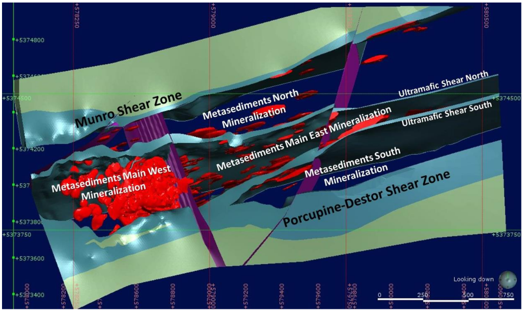
RockRidge’s deposit model for the 2019 resource estimate was developed around a pervasive metasedimentary unit located between the Munro and Porcupine-Destor fault zones and to the east of the Garrison fault. Mineralized domains bounded by faults lie within a broad zone of high and lower grade mineralization that extends over an east-west distance of 2,400 m. The deposit was split into four zones of mineralization within the metasedimentary units.
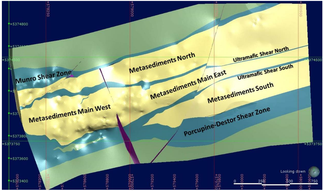
Combined, the mineralization within the metasedimentary units averages approximately 400 m in width, with the narrowest widths located on the more sparsely drilled eastern end of the zone. A maximum width of 580 m occurs in the more densely drilled western portion. Two distinct shear zones split the metasedimentary rocks into North, Main and South units, while a north-south fault, parallel to the Garrison Fault, further splits the Main Zone into the Main West and Main East Zones.
Mineralization included in the resource extends discontinuously from surface across the entire zone to a depth of roughly 700 m throughout the strike length. Some mineralization is present in the ultramafic units, but continuity is poor. The deposit model remains open to the east at depth.
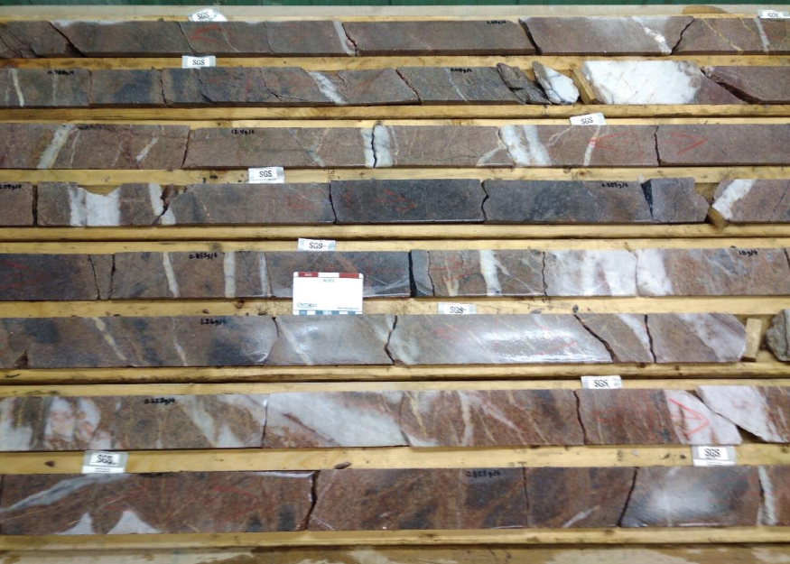
Rocks specimens:
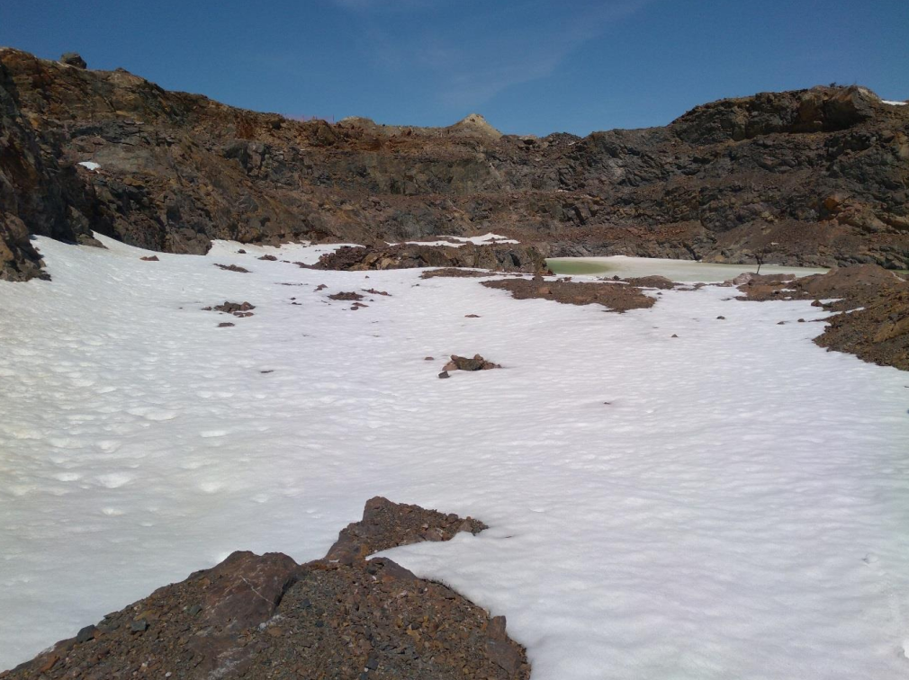
Garrcon Bulk Sample Pit Showing Strongly Altered Rock
Mineralization:
Gold occurs primarily as native gold within the stockwork veins with minor dissemination into the vein walls. Higher grade intersections (above 10 g/t) are frequently intersected in intervals where pyrite makes up much less than 1% of the total rock. The principal minerals are native gold, pyrite, magnetite, specularite and pyrrhotite with subordinate chalcopyrite, sphalerite, galena and arsenopyrite. Pervasive wall rock alteration is common adjacent to the veins, usually consisting of carbonatization (ankerite or ferroan dolomite) and minor sulphides (pyrite and pyrrhotite).
Ore specimens:
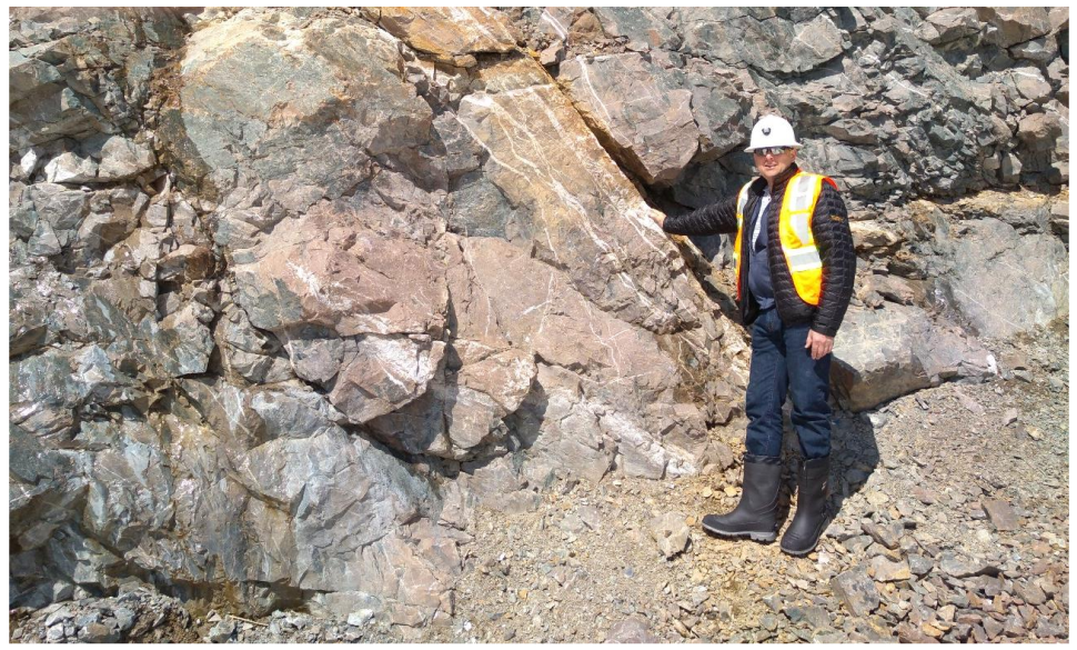
Close-up of Veining and Alteration in the Garrcon Pit
Altered and Veined Drill Core
Deposit types:
The Garrison Project Deposits are structurally-controlled orogenic gold deposits in an Archean greenstone belt. Robert (1998) has provided an updated statement of the geological characteristics of Archean gold deposits (an update of Robert 1996).
Robert has concluded that a close examination of the geological characteristics of Archean world-class gold deposits reveals a significant diversity in the nature and chemistry of the
mineralization/ore, hydrothermal alteration, and lithological or structural associations. Several geological styles of deposits can be distinguished:
- Quartz-carbonate veins in shear zones, faults and folds, and related extensional structures,
- Zones of stockwork veinlets and disseminated sulphides associated with small porphyry intrusions,
- Sulphide-rich veins and vein arrays,
- Gold-rich volcanogenic massive sulphide (VMS) lenses in felsic volcanic rocks, and
- Rare carbonate-rich veins and siliceous replacements.
Geological relationships suggest that the porphyry-style, gold-rich VMS and possibly epithermal-style deposits have formed during the stages of construction (volcanic-plutonic activity) of the greenstone belts at depths of less than 5 km, whereas orogenic deposits have formed during deformation at depths in excess of 5 km.
These different styles of gold deposits commonly occur within the same districts or along the same fault zones, indicating that gold deposits within a given district formed at different crustal levels, at different times, and by different processes, and have been juxtaposed by successive episodes of burial, uplift and deformation that have been focused in certain areas.
With specific reference to the southern Abitibi Greenstone Belt, where the Garrison Property is located, Robert notes that development begins with the accumulation of volcanic rocks in one or more cycles and the emplacement of coeval igneous intrusions. This represents the main phase of construction of volcanic-plutonic edifices, which is partly accompanied by, but mostly followed by, turbidite (greywacke, shale and siltstone) sedimentation. This main phase of construction was followed by a first episode of deformation (D1) tilting, folding and over-thrusting of supracrustal units, accompanied by diorite-tonalite intrusions. Subsequent uplift and erosion led to the deposition of alluvial-fluvial Timiskaming-type sedimentary rocks above an angular unconformity. This Timiskaming stage can be regarded as a renewed stage of volcano-plutonic construction as it was accompanied by the emplacement of high-level intrusives and volcanic rocks of alkalic composition. The Timiskaming stage was followed by the main period of deformation of the volcanic-plutonic edifices, beginning with regional D2 deformation shortening across the belt and evolving into D3 transcurrent deformation.
Quartz-carbonate vein deposits consist of networks of quartz-carbonate veins in moderately to steeply dipping brittle-ductile shear zones and related extensional veins and vein arrays and breccia veins in relatively competent lithologic units. The deposits are spatially associated with major shear zones but have a tendency to be hosted by second and third order structures and splays. In the larger deposits, the vein networks have a surface footprint exceeding 1 km of strike length and generally extend vertically to depths of 1 km or more (the McIntyre mine’s deepest levels were at approximately 2.5 km below surface - though this information is not necessarily indicative of the mineralization on the Property).
Robert further noted that there is a strong association of world-class deposits with districts that contain a large proportion of mafic and ultramafic volcanic rocks. In the Timmins gold camp, all of the above-mentioned styles of mineralization can be found, and multiple styles can be found within a single mine, for example the Dome and Hollinger- McIntyre mines.
In the Timmins gold camp, all of the above-mentioned styles of mineralization can be found, and multiple styles can be found within a single mine, for example the Dome and Hollinger- McIntyre mines.
In quartz-carbonate vein deposits gold mineralization occurs in both the veins and in adjacent altered wall rocks, with the bulk of the gold found in the veins. The mineralized veins consist of quartz and carbonate minerals, with subordinate amounts of pyrite, arsenopyrite, pyrrhotite, native gold, base metal sulphides, tourmaline, scheelite, talc, sericite and chlorite. Alteration envelopes, a few metres to tens of metres thick, surround the veins, and may consist of reduced carbon, carbonatization, potassium metasomatism, sodium metasomatism, sulphidization and silicification (Card et al, 1988).
Carbonatization is the most common and most extensive type of alteration in quartz vein deposits. This type of alteration involves the progressive replacement of Ca, Fe and Mg silicate minerals by carbonate species through the addition of carbon dioxide and is inwardly zoned from calcite to ankerite and dolomite. Potassium metasomatism is found in close proximity to the veins as sericitization of chlorite and plagioclase, the development of K-feldspar and biotite and the presence of fuchsite in ultramafic rocks. Sulphidation is restricted to the immediate wall rocks of the veins. Pyrite is the dominant sulphide with lesser amounts of pyrrhotite and arsenopyrite, but the volume of total sulphide minerals is generally less than 10%. Sodium metasomatism results in the formation of albite and paragonite. Silicification results in quartz flooding of the host rocks and an abundance of quartz veinlets and stockworks.
At the district and property scale, exploration for quartz-carbonate vein gold deposits focuses on broad transpressional shear zones located along lithologic boundaries. The gold mineralization tends to occur within structures measuring hundreds to thousands of metres long that are subsidiary to major fault zones. At a more local, scale mapping of alteration mineral assemblages can delineate favourable portions of shear zones. Even though the sulphide content of the quartz veins and the associated wall rock alteration is low, induced polarization and resistivity geophysical methods result in a recognizable chargeability response, while the increased quartz content is recognized as an increase in resistivity. Carbonatization causes destruction of magnetic minerals in mafic rocks, creating a negative magnetic feature coincident with alteration surrounding the lode deposits. In glaciated areas, geochemical surveys using heavy mineral concentrates derived from sampling till can be used to define areas of potential lode gold mineralization. In addition, Mobile Metal Ion-type soil geochemical surveys have proven to be applicable in overburden covered areas.
Note:
Notes for mineral resources for the effective date 2019-02-19:
- Ore weight and gold ounce values are rounded to the nearest thousand, which may result in visible discrepancies.
- Notes from goldmap.info: mineral resources are presented in aggregate, without differentiation by mining method. The calculation was completed by goldmap.info and includes gold resources expressed in metric tonnes and average grades. The original estimates were based on different cut-off grades: 0.4 g/t for open-pit and 3 g/t for underground.
Notes for mineral resources for the effective date 2020-11-25:
- The mineral resource for O3 Mining’s Garrison deposits has been updated since the previous estimate in 2019 due to updated geologic modelling, updated QA/QC and updated gold prices.
- The base case cut-off grade is 0.30 g/t Au based on mill recoveries of 95.5% at Garrcon. Processing + G&A costs of C$16.90/t and a US$1400/oz Au were used, with smelter terms as detailed in the notes below.
- The open pit mineral resource has been confined by a “reasonable prospects of eventual economic extraction” pit shell generated using the following assumptions: US$1,800/oz. Au at a currency exchange rate of US$0.75 per C$1.0; 99.95% payable Au; C$4.30/oz Au off-site costs (refining, transport and insurance); a 2% NSR royalty; C$14.50/t process and G&A costs; C$2.40/t mining costs and pit slopes of 25° in the overburden and 40° below the overburden. Metallurgical recovery is 95.5% at Garrcon.
- The specific gravity of the deposit has been determined by lithology as being between 2.74 and 3.32.
- Numbers may not add due to rounding.
Mineral Resources (Feb. 19, 2019)
| Class | Ore (ktonnes) | Au grade (g/t) | Au (kg) | Au (oz * 1000) |
|---|---|---|---|---|
| Measured | 13259.00 | 0.88 | 11667.92 | 377.00 |
| Indicated | 7452.00 | 1.11 | 8304.64 | 267.00 |
| Inferred | 2834.00 | 1.83 | 5194.29 | 167.00 |
Mineral Resources (Nov. 25, 2020)
| Class | Ore (ktonnes) | Au grade (g/t) | Au (kg) | Au (oz * 1000) |
|---|---|---|---|---|
| Indicated | 20923.00 | 0.82 | 17177.78 | 552.00 |
| Inferred | 7056.00 | 0.87 | 6110.50 | 197.00 |
Source:
-
N.I. 43-101 TECHNICAL REPORT & PRELIMINARY ECONOMIC ASSESSMENT OF THE GARRISON PROJECT
(27.01.2021, Toronto)
Authors: Raponi Tommaso Roberto, Elfen Scott, Weston Scott, Petrina Mike, Bird Susan -
A Mineral Resource Estimate For The Garrcon, Jonpol And 903 Zones At The Garrison Project, Garrison Township, Black River - Matheson Area, Northeastern Ontario
(04.04.2019, Toronto)
Authors: Hennessey Terrence