Jonpol
Phase: Exploration
Mine Type: Pit, Underground
Tags: albite alkaline ankerite archean argillite basalt breccia calcite carbonatization chalcopyrite chlorite conglomerate diabase dolomite dyke galena granite greenstone belt greywacke hematite komatite lamprophyre magnetite mariposite monzonite pyrrhotite sandstone schist sericite silicification siltstone specularite sphalerite stock stockwork syenite talc
Canada, Ontario.
The Jonpol deposit is part of the so-called Garrison property, which also includes Garricon and Zone 903.
History:
The exploration and development history from 1935 to 1989 has been extracted from Bath (1990) with metric equivalents inserted by Howe:
Pre-1946: The claim group was staked by G. Adams and was later optioned to Wright-Hargreaves Mines Ltd. Wright-Hargreaves Mines diamond drilled 4 holes totaling 2,742 feet (Satterly 1949).
1946-1947: Dome Exploration (Canada) Ltd. acquired the property and formed Newfield Mines Ltd. to explore it. Newfield Mines diamond drilled 20 holes totaling 16,164 feet (Satterly 1949), most of which were drilled in the south part of the property in an attempt to locate an eastern extension of an auriferous zone which had been intersected via diamond drilling by Wright-Hargreaves Mines on patented claim no. 43903. Results of the Newfield Mines drilling included auriferous intersections of 0.22, 0.17, 0.27, and 0.45 oz/ton Au across core lengths of 1.4, 4.8, 2.8, and 2.0 m, respectively, and additional "commercial" values in pyritic syenitic or feldspar porphyry.
1987: T & H Resources Ltd. (a member of the Jonpol group of companies) optioned the northernmost block of 9 claims (nos. 26435-37, 39428-29, 43702-03, and 44331-32) from Newfield Mines (The Northern Miner, July 6, 1987). Newfield Mines retained a 30% net profit interest. Jonpol Explorations Ltd. (a member of the Jonpol group) later earned a 50% interest in the T & H Resources property interest. T & H Resources and Jonpol Explorations completed magnetic and VLF electromagnetic surveys (T & H Resources Ltd. 1987 Annual Report) and diamond drilled 38 holes totaling 29,289 feet.
1988: Findore Resources Inc. optioned from Newfield Mines the southernmost block of 5 patented claims. Coastoro Resources Ltd. (a member of the Jonpol group) acquired a 20% interest of the T & H Resources X Jonpol Explorations interest in the northern 9 claims, and the Jonpol group raised $3 million to be spent in the area during 1988 (The Northern Miner, January 18, 1988). In February, Findore Resources optioned its Newfield Mines claims to Morgain Minerals Inc. and Orcana Resources Inc. (The Northern Miner, February 15, 1988). By March, gold mineralization on the Jonpol group controlled ground was reported (T & H Resources 1987 Annual Report) to consist of 3 mineralized Zones (the JP, the RP, and the JD) extending with breaks along about 2,200 feet of strike. By May, T & H Resources agreed to "... arrange a pooled interest merger with Coastoro..." (The Northern Miner, May 9, 1988). By June, drill defined reserves of 914,500 tons of material averaging 0.235 oz/ton Au in the JP Zone and 83,000 tons of material averaging 0.234 oz/ton Au in the RP Zone had been delineated (The Northern Miner, June 13, 1988). By June 30, aggregate drilling on the property totaled about 105,000 feet in 103 holes (A. D. Drummond, project engineer, Jonpol group of companies, pers. comm., July 15, 1988). In July, Lac Minerals Ltd. obtained a right to acquire a 50% interest in the Jonpol group controlled part of the property (The Kirkland Lake Northern Daily News, July 7, 1988; The Northern Miner July 11, 1988). As of August 25, 1988, aggregate drilling by the Jonpol group totaled 132,697 feet in 136 holes (A. D. Drummond, pers. comm. August 1988). Drill defined reserves were revised to 1. 3 million tons of material averaging 0.231 oz/ton Au (The Northern Miner, September 5, 1988). The Garrison Township assets of T & H Resources and Coastoro Resources were consolidated under the name T & H Resources (The Northern Miner, October 10, 1988). Lac Minerals optioned the property in November (The Northern Miner, November 21, 1988).
1989: T & H Resources and Jonpol Explorations began underground exploration, including the sinking of a 500 foot deep 3 compartment vertical exploration shaft (Jonpol Explorations Ltd. 1989 Annual Report; The Northern Miner, June 19, 1989). By September, the shaft had reached the 485 foot level and stations had been established on the 250 and 475 foot levels (Jonpol Explorations Ltd. / T & H Resources Ltd. Interim Report dated September 30, 1989).
1990: T & H Resources and Jonpol Explorations underground program was completed in March, 1990. Work included:
- 184 m (605 ft) vertical 6.7 x 2.7 m 3-compartment shaft.
- 185 m of 1.5 x 2.1 m cross cut and drill stations.
4,747.2 m (15,575 feet) of AXT drilling in 42 holes. - 182.2 m of Bazooka (AXT) drilling in 22 holes into walls of the 476 ft (150 m) level drift.
- 147.8 m of drifting in the JP Main Zone on the 476 ft (150 m) below surface level.
- bulk sampling, 79 rounds.
Metallurgical testing at Lakefield Research in November, 1990 indicated that the material from the JP Main Zone in the Munro Fault Zone gives 50% recovery with direct cyanidation. Flotation concentrates contained 95% of the gold in the rougher concentrate which, when cleaned, could produce cleaner concentrates in the 4 to 8 oz/ton Au range. Pressure oxidation cyanide leach tests of the concentrate recovered 99% of the contained gold suggesting a potential gold recovery of 95% using that system. The underground bulk sample rounds contained 0.3 to 1.4% As (Squair, 2000).
1990: Jonpol and T & H Resources Limited concluded an option agreement with Lac Minerals Ltd. which expanded the existing property and allowed Jonpol and T & H the opportunity to conduct underground exploration on the JP Zone, investigate the westward extension of the JD Zone onto the Hastings ground (specifically claims L39876 and 43863) (Squair, 2000).
1991: The Lac Minerals agreement was terminated and the Hastings and Wright-Hargreaves properties along with five peripheral claims south of the Garrcon were returned to Lac (Squair, 2000).
1992: Jonpol completed seven drill holes totalling 796 m.
1994: Jonpol drilled three diamond drill holes (N-94-1, 2 and 3), with a northwest azimuth, on claims P-26435 and P-26434 to test for the western down-plunge extension of the JP Zone (Squair, 2000). Total footage drilled was 5,128 ft between September 24 and October 22, 1994. A four-line (3800W to 4400W) Mise-a-la-Masse geophysical survey was then completed to determine the near surface conductivity of the auriferous sulphide in drill hole N-94-1.
1995: Jonpol completed a follow-up diamond drilling program (Phase 2) to test strata and shear zones down dip and on strike from drill hole N-94-1 on claims 43703, 26433, 26434 and 26435. During the period from January 26 to February 16, 1995, six BQ-sized diamond drill holes totalling 3,550 ft were completed (N-95-1 to N-95-6). A four-hole, 9,200-ft, Phase 3 drill program was then planned to test the potential for possible gold concentrations at the basal basalt/ultramafic contact and within felsic volcanic and intrusive rocks above the upper thrust of the Munro Fault to the east of the JP Deposit and down plunge from the Garrcon West (now Jonpol East) Zone. Two drill holes of the four-hole program, N-95-7 and N-95-8, were laid out on claims 38950 and 39429. Drill hole N-95-7 was completed September 16, 1995. Hole N-95-8 was lost at 1,270 ft in sheared ultramafic near the top of the Munro Fault. Repeated efforts to cement and drill through the zone were unsuccessful, and the hole plus the remainder of the program was abandoned on October 22, 1995. The two holes totaled 3,767 ft. Gold and silver assays for 269 samples from 30 sulphide intersections within the two holes were of geochemical interest only, but the program demonstrated that anomalous gold values occur within non-refractory sulphides (pyrite) south of the Munro Fault. A six-line Mise-a-la-Masse survey was conducted to determine near surface conductivity around hole N-95-7.
1996 to 1997: On May 29, 1995, Jonpol Explorations Ltd. and T & H Resources Ltd. signed a letter of intent with Hillsborough Resources Limited (Hillsborough) to complete a Joint Venture agreement whereby Hillsborough would be granted an option to carry out an advanced exploration program at the JP Zone. Under the agreement Hillsborough would undertake to develop and mine the known gold-bearing albite-sericite-pyrite zones and ship ore to a custom mill and smelter at Noranda, Quebec. After recovery of Hillsborough’s initial costs, the parties would share net smelter proceeds, if any, from the advanced mine program. The Hillsborough option encompassed all known gold-bearing zones on the Newfield and Garrcon Group of claims, to a vertical depth of 305 m (1,000 ft) from the shaft collar on patented claim 43703. Work was carried out on claims 43702 and 43703. Canadian Mine Development, a wholly owned subsidiary of Hillsborough Resources conducted the permitting and development work. Permitting for the advanced exploration program began June 12, 1995. The mine closure plan was accepted by the Ontario Ministry of Natural Resources (MNR) on August 24, 1995, and site operations began in mid-October, 1995, with the excavation of the decline portal and the establishment of ore and waste pads. At the beginning of the test program, Hillsborough established an on-site fire assay laboratory to ensure that sample and assay results kept pace with mine development. The mineralized zone was developed from a 12 ft x 14 ft (3.7 metre by 4.3 metre), 18°-20° decline excavated to the 476 Level. A ventilation raise connected the 350 Level to surface. Mineralized material was removed by drifting and benching on 6 levels between 80 and 150 m below surface. The first gold-albite-sericite-pyrite-arsenopyrite test samples were shipped to the Noranda custom mill and smelter complex in September, 1996. Between September, 1996 and April, 1997, 55,751 short wet tons or 54,109 short dry tons of mineralized rock were shipped to the Noranda custom mill and smelter complex. Choi (1997) reports that the total recovered gold was 9,476 ounces and total gold lost to tailings was 1,100 ounces for total available gold of 10,576 ounces, a recovery of 89.60% and a calculated feed grade of 0.1955 oz/ton Au. The calculated feed grade of 6.70 g/t (0.1955 oz/ton) Au was much lower than the estimated grade of 8.33 g/t (0.243 oz/ton) Au (Squair,2000). The advanced underground exploration program was terminated on March 29, 1997. Mine closure and environmental clean-up procedures were completed and the Hillsborough option was terminated in 1997. A minimum of 458,000 tons at 0.28 oz/ton Au were reported to remain in place at the JP Zone (Squair, 2000).
2005 to 2008: ValGold completed 63 NQ-sized diamond drill holes on the Jonpol Deposit totalling 26,646.3 m.
2009 to 2015: Northern Gold completed three years of drilling: 2011, 2012 and 2013. In the Jonpol Deposit, diamond drill programs focused on infill drilling and expanding the mineral
resource. A total of 20,827.4 m were drilled in 75 drill holes. Northern Gold also completed re-logging of approximately 44,000 m of historic core with some sampling of previously un-assayed portions. In 2013, Northern Gold announced preliminary metallurgical test work results on samples taken from the Jonpol Deposit. Three composite drill core samples were selected by Northern Gold from the Company’s drilling on the JD, RP and East Zones of the Jonpol Deposit. The 2011 IP geophysical survey also covered the Jonpol area, as did the 2010 and 2013 magnetic and VLF/EM survey.
In 2010 to 2013, Northern Gold’s diamond drill program focused on infill and step-out drilling on the Jonpol Deposit. In 2011, six Garrcon drill holes were extended into the Jonpol Deposit area totalling 2,262 m. In 2012, (March to May and September to December), 39 drill holes were drilled in the Jonpol Deposit area, totalling 8,765.1 m. Of these 39 2012 drill holes, six holes were geotechnical holes totalling 1,042.5 m. Three drill hole extensions were also completed in 2012, totalling 1,064 m. An additional 26 holes were completed in 2013 (January to May), totalling 7,982.3 m. One drill hole wedge (JP13-16A) totalling 771 m was also completed in 2013. Two 2012 holes required restarts.
Regional geology: Abitibi greenstone belt
Abitibi greenstone belt of the Superior province of the Canadian Shield. The area consists mostly of felsic to mafic volcanic rocks of Archean age together with related dioritic sills which are concordant to the regional rock formations. These volcanic and intrusive rocks have generally been metamorphosed to the greenschist facies.
The Superior Province is the largest exposed Archean craton in the world and hosts several world class gold deposits. It has yielded nearly 300 million ounces of gold from hundreds of deposits since the beginning of the twentieth century. One prominent characteristic of all significant gold deposits in the Superior Province is their occurrence within or immediately adjacent to greenstone belts. Another characteristic is their occurrence within major tectonic zones which comprise a series of shear zones (Colvine et al., 1988). The Superior Province is divided into four major subprovince types (Card and Ciesielski, 1986): volcano-plutonic, plutonic, metasedimentary, and high metamorphic grade gneiss. The boundaries of these subprovinces are either major dextral, transcurrent, east-striking faults, or zones of structural and metamorphic transition.
The greenstone belts which host the gold deposits occur as east-north-easterly trending ribbon domains in the volcano-plutonic terrains. They typically consist of mafic to ultramafic and felsic metavolcanic …
Local geology:
Description of local geology in the section deposit Garrcon.
Deposit geology:
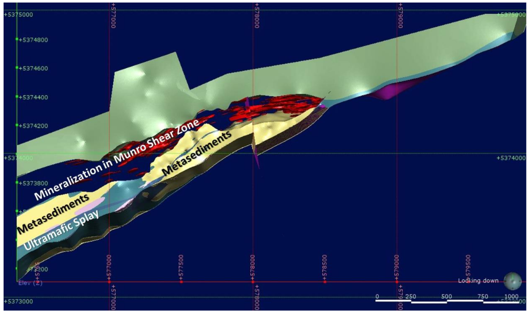
The Jonpol Deposit is a zone of gold mineralization hosted in structurally controlled alteration zones within mafic to ultramafic (tholeiitic to komatiitic) rocks along the north contact of the Munro Fault, which crosses the north-central part of the property. Jonpol gold mineralization is generally associated with pervasive carbonate alteration with late stage silicification, sulphidization (pyrite and arsenopyrite) and sericitization, giving the altered rock a pale beige to pale purple-grey hue.
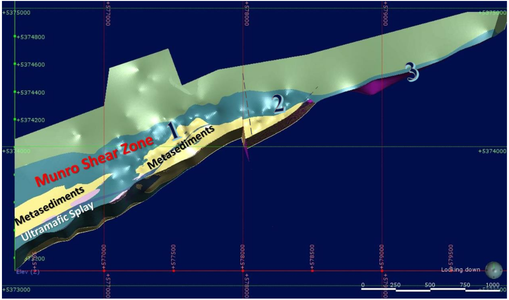
Previously, the Jonpol Zone was modelled as four contiguous mineralized zones (JD, JP, RP and East Zone), along the Munro Fault, which is a splay from the regional Porcupine-Destor Fault. RockRidge consolidated the Jonpol Zone into three contiguous structurally bounded zones: west of the Garrison Fault, immediately east of the Garrison, and Far East (Zones 1, 2 and 3). The mineralized structures strike approximately 070° (true north) and dip steeply to the south. The Jonpol Zone has a combined strike length of 2,000 m. The mineralized structures have been intersected from surface to a maximum vertical depth of approximately 750 m below surface. True widths of mineralized structures vary from 1.5 m
to greater than 10 m.
Deposit types:
See the information in the Garrcon deposit section.
Note:
Notes for mineral resources for the effective date 2019-02-19:
- Ore weight and gold ounce values are rounded to the nearest thousand, which may result in visible discrepancies.
- Notes from goldmap.info: mineral resources are presented in aggregate, without differentiation by mining method. The calculation was completed by goldmap.info and includes gold resources expressed in metric tonnes and average grades. The original estimates were based on different cut-off grades: 0.4 g/t for open-pit and 3 g/t for underground.
Notes for mineral resources for the effective date 2020-11-25:
- The mineral resource for O3 Mining’s Garrison deposits has been updated since the previous estimate in 2019 due to updated geologic modelling, updated QA/QC and updated gold prices.
- The base case cut-off grade is 0.30 g/t Au based on mill recoveries of 92.45% at Jonpol for non-refractory material and 56.2% for refractory material. Processing + G&A costs of C$16.90/t and a US$1400/oz Au were used, with smelter terms as detailed in the notes below.
- The open pit mineral resource has been confined by a “reasonable prospects of eventual economic extraction” pit shell generated using the following assumptions: US$1,800/oz. Au at a currency exchange rate of US$0.75 per C$1.0; 99.95% payable Au; C$4.30/oz Au off-site costs (refining, transport and insurance); a 2% NSR royalty; C$14.50/t process and G&A costs; C$2.40/t mining costs and pit slopes of 25° in the overburden and 40° below the overburden. Metallurgical recovery is 92.45% at Jonpol for non-refractory material and 56.2% for refractory material.
- The specific gravity of the deposit has been determined by lithology as being between 2.74 and 3.32.
- Numbers may not add due to rounding.
Mineral Resources (Feb. 19, 2019)
| Class | Ore (ktonnes) | Au grade (g/t) | Au (kg) | Au (oz * 1000) |
|---|---|---|---|---|
| Measured | 4085.00 | 1.70 | 6947.23 | 223.00 |
| Indicated | 3080.00 | 1.55 | 4770.48 | 153.00 |
| Inferred | 471.00 | 1.86 | 875.65 | 29.00 |
Mineral Resources (Nov. 25, 2020)
| Class | Ore (ktonnes) | Au grade (g/t) | Au (kg) | Au (oz * 1000) |
|---|---|---|---|---|
| Indicated | 17786.00 | 0.91 | 16185.26 | 523.00 |
| Inferred | 7521.00 | 0.76 | 5685.88 | 183.00 |
Source:
-
N.I. 43-101 TECHNICAL REPORT & PRELIMINARY ECONOMIC ASSESSMENT OF THE GARRISON PROJECT
(27.01.2021, Toronto)
Authors: Raponi Tommaso Roberto, Elfen Scott, Weston Scott, Petrina Mike, Bird Susan -
A Mineral Resource Estimate For The Garrcon, Jonpol And 903 Zones At The Garrison Project, Garrison Township, Black River - Matheson Area, Northeastern Ontario
(04.04.2019, Toronto)
Authors: Hennessey Terrence