The Livengood property is located approximately 70 mi (113 km) by road (47 mi (75 km) by air) northwest of Fairbanks, Alaska in the Tolovana Mining District within the Tintina Gold Belt. The deposit area is centered near Money Knob, a local topographic high point. This feature and the adjoining ridge lines are the probable lode gold source for the Livengood placer deposits that lie in the adjacent valleys. These placer deposits have been actively mined since 1914 and have produced more than 500,000 oz of gold.
History
Gold was first discovered in the gravels of Livengood Creek in 1914 (Brooks, 1916) and led to the founding of the Town of Livengood. Subsequently, more than 500,000 oz of placer gold has been produced. From 1914 through the 1970s, the primary focus of prospecting activity was placer deposits. Historically, prospectors considered Money Knob and the associated ridgeline the source of the placer gold. Prospecting, primarily in the 1950s and in the form of dozer trenches, was carried out for lode type mineralization in the vicinity of Money Knob. However, no significant lode production has occurred to date.
Since the 1970s, the property has been prospected and explored by several companies; Geochemical surveys by Cambior Inc. in 2000 and AngloGold Ashanti (U.S.A.) Exploration Inc. (AGA) in 2003 and 2004, outlined a 1.0 × 0.5 mi (1.6 × 0.8 km) square area with anomalous gold in soil. Scattered anomalous samples continue along strike for an additional 1.2 mi (2 km) to the northeast and 1 mi (1.6 km) to the southwest. Eight reverse circulation (RC) holes were drilled by AGA in 2003 and a further four diamond core holes were drilled in 2004 to evaluate this anomaly. Favorable results from these holes revealed wide intervals of gold mineralization (BAF-7: 455 ft (138.7 m) @ 1.07 g/mt Au; MK-04-03: 181.4 ft (55.3 m) @ 0.51 g/mt Au) along with lesser intervals over a broad area. In 2006, AGA sold the Livengood Gold Project to ITH. In the same year, THM drilled a 4,026 ft (1,227 m), seven-hole core program. The success of that program led to the drilling of an additional 14,432 ft (4,400 m) in fifteen diamond core holes in 2007 to test surface anomalies, expand the area of previously intersected mineralization, and advance geologic and structural understanding of the deposit. Subsequent programs have continued to expand the resource, leading to consideration of development of the deposit. Concomitant programs have included geotechnical, engineering, and metallurgical work, along with the collection of environmental baseline data. As of the end of 2014, completed exploration and delineation drilling totals 574,599 ft (175,138 m) in 621 RC holes, and 140,854 ft (42,932 m) in 151 core drillholes.
From 2013 through 2016, additional metallurgical testwork was performed, along with various techno-economic trade-off studies, to form the basis for the optimized project configuration.
Regional Geology
The Livengood deposit is hosted by rocks of the Livengood Terrane, an east–west belt, approximately 150 mi (240 km) long, consisting of tectonically interleaved assemblages, which include:
i) the Amy Creek assemblage, a sequence of latest Proterozoic and/or early Paleozoic basalt, mudstone, chert, dolomite, and limestone;
ii) a Cambrian ophiolite sequence of mafic and ultramafic sea floor rocks thrust over the Amy Creek Assemblage, in turn overthrust by;
iii) a sequence of Devonian clastic sedimentary, volcanic, and volcaniclastic rocks (Athey, et al., 2004).
The Devonian rocks are the dominant host to the mineralization at Livengood and have been informally subdivided into “Upper Sediments” and “Lower Sediments” stratigraphic units, separated by volcanic rocks (“Volcanics” or “Main Volcanics”). The Devonian assemblage was overthrust by a second klippe of Cambrian ophiolite and structurally intercalated cherty sedimentary rocks (“Money Knob”). All of these rocks are intruded by post-thrusting, Cretaceous (91.7 – 93.2 My; Athey, Layer, and Drake, 2004) multiphase monzonitic and syenitic dikes; gold mineralization is spatially and temporally associated with these intrusive rocks.
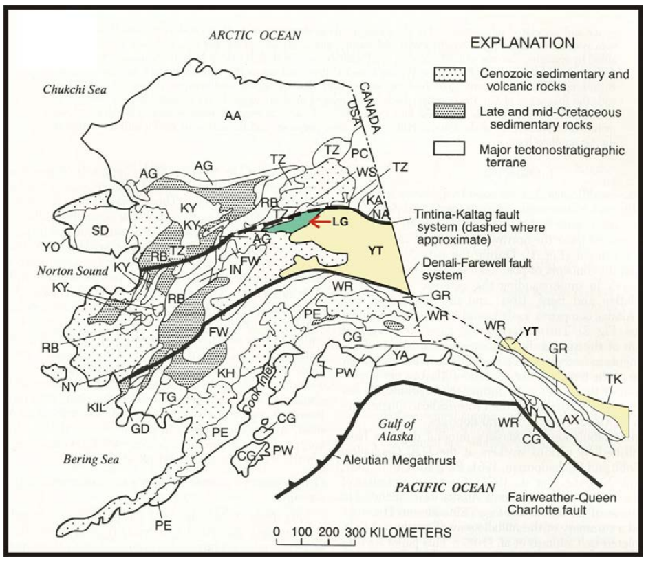
Terrane map of Alaska showing Livengood Terrane (LG: red arrow) The heavy black line north of the Livengood Terrane is the Tintina Fault. The heavy black line to the south of the Livengood and Yukon-Tanana Terrane (YT) is the Denali Fault. The Tintina Gold Belt lies between these two faults (after Goldfarb, 1997)
Deposit Geology and Mineralization
Gold mineralization is associated with disseminated arsenopyrite and pyrite in volcanic, sedimentary and intrusive rocks, and in quartz veins cutting the more competent lithologies, primarily volcanic rocks, sandstones, and to a lesser degree, ultramafic rocks. Mineralization appears to be contiguous over a map area approximately 2.5 km2; a 0.1 g/mt grade shell averages 920 ft (280 m) thick and drilling has not closed off the deposit at depth. The stronger zones of mineralization are associated with areas of more abundant dikes. South of the Lillian Fault individual mineralized envelopes are tabular and follow stratigraphic units, particularly the Devonian volcanics, or lie in envelopes that dip up to 45° to the south, mimicking the structural architecture and attitude of the diking. On the north side of the Lillian fault, mineralization is similar in style and orientation and hosted primarily in steeply dipping Upper Sediments. Three principal stages of alteration are currently recognized; in order from oldest to youngest, these are characterized by biotite, albite, and sericite. Arsenopyrite and pyrite were introduced primarily during the albite and sericite stages. Gold correlates strongly with arsenic and occurs primarily within and on the margins of arsenopyrite and pyrite grains. Carbonate was introduced with and subsequent to these stages. Dating of the sericite alteration (Athey, Layer, and Drake, 2004) indicates that mineralization and alteration were contemporaneous with the emplacement of the dikes.
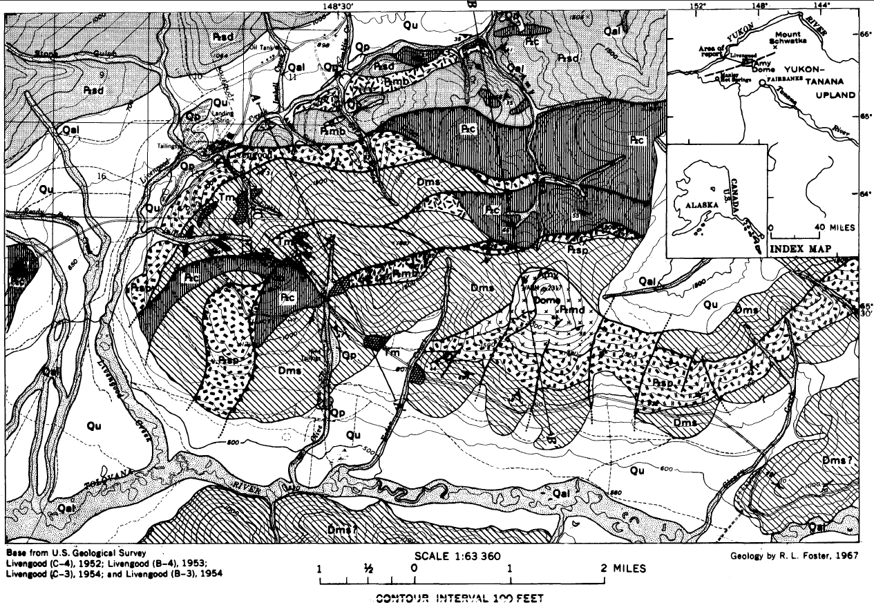
Geologic map of the Livengood district.
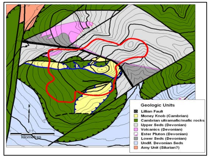
Generalized geologic map of the Money Knob area based on geologic work by THM (Red outline is the surface projection of the gold deposit)
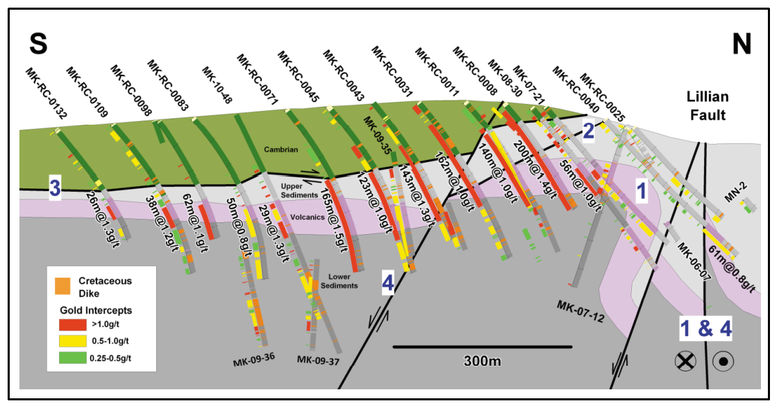
Cross section through the deposit (Blue numbers indicate possible sequence of structural events: 1) Fold thrust development in the Permian (?); 2) NE-trending cross faults; 3) Thrust emplacement of Cambrian sheet; 4) Extensional collapse, all of which pre-date dike emplacement and coeval mineralization.)
Deposit types
Among gold deposits of the Tintina Gold Belt, Livengood mineralization is most similar to the dike and sill-hosted mineralization at the Donlin Creek deposit, where gold occurs in narrow quartz veins associated with dikes of similar composition (Ebert, et al., 2000). The age of the intrusions and the coincidence of mineralization and intrusive rocks are typical of those of other nearby gold deposits of the Tintina Gold Belt, which have been characterized as intrusion-related gold systems (Newberry and others, 1995; McCoy and others, 1997). For these reasons Livengood is best classified with these deposits.
Mineral Resource & Reserve Estimate
Mineral Reserve estimate for the Project (effective as of October 22, 2021). These Proven and Probable Mineral Reserves formed the basis of the economic evaluation of the Project and are based on a gold price of US$1,680 per ounce. The economic assumptions and parameters used for the calculation of reserves are the same as those used for the PFS financial model. Note that tonnages presented are in the metric system.
- Mineral Reserves are reported using the 2014 CIM Definition Standards and are estimated in accordance with 2019 CIM Best Practices Guidelines.
- Mineral Reserves are estimated using a gold price of US$1,680 per ounce, and consider a 3% royalty, 1.80/oz for smelting, refining, and transportation costs, and a gold payable of 99.9%
- Metallurgical recovery curves were developed for each rock type, with the Mineral Reserves having the following tonnage weighted averages; 83.3%, for Rocktype 4, 79.8% for Rocktype 5, 73.5% for Rocktype 6, 66.4% for Rocktype 7, 58.7% for Rocktype 8 and 57.1% for Rocktype 9, including 22% for massive stibnite mineralization.
- As a result of the complex metallurgical recovery equations, it is difficult to determine specific cut-off grades. The following presents the lowest gold grades for each rocktype that are processed in the life of mine plan; 0.26 g/t for Rocktype 4, 0.28 g/t for Rocktype 5, 0.31 g/t for Rocktype 6, 0.31 g/t for Rocktype 7 and 0.42 g/t for Rocktype 8 and 0.42 g/t for Rocktype 9.
- The strip ratio for the open pit is 1.2 to 1.
- The Mineral Reserves are inclusive of mining dilution and ore loss.
- The reference point for the Mineral Reserves is the primary crusher.
- Totals may not add due to rounding.
- The foregoing mineral reserves are based upon and are included within the current mineral resource estimate for the Project.
The mineral resource estimates set forth in the PFS (“2021 MRE”) have been prepared by Resource Development Associates Inc. (“RDA”). Compared to the mineral resource estimates in the 2017 Report, the 2021 MRE included spatial modelling of the occurrence of antimony throughout the deposit as well as modelling of the locations of massive stibnite veins within the deposit. These details add valuable contributions to the reasonable prospects of eventual economic extraction of gold for the Project.
Mineral Resources & Reserve Summary Table
Source: NI 43-101 Technical Report @Pre-feasibility study of the Livengood gold project; Effective Date: March 8, 2017; BBA Inc;
Colin A. Hardie, P. Eng. ............... BBA Inc.
Ryan T. Baker, P.E. ...................... NewFields Mining Design & Technical Services, LLC
Michael E. Levy, P.E. ................... SRK Consulting (U.S.) Inc.
Timothy J. Carew, P. Geo. .......... .SRK Consulting (Canada) Inc.
Scott E. Wilson, CPG. ................. Metal Mining Consultants Inc.
Timothy J. George, P.E. .............. Wildcat and Badger, LLC


