Pump
Mine Type: Pit, Underground
Tags: ankerite arsenopyrite basalt bif biotite calcite chert chlorite dyke gabbro greenstone belt pyrrhotite
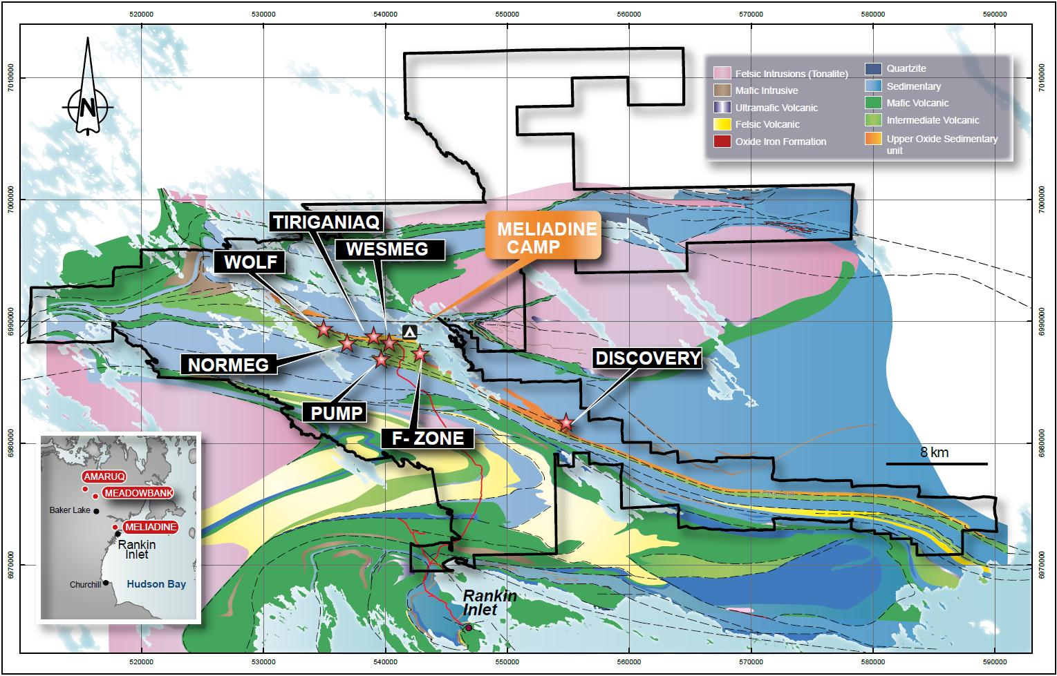
The Meliadine gold project (including the Wesmeq deposit) is located in the Kivalliq District of Nunavut in northern Canada, approximately 25 km northwest of Rankin Inlet on the west coast of Hudson Bay. A private all-weather access road constructed by Agnico Eagle connects Rankin Inlet to the Meliadine project. The current Meliadine exploration camp is located on the shore of Meliadine Lake, approximately 2.3 km east of the Tiriganiaq deposit.
Regional geology: Rankin Inlet Greenstone Belt
Located in the Northwest Hearne Sub-domain of the Churchill Structural Province that forms part of the northern Canadian Shield. Supracrustal rocks of this belt consist of mafic volcanic rocks, felsic pyroclastic rocks, sedimentary rocks and gabbro sills of about 2.7 billion years old that have been polydeformed and metamorphosed (Bannatyne, 1958; Laporte, 1983; Tella et al., 1986; Tella, 1994).These rocks were deformed in both the Archean and Proterozoic eras.
Meliadine area regional geology:
Deposit geology:
The stratigraphic sequence in the Pump deposit area strikes northwest-southeast and dips 50º to the north.
As at F zone, the host rocks for the Pump deposit are chlorite-rich massive to pillowed basalts of the Wesmeg Formation, which are cut by rare gabbro dykes and interflow sediments. At Pump, there are three types of chert-rich iron formations in the Lower Lean Iron Formation: chert-magnetite-chlorite iron formation, grunerite-cummingtonite-rich iron formation, and sulphide-rich beds in chert-dominated iron formation. Occasional metre-scale ultramafic units are noted in the sequence. The main structural feature is a kilometre-long Z-shaped fold formed by the intersection of east-west-oriented shear structures and the Lower Lean Iron Formation.
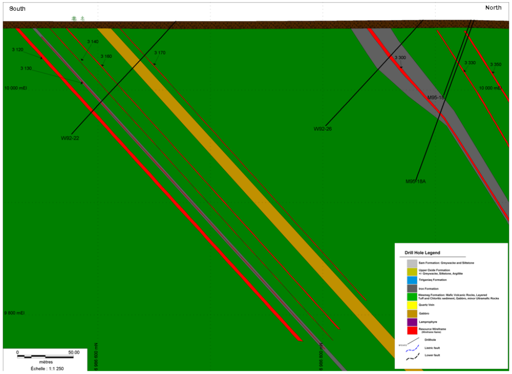
Pump vertical cross section at 15,140 E (local grid) showing geology and lode wireframes:
Mineralization:
Mineralization in the Pump gold deposit is also strongly associated with shearing and quartz veining within the Lower Lean Iron Formation, with thicker, higher-gold-grade sections
associated with east-west shearing. As at the F zone, the plunges of this thickening vary from steeply northeast to steeply northwest depending on local changes in strike.
Free gold occurs as discrete blebs in pyrrhotite and quartz shears and to a lesser extent along fractures and grain boundaries in large recrystallized arsenopyrite.
Alteration envelopes occur adjacent to quartz-calcite veining and are characterized by ankerite-, silica-, chlorite- and biotite-bearing assemblages that overprint the pre-existing regional greenschist metamorphic facies.
For the purposes of the current resource estimate, twenty domains were developed and are referred to as lodes 3100, 3110, 3120, 3130, 3140, 3150, 3160, 3170, 3200, 3210, 3220, 3230,
3300, 3310, 3320, 3330, 3340, 3350, 3360 and 3370. They were defined by tracing areas of mineralization along the Lower Lean Iron Formation from section to section.
Note:
History, local geology, deposit geology, and deposit type are described under the Tiriganiaq deposit.
For mineral resources and reserves (as at December 31, 2010):
- Inferred resources cut-off grades: surfase to 9,980 m elevation - 2.5 g/t; below 9,980 m elevation - 5.5 g/t. The table presents combined resources. Contained gold (metric tonnes) was calculated by goldmap.info.
For mineral resources and reserves (as at December 31, 2014):
- The mineral reserves are inclusive of the mineral resources
- The table presents combined open-pit and underground resources (calculated by goldmap.info)
- The gold cut-off grade for open pit mining is 2.7 g/t
- The gold cut-off for underground reserves is 4.23 g/t
- Contained gold (metric tonnes) was calculated by goldmap.info.
Mineral Resources (Dec. 31, 2010)
| Class | Ore (ktonnes) | Au grade (g/t) | Au (kg) | Au (oz * 1000) |
|---|---|---|---|---|
| Inferred | 494.00 | 6.29 | 3106.78 | 100.00 |
Mineral Resources (Dec. 31, 2014)
| Class | Ore (ktonnes) | Au grade (g/t) | Au (kg) | Au (oz * 1000) |
|---|---|---|---|---|
| Indicated | 1378.00 | 4.92 | 6779.50 | 218.00 |
| Inferred | 2326.00 | 7.62 | 17731.62 | 570.00 |
Source:
-
Updated Technical Report on the Meliadine Gold Project, Nunavut, Canada
(12.03.2015, Toronto)
Authors: Connell Larry, Petrucci François, Larouche Julie, Caron Denis, Laflamme Dany, Robichaud François, Proulx Alexandre -
Technical Report on the December 31, 2010, Mineral Resource and Mineral Reserve Estimate,
Meliadine Gold Project
(16.02.2011, Nunavut)
Authors: Duquette Dyane, Matte Pierre, Caron Bertho, Connell Larry, Fournier Julie, Petrucci François