Rankin Inlet Greenstone Belt
Tags: archean gabbro proterozoic shield sill
Description:
Located in the Northwest Hearne Sub-domain of the Churchill Structural Province that forms part of the northern Canadian Shield. Supracrustal rocks of this belt consist of mafic volcanic rocks, felsic pyroclastic rocks, sedimentary rocks and gabbro sills of about 2.7 billion years old that have been polydeformed and metamorphosed (Bannatyne, 1958; Laporte, 1983; Tella et al., 1986; Tella, 1994).These rocks were deformed in both the Archean and Proterozoic eras.
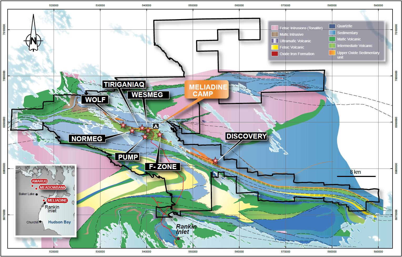
Meliadine area regional geology:
Deposits
-
Name: Tiriganiaq
Phase: Operation
Mine Type: Pit, Underground
Intro:
The Meliadine gold project (including the Wolf, Normeg, Wesmeg, Pump, West F-zone, F-zone and Discovery deposit) is located in the Kivalliq District of Nunavut in northern Canada, approximately 25 km northwest of Rankin Inlet on the west coast of Hudson Bay. A private all-weather access road constructed by Agnico Eagle connects Rankin Inlet to the Meliadine project. The current Meliadine exploration camp is located on the shore of Meliadine Lake, approximately 2.3 km east of the Tiriganiaq deposit.
The physical features of the Meliadine region have largely been determined by glaciation. The terrain consists predominantly of broadly rolling uplands and lowlands with little topographical relief (very few hills). Rankin Inlet is located on the shore of Hudson Bay with a mean elevation of 28 m above sea level. Strung out across the landscape are long, sinuous eskers. This undulating landscape is studded with innumerable lakes, ponds, and wetlands. Cryosols are the dominant soils, and are underlain by continuous permafrost with active layers that are usually moist or wet throughout the summer.
-
Name: Wolf
Phase: None
Mine Type: Pit, Underground
Intro:
The Meliadine gold project (including the Wolf, Normeg, Wesmeg, Pump, West F-zone, F-zone and Discovery deposit) is located in the Kivalliq District of Nunavut in northern Canada, approximately 25 km northwest of Rankin Inlet on the west coast of Hudson Bay. A private all-weather access road constructed by Agnico Eagle connects Rankin Inlet to the Meliadine project. The current Meliadine exploration camp is located on the shore of Meliadine Lake, approximately 2.3 km east of the Tiriganiaq deposit.
The physical features of the Meliadine region have largely been determined by glaciation. The terrain consists predominantly of broadly rolling uplands and lowlands with little topographical relief (very few hills). Rankin Inlet is located on the shore of Hudson Bay with a mean elevation of 28 m above sea level. Strung out across the landscape are long, sinuous eskers. This undulating landscape is studded with innumerable lakes, ponds, and wetlands. Cryosols are the dominant soils, and are underlain by continuous permafrost with active layers that are usually moist or wet throughout the summer.
-
Name: Normeg
Phase: None
Mine Type: Pit, Underground
Intro:
The Meliadine gold project (including the Wolf, Normeg, Wesmeg, Pump, West F-zone, F-zone and Discovery deposit) is located in the Kivalliq District of Nunavut in northern Canada, approximately 25 km northwest of Rankin Inlet on the west coast of Hudson Bay. A private all-weather access road constructed by Agnico Eagle connects Rankin Inlet to the Meliadine project. The current Meliadine exploration camp is located on the shore of Meliadine Lake, approximately 2.3 km east of the Tiriganiaq deposit.
Mineralizations
No mineralizations available.
Placers
No placers available.