Tiriganiaq
Phase: Operation
Mine Type: Pit, Underground
Tags: ankerite archean argillite arsenopyrite basalt calcite chalcopyrite chert chlorite dyke gabbro greenstone belt greywacke magnetite mudstone proterozoic pyrrhotite quartzite sericite shield sill siltstone sphalerite stockwork tonalite visible gold
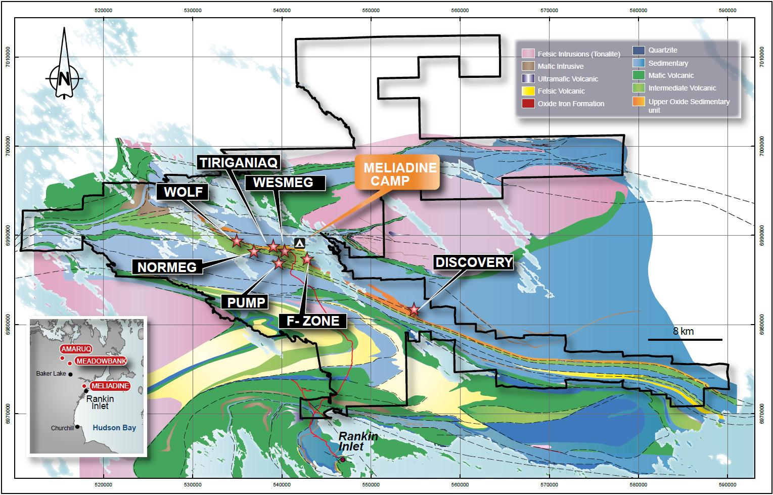
The Meliadine gold project (including the Wolf, Normeg, Wesmeg, Pump, West F-zone, F-zone and Discovery deposit) is located in the Kivalliq District of Nunavut in northern Canada, approximately 25 km northwest of Rankin Inlet on the west coast of Hudson Bay. A private all-weather access road constructed by Agnico Eagle connects Rankin Inlet to the Meliadine project. The current Meliadine exploration camp is located on the shore of Meliadine Lake, approximately 2.3 km east of the Tiriganiaq deposit.
The physical features of the Meliadine region have largely been determined by glaciation. The terrain consists predominantly of broadly rolling uplands and lowlands with little topographical relief (very few hills). Rankin Inlet is located on the shore of Hudson Bay with a mean elevation of 28 m above sea level. Strung out across the landscape are long, sinuous eskers. This undulating landscape is studded with innumerable lakes, ponds, and wetlands. Cryosols are the dominant soils, and are underlain by continuous permafrost with active layers that are usually moist or wet throughout the summer.
History:
1987. Asamera Minerals Inc. (Asamera) investigated the gold occurrence at Tonic Lake reported by the Rankin Nickel Syndicate in 1972 and obtained a sample of quartz vein carrying arsenopyrite that yielded 5.0 g/t Au.
1989. Asamera and Comaplex Minerals Corp. (Comaplex) followed up the 5.0 g/t Au sample collected in 1987 by prospecting along the strike of the iron formation. They found a gold occurrence that eventually became part of the Discovery gold deposit, with chip sample grades of up to 4.4 g/t Au over 4.0 m. That year Asamera and Comaplex acquired 405,000 hectares in claims and permits under a 50%-50% joint venture.
1990. Asamera and Comaplex completed 14 drill holes (1,115 m) to evaluate the gold potential in the Discovery deposit area.
1991. Rio Algom Inc. signed a joint venture agreement to earn 60% of the western portion of the property (Meliadine West). Rio Algom drilled six drill holes totalling 728 m on Meliadine West. A detailed airborne survey over the Meliadine West property and extensive boulder sampling was carried out. The Wesmeg boulder field was discovered; 710 of the boulders were sampled of which 75 had assays greater than 34 g/t Au.
1992. Asamera and Comaplex completed 5,148 m of diamond drilling on the Meliadine East Joint Venture. The same year, Rio Algom relinquished its option on Meliadine West, which reverted back to a 50%-50% joint venture between Comaplex and Asamera.
1993 - 1994. Comaplex drilled 85 short drill holes (6,869 m) on Meliadine West. Hole 93-38 intersected 17.2 g/t gold over 1.1 m in mineralized Upper Oxide Iron Formation, thereby discovering the Tiriganiaq gold deposit. F zone and Pump gold deposits were also discovered in that period of exploration. Asamera sold its interest in the Meliadine Property to Cumberland Resources Ltd. (Cumberland), and control of the whole Meliadine Property reverted to a 50%-50% joint venture between Comaplex and Cumberland.
1995. WMC optioned the Meliadine West property and drilled 7,171 m in 33 drill holes including the Tiriganiaq gold deposit. Comaplex and Cumberland conducted prospecting and sampling on Meliadine East claims NAT 51 and NAT 53-56. A total of 44 samples were collected; eight of them had gold values greater than 0.5 g/t, with a high of 29.0 g/t.
1996. WMC drilled 18,196 m in 77 drill holes on the Meliadine West property. The company performed geochemical and geophysical exploration on the NAT 16-19 and NAT 40 claims.
1997. WMC conducted mapping, geochemical exploration and geophysical exploration over the entire Meliadine West property. It drilled 33,000 m in 123 drill holes, mostly at Pump and Wolf. A Bombardier-mounted ground magnetic survey and an IP survey was performed over claims NAT 9, 10, 11, 12, 32, 33 and 34 in Meliadine West.
1998. WMC drilled 36,268 m in 147 drill holes, mostly at Pump, Wolf and Tiriganiaq. A Bombardier-mounted ground magnetic survey was completed over NAT 8, 13, 14, 15, 31, 34, 35, and 41. The company drilled 4,417 m in 20 drill holes in the Peter Lake to Meliadine Lake portion of the Meliadine West property.
1999. WMC drilled 21,000 m in 128 drill holes at Tiriganiaq (123 holes) and F zone (five holes).
2000. WMC drilled a total of 10,753 m in 49 drill holes, with 6,360 m (31 holes) on Tiriganiaq and 4,393 m (18 widely spaced holes) on other exploration targets.
2001. WMC completed an aeromagnetic survey over concessions held on Inuit-owned and federal lands in both the Meliadine West and East properties. The survey identified several prospective gold areas and a number of small magnetic anomalies thought to be potential kimberlites. Additional airborne electromagnetic surveys were completed in 2002 to help define possible gold- and base-metal-bearing targets.
2003. Comaplex and WMC completed a diamond drill program (17 holes for 4,650 m) at Tiriganiaq. In a deal finalized in October, Comaplex agreed to buy WMC’s 56% interest in the Meliadine West property.
2004. Comaplex completed 21 drill holes totalling 9,297 m in Meliadine West. Results as high as 166 g/t gold over 16.1 m were reported from the western parts of the Tiriganiaq deposit. Regional assessment work was completed on outlying concessions.
2005. Comaplex completed 48 drill holes totalling 15,851 m on the property. Surface assessment work on the outlying claims/concessions returned high grade gold values (greater than 30 g/t Au) in the east half of the CWM claims. Strathcona (2005) prepared the first mineral resource estimates reported in compliance with CIM Definition Standards (CIM, 2005) for the Tiriganiaq deposit that same year.
2006. Comaplex completed 75 drill holes totalling 18,043 m on the property. Of this amount, 16,124 m (62 holes) was at Tiriganiaq, with the rest completed on the reconnaissance Aklak and Aqpik targets on the CWM claim block. A total of 249 till samples and tightly spaced magnetic geophysical surveys were taken on the eastern end of the CWM claims for diamond exploration. Snowden (2006) prepared a new mineral resource estimate for the Tiriganiaq deposit.
2007. Comaplex completed 85 drill holes totalling 21,528 m at Tiriganiaq. Limited surface prospecting for gold and diamonds was also completed. In August, Comaplex obtained the final approvals and began to excavate a portal. This would give access to a decline for underground exploration and a bulk sampling program at Tiriganiaq. Snowden (2007) prepared Mineral resource estimates for Tiriganiaq.
2008. Comaplex completed 79 drill holes totalling 23,527 m on the Meliadine West property, of which 90% was completed into the Tiriganiaq zone, 8.5% completed in the F zone, and 1.5% on reconnaissance targets. The underground exploration and bulk sampling program was completed at the end of August with a total of 1,044 m of ramp development, 404 m of drifting on the 1000 and 1100 lodes, 97 m of crosscuts, and 80 m of raises. Bulk samples were collected from the 1000 and 1100 lodes. In July, Agnico-Eagle obtained an 11% interest in the Meliadine project by purchasing an equity interest in Comaplex from Troy Resources. Also in 2008, Resource Capital Fund completed 22 drill holes for 3,879 m in the area of the Discovery deposit and prepared a mineral resource estimate for the Discovery deposit (Pincock, Allen & Holt, 2008), and Snowden (2008) prepared a mineral resource estimate for the Tiriganiaq deposit.
2009. Comaplex completed 106 drill holes totalling 23,607 m on the Meliadine West property, of which 71% was completed in the Tiriganiaq zone, 11% completed in the F zone, 13% on reconnaissance targets and 5% on geotechnical drilling. Golder completed geotechnical studies of the proposed open pit deposits. In February, Comaplex engaged Micon International Ltd. to prepare a Preliminary Economic Assessment (Micon, 2009), which recommended that the Meliadine project be advanced to the stage of a prefeasibility or feasibility level study. The gold price assumption was $650 per ounce. Snowden (2009) prepared a new mineral resource estimates for Tiriganiaq. Snowden also prepared a mineral resource estimate at F zone (Micon, 2009). Also in 2009, Resource Capital Fund completed 25 holes (3,066 m) of diamond drilling on the Discovery deposit.
2010. Snowden (2010) prepared a mineral resource estimate for Meliadine that included the Tiriganiaq, Discovery, F zone, Pump and Wolf deposits. Agnico-Eagle acquired 100% interest in the Meliadine property from Comaplex. During the year, 187 holes (33,104 m) were drilled on the Meliadine property of which 15,447 m was drilled by Comaplex before July 7 and the rest drilled by Agnico-Eagle after this date. Of the total, Tiriganiaq received 63% of the drilling, F zone 19%, Wolf 11% and Wesmeg 4%. The other 3% of drilling was geotechnical and twinned holes. A regional prospecting program collected 209 grab samples from several historical gold occurrences on ANT 1, ANT 3, TAN 1, Felsic 1 and FAY 2, plus 34 channel samples totalling 33.6 m. Eight 10-kg till samples and 149 250-g soil samples were also collected.
Summary of exploration drilling at the Meliadine project as a whole, from pre-1995 through the end of 2010: 330147 m.
Regional geology: Rankin Inlet Greenstone Belt
Located in the Northwest Hearne Sub-domain of the Churchill Structural Province that forms part of the northern Canadian Shield. Supracrustal rocks of this belt consist of mafic volcanic rocks, felsic pyroclastic rocks, sedimentary rocks and gabbro sills of about 2.7 billion years old that have been polydeformed and metamorphosed (Bannatyne, 1958; Laporte, 1983; Tella et al., 1986; Tella, 1994).These rocks were deformed in both the Archean and Proterozoic eras.
Meliadine area regional geology:
Local geology:
Structural deformation in the project area originated with the development of an east-southeast-dipping fold and extensive thrust faults. The Archean rock layers in the Rankin Inlet area were refolded due to northeast-southwest crustal shortening in the early to mid-second deformation event. This resulted in a regionally pervasive, penetrative shear foliation striking east-southeast and dipping 53° northeast as well as tight southeast-trending second generation folds.
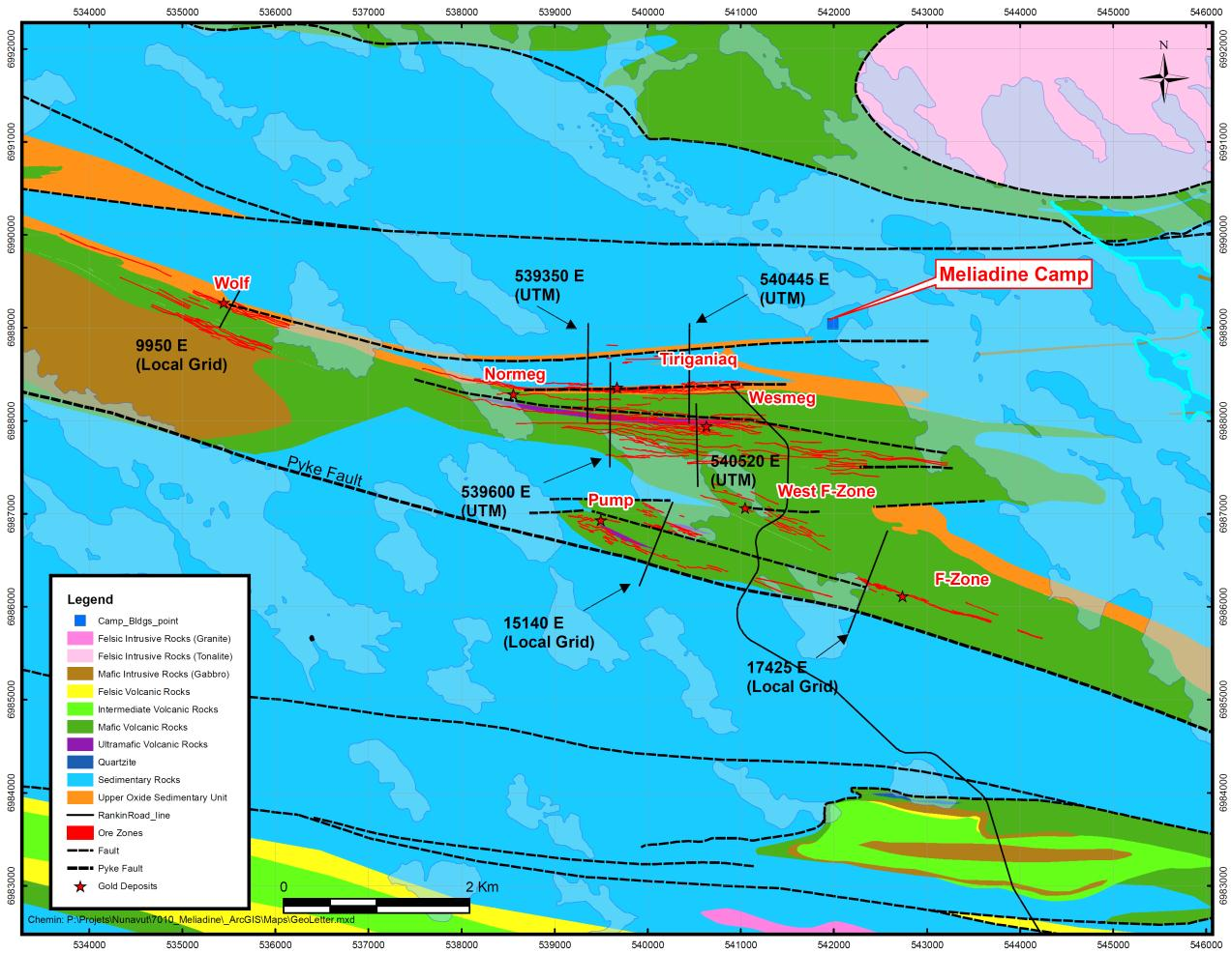
The Pyke Fault was generated by the mid-second generation deformation event, at a slightly oblique angle to the regional stratigraphy and well-developed Z-shape folds across the entire length of the property. Individual folds range from centimetre to kilometre scale and are well developed north of the Pyke Fault.
Subsequent north-south shortening during a third deformation event resulted in shears trending roughly east-west as splays off the main southeast shear trend. Gold mineralization is interpreted to have been introduced during this event, and is postulated to be Proterozoic in age (Miller et al., 1995; Carpenter et al., 2005).
The weaker mica-bearing and argillite units show late-stage crenulation of the penetrative shear fabric locally. The crenulation is thought to post-date the gold mineralization.
Local geology map showing the Tiriganiaq, Normeg, Wesmeg, F-Zone, Pump and Wolf deposits. The black lines indicate cross sections.
Deposit geology:
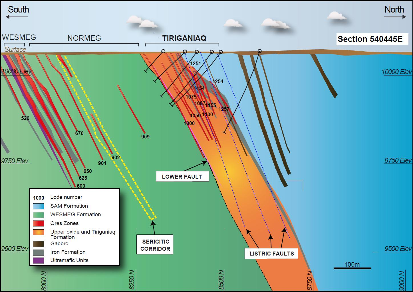
The stratigraphic sequence in the Tiriganiaq deposit area strikes east-west and dips to the north at an average of 60º. The orientation of the Tiriganiaq gold deposit is unique on the property; the rock units are aligned for more than 3 km along what is interpreted as the mineralized shear direction.
Clastic turbidites of the Sam Formation are the oldest (northernmost) rocks. Beneath is the Upper Oxide Formation, a diverse package of iron-rich rocks that includes beds of magnetite, chert, chloritic mudstone, and greywacke. The upper contact with the Sam Formation is marked by the distinct, laterally consistent “Upper Oxide Iron Formation,” which is easily recognized and traceable across the property due to its high magnetic susceptibility. Further south is the Tiriganiaq Formation of laminated siltstones.
At the base of the Tiriganiaq Formation there is sporadic black argillite that commonly underlies the 1000 lode mineralization. The Lower Fault likely formed along this obvious stratigraphic weakness. This fault defines the contact between the Tiriganiaq Formation and the underlying Wesmeg Formation of chlorite-rich massive to pillowed basalts with rare gabbro dykes and interflow sediments. The Lower Fault is the locus of intense late shearing that decreases away from the contact surface, but is more developed in the structural hanging wall. Associated faults emanating from the Lower Fault have resulted in repetition of the stratigraphy in the Tiriganiaq gold deposit.
Tiriganiaq vertical cross section at 540445E showing geology and lode wireframes:
Mineralization:
Mineralization in the Tiriganiaq gold deposit is strongly associated with shearing and quartz veining, which likely developed during the Proterozoic third deformation event. The most intense and consistent gold mineralization is present within both the Upper Oxide Iron Formation and proximal to the Lower Fault in the siltstones of the Tiriganiaq Formation, but minor amounts of mineralization have been reported in all rock types. Areas of intense shearing are ‘healed’ by quartz veining and there is generally little to no brittle deformation.
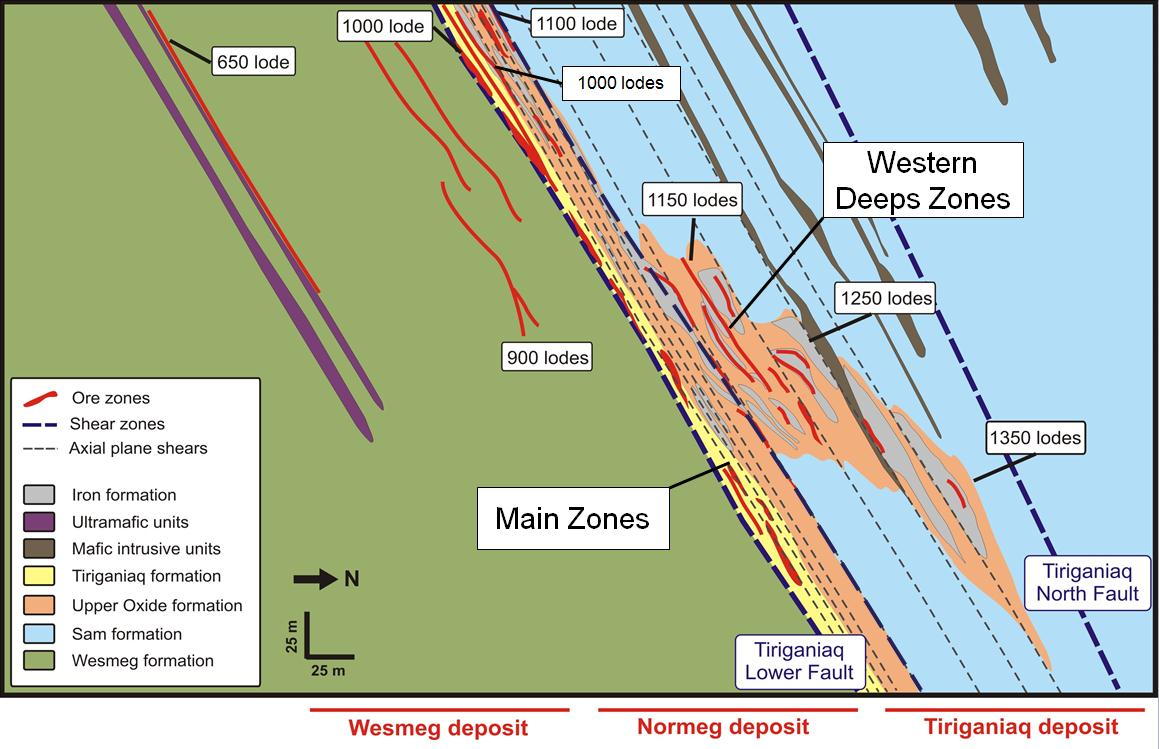
The Tiriganiaq gold deposit has been subdivided into the Main and Western Deeps zones, the latter discovered in 2000, five years after the discovery of the Main zone. Drilling in and between the zones from 2005 to 2008 indicated the Western Deeps is the western down-plunge continuation of several of the Tiriganiaq gold deposit Main zone lodes. The current interpretation is that the Western Deeps zone and Main zone lodes are all part of the same deposit.
Quartz veining
Gold mineralization is directly associated with syn- to post-deformational quartz veining. Vein appearance is highly variable from a several-metres-thick laminated vein along portions of the Lower Fault to wispy, apparently erratic quartz stringers and stockwork in the Tiriganiaq Formation. With some exceptions, quartz-only and quartz-ankerite veins tend to be mineralized with gold, while quartz-calcite veins are commonly barren in all lodes. This observation implies to multiple veining events.
Oriented drill core measurements taken in 2005 and in 2014 indicated the most prevalent vein sets measured are sub-parallel to the dominant second generation foliation across the deposit, which is predominantly sub-parallel to bedding. This style of veining is localized and best developed in areas of high strain and associated gold mineralization (e.g., the 1000 lode). Although less prevalent, a second late vein set is recognized that crosscuts the prevalent veining and dips flatly to moderately northwards. The quartz-ankerite veins in this latter set are typically narrow and infrequent, but contain visible gold. Similar to the prevalent veining, the crosscutting set is most often associated with mineralized zones of high strain, formed perhaps as ladder-style extensional veins.
Sulphides
Sulphide minerals in the Tiriganiaq gold deposit are of two distinct generations: primary and late sulphides.
Primary sulphides consist of wispy, discontinuous, bedding-parallel laminations of pyrrhotite, pyrite and chalcopyrite in oxide iron formations and black argillite. Fine-grained, web-textured sulphides in oxide iron formations close to quartz veins may represent remobilization of primary sulphides, but may alternatively signify sulphur introduced during mineralization. Gold values are generally low to absent in this sulphide assemblage, in the absence of quartz veining.
Sulphidation of the iron formation is incomplete and variable in the Tiriganiaq gold deposit, even in well-mineralized gold-bearing lodes, and is clearly not a prerequisite to significant gold values.
Late sulphides consist of coarse-grained (sub-centimetre-size) clots of arsenopyrite crystals and pyrrhotite associated with highly gold-bearing zones located in and close to quartz veining. The coarse arsenopyrite crystals rarely show signs of strain, having suffered little post-depositional deformation. Arsenopyrite of this type, in association with quartz veining, is a good visual indicator of elevated gold values.
Both primary and late sulphide assemblages host minor, local concentrations of galena and less abundant sphalerite. These minerals appear to be more prevalent in gold-rich areas in the Tiriganiaq Formation, specifically in the 1025, 1050, 1075 and 1087 lodes (see description of lodes below).
Visible gold is common in all lodes in the deposit and is present in quartz veins, pyrrhotite, and along the margins and late fractures of arsenopyrite crystals.
Alteration
Zones of significant gold mineralization that occur near the Lower Fault are associated with moderate to strong sericite hydrothermal alteration that may be tens of metres thick. This is especially apparent in Tiriganiaq Formation siltstones and Wesmeg Formation volcanics, where the intensity of alteration and deformation makes it difficult to differentiate the two units.
Sericite is present, but less well developed, in mineralized lodes in the iron formations. Chlorite and disseminated magnetite are common in the Upper Oxide Iron Formation but are interpreted to be part of the mineralogy of the silicate bands in the iron formations rather than a distinct hydrothermal alteration product.
Potassium replacement is present locally as biotite-bearing selvages in sedimentary rocks hosting mineralized quartz veins and/or iron formations.
Lodes
Gold mineralization in the Tiriganiaq gold deposit is hosted in the Upper Oxide Iron Formation as well as in clastic sedimentary and mafic volcanic rocks. It is associated with pyrrhotite- and arsenopyrite-bearing iron formation, and quartz veins with an alteration assemblage of ankerite, sericite, chlorite, and quartz.
Five dominant lodes host the gold mineralization in the Tiriganiaq deposit. These five lodes have been subdivided into a total of 35 domains for wireframe modelling and resource estimation purposes. Lode geometries, in general, fall into two basic categories: layer-parallel lodes, and plunging or non-layer-parallel lodes.
The dominant geologic control for layer-parallel lodes is a late penetrative, bedding-parallel shear system (e.g., 1000, 1015, 1025, 1050, 1075, 1087 and 1100 lodes). Two of the lodes (1000 and 1100) host significant high-grade gold concentrations over substantial widths. Geology, gold grade, alteration, mineralization and strength of structure of these two lodes are moderately consistent and predictable within the Main zone of the Tiriganiaq deposit. The overall orientation of mineralization in these two lodes suggests a moderate plunge to the east, but mineralization of economic interest is restricted to shoots of smaller size that appear to have a slight west plunge within the overall body of lower grade mineralization. The 1015, 1025, 1050, 1075 and 1087 lodes may also follow this pattern.
The main control for plunging and non-layer-parallel lodes is that they host gold in multiple sub-parallel, west-plunging shear structures such as the 1153 and 1252 lodes. These interpreted fold structures may be related to reactivated faulting and/or fold repetition of the Upper Oxide Iron Formation (the iron formation at the lower end of the 1100 lode). Many mineralized shears cut through the fold nose and the overall package plunges 10º to 20º to the west. Gold grades appear to be higher and more continuous where the shears cut the thicker iron formation in the nose of these folds.
Composite geological cross section, Wesmeg-Normeg-Tiriganiaq, showing the relative position of the lodes
1000 Lode
The 1000 lode is narrow, shear-hosted and controlled by the nearby Lower Fault. The lode is centred on a semi-continuous laminated to networking quartz-vein system that varies from centimetres to several metres in thickness and is hosted in strongly sericitized greywackes and siltstones.
The 1000 lode is tabular, averages less than 2 m in true thickness and dips 60° to the north. Slight bends in the dip of the lode surface and the associated thickening appear to be an important control on the internal distribution of mineralization. It is interpreted that localized dilation zones were created slightly above the flexures, forming favourable pathways for mineralized fluid flow and gold deposition.
As elsewhere in the Tiriganiaq gold deposit, the more gold-rich sections within the lode have strongly developed coarse arsenopyrite concentrations and visible gold. There is no consistent correlation between gold grade and the presence of quartz. The zones of best mineralization, particularly in the upper portions of the lode, tend to coincide with continuous laminated quartz veining. This observation has allowed for the interpretation of a well-defined high grade subdomain within the 1000 lode that comprises predominantly laminated quartz veining and immediately nearby high intensity, but more irregular, quartz veining.
1000 Lode Series
Located between the 1000 and 1100 lodes, the 1000 lode series are generally moderately narrow, sub-parallel, discontinuous zones of shear-controlled gold mineralization hosted in both sericitized clastic sediments and thin discontinuous iron formations oriented parallel to the 1000 and 1100 lodes.
All available geological data were used to constrain these lodes during the modelling process, including the presence and intensity of quartz veining, arsenopyrite, pyrrhotite, sericite alteration and shear intensity. Quantitative and semi-quantitative structural information collected from drill core with respect to shearing was used to define the orientation of these lodes. This orientation was largely consistent with the dominant second generation foliation across the deposit.
The most consistent geological information used to define the lodes was anomalous gold grades respecting, where possible, cut-off grades for open pit or underground mining and minimum mining widths. These gold-bearing zones are commonly spatially related, though not necessarily coincident with the above constraints. As a result, gold grades within one lode can vary significantly from one drill intercept to another. The 1000 lode was observed and thoroughly sampled by underground exposure on the 9950 Level but the controls on the localization of gold is uncertain for the other lodes. This can only be resolved by underground exposure and detailed sampling, including detailed infill drilling in all of the lodes in the 1000 series.
1100 Lode
Defined as the first significant oxide iron formation to be encountered when drilling from north to south, the 1100 lode consists of several thick, banded chert-magnetite units with variable silicate layers interbedded with several narrow siltstone and greywacke beds. The lode varies from 4 m to 12 m in true thickness, generally becoming thinner down dip. Much of the thickening is attributed to structural repetition of the iron formation through local tight folding and/or faulting.
Potentially economic concentrations of gold can encompass the entire lode, but they are commonly restricted to arsenopyrite-rich concentrations in narrow shears at the hanging-wall and footwall contacts of the Upper Oxide Iron Formation.
A poor understanding of the controls on the shearing (possibly a combination of crosscutting and bedding-parallel shearing) within the larger iron formation unit, and therefore on gold distribution, has made the selective definition of discrete higher grade portions of the 1100 lode difficult. The 1100 lode was observed over 164 m of strike length and thoroughly sampled by underground exposure on the 10,000 Level and it proved to be continuous.
1150 Lode Series
This lode series comprises nine lodes occurring between the hanging wall of the 1100 lode and the footwall of the 1250 lode in up-thrust sections of folded and sheared Upper Oxide Iron Formation. The thrusts are not clearly understood, but could be interpreted from diamond drill core interpretation to be reactivated faults emanating from the Lower Fault. The entire package of folded and fault-repeated iron formation and sediment has a shallow (±13º) plunge to the west.
The gold mineralization occurs in narrow, dominantly non-layer-parallel, and lesser layer-parallel, quartz-filled shears. These shears are broadly sub-parallel to the orientation of the folded system. Concentrations of arsenopyrite, pyrrhotite and local visible gold are common in the mineralized shears. The more continuous and wider parts of the economic zones are concentrated in the nose position in complexly folded and sheared iron formation. Mineralized shears have been divided in the resource model into subdomains labelled (from south to north): 1150, 1151, 1152, 1153, 1154, 1155, 1156, 1157, 1160 and 1170. Some appear layer-parallel while others appear to migrate from the structural footwall to the hanging wall, moving from east to west across the zone.
1250 Lode Series
The 1250 lode series is a northerly repetition of the 1150 lodes. The overall lode shape has a westerly plunge. The higher-grade gold mineralization in the lode appears to be controlled by a similar series of narrow but continuous shear zones. The shears have been subdivided in the resource model and labelled as follows (from south to north): 1250, 1251, 1252, 1253, 1254,1255, 1256, 1257, 1258, 1259, 1260, 1261, 1262, 1263 and 1264. These subdomains contain most of the gold in the Western Deeps zone of the Tiriganiaq gold deposit.
1350 Lode
The 1350 lode is a northerly repetition of the 1250 lode, interpreted as a third reactivated fault. The overall lode shape appears to have a westerly plunge, but drilling in this zone is as yet limited. The higher-grade gold mineralization in the lode appears to be controlled by a similar series of narrow but continuous shear zones with five spatially restricted domains: 1265, 1270, 1275, 1350 and 1360.
Deposit types:
The Meliadine gold district comprises a combination of orogenic greenstone- and banded iron formation (“BIF”) hosted gold mineralization. Gold in the district is associated with hydrothermally altered and sulphidized BIF (Lawley, et al., 2013).
The seven gold deposits defined on the property are vein- and shear-dominated occurrences hosted predominantly in iron formation, fine-grained sediments and volcanics, either on a splay off the regional Pyke Fault (such as the Tiriganiaq, Wesmeg and Normeg deposits) or else on structures parallel to the Pyke Fault (such as the Discovery, Pump, F zone and Wolf deposits). While these gold deposits are similar to other recognized iron formation-hosted gold deposits, such as Lupin in Canada’s Northwest Territories (e.g., Bullis et al., 1994) and Homestake in South Dakota, U.S.A. (e.g., Rye and Rye, 1974), the strong association of quartz veins with gold mineralization in sediments at Meliadine is distinct from these other deposits.
Tectonic interleaving of the Archean supracrustal rocks, together with local and regional textural and mineralogical evidence, suggest that a combination of early Archean structural preparation and later Proterozoic re-activation was responsible for the Lower Fault splay and subsequent dextral movement along it. Evidence to date suggests that the main gold mineralizing event at the Meliadine property was Proterozoic in age (Miller et al., 1995). This age is supported by a 207Pb/206Pb age of 1,854±6 million years determined on hydrothermal monazite from gold-bearing quartz veins at the Tiriganiaq deposit (Carpenter et al., 2005).
Gold mineralization in the deposits is strongly correlated with shearing and quartz veining. Mineralized lodes are hosted in quartz-vein stockwork, laminated veins and variably sulphidized iron formations, in complexly folded and sheared iron formation, sedimentary and volcanic rocks in or near the volcanic-sedimentary contact. The most important exploration targets of exploration in the project are mainly located along regional shear zones, especially where they intersect BIF. The exploration drilling therefore includes holes angled perpendicular to the regional foliation in the area of these intersections, following the mineralized shoots. Because of the scarcity of outcropping bedrock, geophysical surveys have been used to locate new targets, followed up by prospecting and limited diamond drilling.
Note:
For mineral resources and reserves (as at December 31, 2010):
- Probable reserve cut-off grades: 2.03 g/t (open pit) and 4.88 g/t (underground). The table presents combined open-pit and underground reserves. Contained gold (metric tonnes) was calculated by goldmap.info.
- Indicated resources cut-off grades: 1.83 g/t (open pit) and 2.93 g/t (underground). The table presents combined open-pit and underground resources. Contained gold (metric tonnes) was calculated by goldmap.info.
- Inferred resources cut-off grades: 3.78 g/t. Contained gold (metric tonnes) was calculated by goldmap.info.
For mineral resources and reserves (as at December 31, 2014):
- The mineral reserves are inclusive of the mineral resources
- The gold cut-off grade before dilution for open pit mining is 3.24 g/t
- The gold cut-off for underground reserves after dilution is 4.80 g/t (6.24 g/t before dilution)
- Marginal material resulting from underground development has been included in the underground mineral reserves. The marginal underground gold cut-off grade of 1.79 g/t after dilution (2.33 g/t before dilution)
- The economic diluted cut-off grades used are 2.28 g/t (open pit) and 4.80 g/t (underground), with the marginal cut-off grades of 1.8 g/t (open pit) and 1.79 g/t (underground).
- Contained gold (metric tonnes) was calculated by goldmap.info.
Mineral Resources (Dec. 31, 2010)
| Class | Ore (ktonnes) | Au grade (g/t) | Au (kg) | Au (oz * 1000) |
|---|---|---|---|---|
| Indicated | 5407.00 | 4.67 | 25241.84 | 810.00 |
| Inferred | 7883.00 | 7.55 | 59516.65 | 1913.00 |
Reserves (Dec. 31, 2010)
| Class | Ore (ktonnes) | Au grade (g/t) | Au (kg) | Au (oz * 1000) |
|---|---|---|---|---|
| Probable | 9467.00 | 8.54 | 80853.37 | 2600.00 |
Mineral Resources (Dec. 31, 2014)
| Class | Ore (ktonnes) | Au grade (g/t) | Au (kg) | Au (oz * 1000) |
|---|---|---|---|---|
| Measured | 34.00 | 7.31 | 248.54 | 8.00 |
| Indicated | 21613.00 | 6.70 | 144870.44 | 4655.00 |
| Inferred | 2402.00 | 9.59 | 23035.18 | 740.00 |
Reserves (Dec. 31, 2014)
| Class | Ore (ktonnes) | Au grade (g/t) | Au (kg) | Au (oz * 1000) |
|---|---|---|---|---|
| Proven | 34.00 | 7.31 | 248.54 | 8.00 |
| Probable | 13649.00 | 101924.99 | 3278.00 | 3278.00 |
Source:
-
Updated Technical Report on the Meliadine Gold Project, Nunavut, Canada
(12.03.2015, Toronto)
Authors: Connell Larry, Petrucci François, Larouche Julie, Caron Denis, Laflamme Dany, Robichaud François, Proulx Alexandre -
Technical Report on the December 31, 2010, Mineral Resource and Mineral Reserve Estimate,
Meliadine Gold Project
(16.02.2011, Nunavut)
Authors: Duquette Dyane, Matte Pierre, Caron Bertho, Connell Larry, Fournier Julie, Petrucci François