Tagged with "sill"
Regionalgeology
- Kuskokwim basin The Kuskokwim basin is predominately underlain by the Upper Cretaceous Kuskokwim Group, a back-arc continental margin basin fill assemblage that form…
- Dayohessarah Greenstone Belt The Dayohessarah Greenstone Belt of late Archean (ca. 2.7 Ga) age is located in the AbitibiWawa Subprovince of the Superior Province. The Dayohessara…
Deposit
- Каральвеемское Россия, Чукотский автономный округ. Расположено в 18 км от города Билибино, административного центра Билибинского района, в бассейне реки Малый Анюй …
- Donlin USA, Alaska. The Donlin deposits are situated approximately 280 miles (450 km) west of Anchorage and 155 miles (250 km) northeast of Bethel up the Ku…
- Sugar zone Canada. The Sugar Zone Property is located 30 km northeast of the town of White River in northern Ontario. White River is located on Trans-Canada Hig…
- Нони Россия, Хабаровский край, лист M-53-XIII. Отроги Верхнебуреинского хребта, верховья реки Кевыты (приток реки Гуджал), верховья ручья Шумный. Месторо…
- Bulldog Located in the Abitibi region, in the Bourlamaque and Louvicourt Townships, approximately 8 km southeast of the city of Val-dOr in the province of Qu…
- Marban Canada, province of Quebec. The deposit is located in the western portion of the province, about midway between the towns of Val-d’Or and …
Image
-
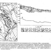 Геологическая карта и разрез Кубакинского месторождения
-
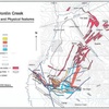
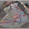
 Regional Geology of Central Kuskokwim Area
-
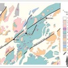
 Interpreted Property-Scale Igneous Rocks
-
 Interpreted Surface Geology of Resource Area
-
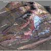
 Bench Level Geology
-
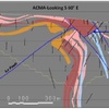 Acma area section Donlin deposit.
-
 Sierra Madre Occidental stratigraphy
-
 Сиенит
-
 Сиенит-порфир
-
 Силл сиенит-порфиров