Paiol
Phase: Exploration
Tags: actinolite albian albite ankerite archean bif calcite carbonaceous chlorite epidote granite granodiorite greenstone belt monzodiorite monzogranite mylonite paleoproterozoic phyllite potassic alteration proterozoic pyrrhotite quartz diorite quartzite saprolite schist sericite silicification tonalit tourmaline trondhjemite
The Paiol deposit is in the south-central region of Tocantins State, Brazil. The deposit area lies south of Almas (population 7,000), a small town approximately 300 km southeast of Palmas, the Tocantins State Capitol and 45 km west of Dianópolis, a regional commercial center. The Almas town site is accessed by State Highways TO-010, TO-070 and TO-050 from the state capital of Palmas, via Porto Nacional to Natividade – a trip of approximately four hours by car. Palmas, the capital city of Tocantins State (population 306,000) has all the major facilities for industrial support as well as State governmental agencies. Palmas supports a regional airport with scheduled commercial service departing several times a day to Brasilia and São Paulo. The principal commercial center in the Almas region is Dianópolis, 45 km east of the Almas town site. There are commercial flight options from Barreiras airport, with flights to Brasília, Belo Horizonte and Salvador. Barreiras is about four hours by car to Almas. Barreiras (population of 156,000) and Luiz Eduardo Magalhães (population of 90,000), located east of Almas, with distances of 280 and 190 km respectively., On the BR-242 and TO-040 highways, are cities with good infrastructure, service companies, commerce and industries. From the city of Almas, the three target areas may be reached by all-weather gravel roads, well maintained by the local government. The 17 km distance from Almas to the Paiol mine is traversed by light vehicle in approximately 20 minutes. Almas may also be reached by chartered aircraft as the local government maintains a small gravel airstrip south of the town site. At present, there is no rail service into the Almas area.
History:
Gold mining in the Almas area began in the 1700s during colonial times when slave labor was used to extract gold from near-surface oxide zones. In more recent times, garimpeiros (artisanal miners) expanded the earlier excavations. In 1977 the exploration arm of VALE identified some potentially prospective volcano-sedimentary sequences of Archean age in the region. Further exploration by VALE in the mid- to late-1980’s led to discoverie at Paiol. In 1996, VALE commenced mining at the Paiol deposit.
Gold has been the primary target of exploration in the district. Discoveries thus far, have been made by a combination of mapping and soil sampling, followed by drilling. To date, exploration has primarily targeted near-surface gold anomalies and is therefore still in the early stages. The major exploration milestones are highlighted below:
1985: VALE and METAGO, agreed to jointly explore the area.
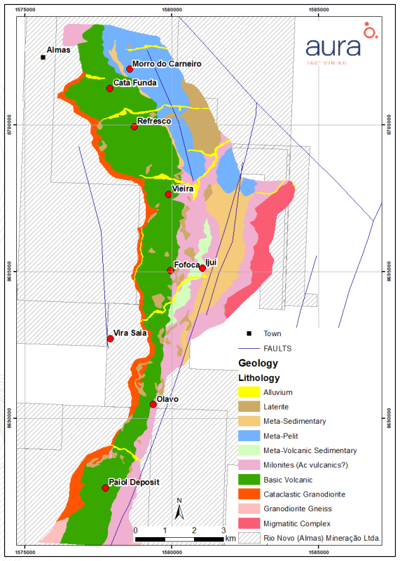
1985 to 1987: Several targets were identified during this phase of exploration: Paiol, Cata Funda, Vira Saia, Morro do Carneiro, Refresco, Vieira, Ijuí, Mateus Lopes and Cemitério.
1986: Initial drilling and discovery of the Cata Funda deposit.
1987: Discovery of Paiol deposit.
1996: VALE reports initial resource estimates for the Paiol deposit.
1996 to 2001: VALE conducts mining of the Paiol deposit.
2006 – Mineração Apuã commences exploration.
2008 to 2010: Rio Novo conducts confirmation drilling, resulting in a resource estimate, reported as an NI 43- 401 Technical Report in February 2010.
2010 to 2011: Core drilling initiated by Rio Novo for confirmation and expansion of the Paiol and Cata Funda resource areas as well as exploration of nearby targets.
2011: Discovery of the Vira Saia deposit 5 km north of Paiol
2011 to 2012: Infill drilling and resource modeling at Vira Saia brought additional resources and enhanced the overall Almas Gold Project, leading to completion of a Preliminary Economic Assessment (PEA) in March 2012.
2013 & 2016: RPM completed two feasibility study level reports (NI 43-101).
Regional geology: Tocantins Structural Province
The Tocantins Structural Province (TSP), located in the central region of Brazil, constitutes a system of Brazilian orogens, characterized by folding and thrusting belts called the Brasília, Paraguay and Araguaia Belts, resulting from the convergence and collision of three continental blocks: Amazonian Craton, to the West; Cráton São Francisco, to the East; and Cráton Paranapanema, to the Southwest, covered by the rocks of the Paraná Basin, this one with its limits inferred through gravimetric data. The foundation of the province is composed of Archaean and Paleoproterozoic terrains reactivated during the Brazilian Cycle (Delgado et al., 2003). In the final stages of the Brazilian Cycle, the gravitational collapse, exhumation and / or extrusion of the orogens, which occurred up to the Upper Ordovician have been related as a transition stage between conditions of active convergent tectonics to conditions of intraplate stability, with the beginning of the Paleozoic basins.
These phanerozoic coverings, in almost all Paraná, Parnaíba, Bananal and Pantanal Mato-Grossense basins, hide large parts of this system.
The TSP is compartmentalized in the Cráton São Francisco for small exposures of the basement and the extensive sedimentary coverings, Brasília Belt, built on the west side of the craton, divided into Zones Internal …
Local geology:
Deposit is situated in an historical gold mining area with numerous small artisanal mines (garimpos). Gold occurs in sheared metavolcanic rocks within the greenstone sequence, as well as in sheared felsic intrusive rocks. The rocks are, in general, Paleo-Proterozoic in age (~2.2 billion years old) and have undergone regional metamorphism ranging in intensity from greenschist- to amphibolite-facies. The metamorphism resulted in deep-seated, shear-hosted, mesothermal, gold deposits which have more recently been referred to as orogenic gold deposits. The gold-mineralized zone occurs in the core of hydrothermal alteration zones, generally associated with variable amounts of quartz, carbonate, albite, sericite and sulphide minerals.
The Almas-Dianópolis terrane, in the Western block of Goiás Massif, comprises several narrow greenstone belts surrounded by granite-gneiss complexes. The volcano-sedimentary sequence of Riachão do Ouro Group is composed at the base by the Córrego do Paiol formation and at the top by the Morro do Carneiro formation. Late granitic intrusions cut the supracrustal sequence. These rocks were metamorphosed to amphibolite facies during a regional tectonic-metamorphic event (Dn) and then retrogressively altered to greenschist facies assemblages, followed by a subsequent hydrothermal alteration phase linked to late strike-slip shear zone events (Dn+1).
Córrego do Paiol Formation is composed of dominant metabasalts, locally pillowed, and rare small occurrences of ultramafic metavolcanic rocks. The metabasalts are essentially massive dark green fine-grained amphibole-plagioclase-chlorite-epidote schists. Moreover, at contacts with granitoids actinolite schists are present, probably as a result of contact metamorphism. Ultramafic rocks are tremolite-chlorite schists that crop out near Dianópolis. These metabasalts correspond to high-Fe tholeiites. The ultramafic volcanic rocks are high-Mg tholeiites with komatiitic affinity. The pillowed metabasalts are indicative of a submarine deposition.
The upper Morro do Carneiro Formation consists mainly of a monotonous seqence of sericitic phyllites with carbonaceous material rich layers and more rarely chlorite-bearing layers. It also includes beds of variable thickness of more abundant hematite-magnetite banded iron formations; quartzites with magnetite bearing layers; tourmaline quartzites; and metacherts. Iron formations and metacherts are exposed near the contact with the Córrego do Paiol Formation South of Almas.
The granitoids are classified into two suites differentiated by their predominant mafic mineral. Suite 1 is comprised of hornblende-predominant tonalites, granodiorites, trondhjemites, quartz-monzodiorites and quartz-diorites. Suite 2 is composed of biotite-predominant tonalites, trondhjemites, granodiorites and monzogranites. Both suites have calc-alkaline tonalitic-trondhjemitic chemical affinities.
The most notable structural feature of Terreno Almas-Dianópolis is the distribution of greenstone belts and granite-gneiss complexes. Costa et al. (1976) were the first to recognize the Y-shaped distribution of the belts, mainly linear, in the North-South direction with branches to the Northeast and Northwest. They also have curved contacts around the granite-gneissic complexes. The complexes have geometry partially obliterated by directional shear zones that truncate the geological contacts and affect the metasedimentary rock coverings of the Natividade, Paranoá and Araí groups, the oldest structures generated in the Dn event present, in greenstones, a subvertical schistosity with features shear locations, which tend to be parallel to the contour between greenstones and granite-gneissic complexes, tight vertical folds and sub horizontal mineral lineation.
Younger structures include directional shear zones Dn + 1 with distal movement of main direction N20-30E and subsidiary directions N0-10E and N10-20W. These Dn + 1 shear zones have been related to the evolution of the Almas-Dianópolis Terrain. Dn_1 shear zones were not observed in the rocks of the Bambuí and Natividade groups in the region. Two other directions of shear zones are observed N35-50W with sinistral movement and N40-65E with distal movement, forming a conjugated pair resulting from East-West compression. The greenstones are arranged in the directions N10-35E, N10-20W, N45W and NS.
The structural control of the mineralization in the Almas-Dianópolis Gold District is the most important control factor. In most cases gold is concentrated on second and third order structures located near regional deformation zones, especially the transcrustal zones.
- Most gold bearing structures present a brittle-ductile nature but can be from different styles:
- Brittle-ductile reverse fault zones, from low to high angle.
- Fracture sequences, stockwork systems or brecciated zones in competent rock.
- Foliation with cleavage zones.
- Fold hinge zones and associated reverse faults in tight folds.
Alteration zones are symmetrical with respect to the shear zones, typical of classic greenstone alteration, including: chloritization (distal zone), sericitization (potassic alteration) and silicification, widespread carbonatization and sulphidation (pyrite and/or pyrrhotite) (proximal zone). These alteration zones are developed around shear zones cutting the mafic-to-intermediate volcanic and volcaniclastic rocks previously affected by amphibolite facies metamorphism. The hydrothermal alteration presents more lateral than vertical variation within the mineralization structures.
Gold mineralization is found in three groups of rocks, in metabasalts of the Córrego Paiol Formation, in metasedimentary rocks of the Morro do Carneiro Formation and in granite-gneiss complexes.
Several occurrences of gold are hosted in the metabasalts, mainly south of Almas, the most important being that of the Córrego Paiol mine. The occurrences hosted in metasedimentary rocks are dominant in the southern portion of the terrain, Conceição do Tocantins region, while the occurrences in granite-gneissic rocks are distributed throughout the granite-greenstone terrain.
Gold in the Almas Greenstone Belt occurs in three different associations:
- Gold associated with hydrothermally-altered shear zones in basic to intermediate volcanic rocks;
- Gold associated with hydrothermally-altered banded iron formation;
- Gold associated with smoky quartz veins in sheared granite gneiss.
Gold mineralization is closely associated with mylonitic banding in shear zones that cut mafic-to-intermediate volcanic rocks, schists and granite-gneiss, the latter being noted at the Vira Saia deposit. Gold occurs as free gold and as gold inclusions within sulfide minerals. The stronger gold mineralization is associated with faults and shear zones.
The structural control of mineralization at the Paiol and Cata Funda deposits is related to strike-slip shear zones (Dn+1 event) and later remobilization into radial, brittle-ductile zones (Dn+2 event) (Ferrari & Choudhuri 2000). The ore shoots are believed to have formed where the mylonitic foliation (Sn+1.) is cut by extensional brittle faults of the Dn+2 event (Ferrari and Choudhuri 1999a). These faults possibly served as conduits for the transport of gold-rich hydrothermal fluids
District Geology of the Almas Belt showing Garimpos:
Deposit geology:
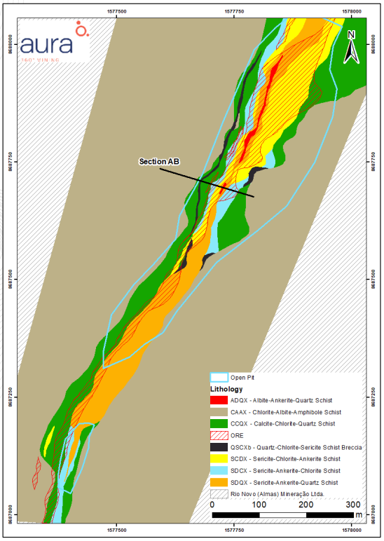
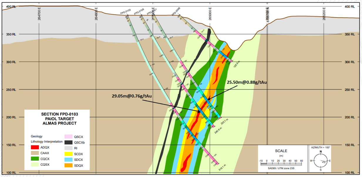
The Paiol deposit is in the middle portion of the Almas Belt, approximately 500 m east of the metabasalt/ intrusive contact. The metabasalts that host mineralization display a primary foliation of 280° azimuth with a 65° dip. The mineralization is a result of hydrothermal alteration processes controlled by shear zones. Based on the drilling data, the altered rocks form a trend at least 1,400 m long, varying from 40 m to 140 m wide from South to North, respectively.
The mineralization is continuous and confined to certain parts of the hydrothermal alteration package. The higher potential of the deposit is in the north-central part of the deposit where an intersection between the main shear zone and a secondary north-south shear zone has been interpreted.
Hydrothermal alteration assemblages at Paiol show a symmetrical zonation inward from the margin to the center of the structure: chloritization, sericitization, carbonatization, albitization and silicification. Sulfide minerals occur as millimetric to sub-millimetric grains, not exceeding more than 5% by volume.
The paragenesis of hydrothermal minerals is represented by chlorite, sericite, ankerite, calcite, albite, quartz, pyrite, (pyrrhotite) and rare tourmaline - epidote. Locally, late stage calcite-pyrite veinlets represent the final stage of alteration. The alteration paragenesis is syn-to-late-orogenic, suggesting that hydrothermal events were concomitant with tectonism.
The main Paiol ore body has overall dimensions of approximately 650 m in the down dip direction, 1,300 m along strike and averages 27 m in thickness. Overlying bedrock is 1 to 5 m of brick red, argillaceous soil with sparse, weakly magnetic, pisolites. Beneath the soil horizon is 12 to 35 m of light red, yellow to ocher-colored saprolite, locally mottled and kaolinized.
Locally relict textures and zones of deeply weathered rock may be preserved in the saprolite zone. The saprolite overlays 2 to 15 m of weathered and oxidized bedrock containing Mn-oxide minerals in fractures and on foliation planes. Locally boxwork texture after sulfide minerals is noted.
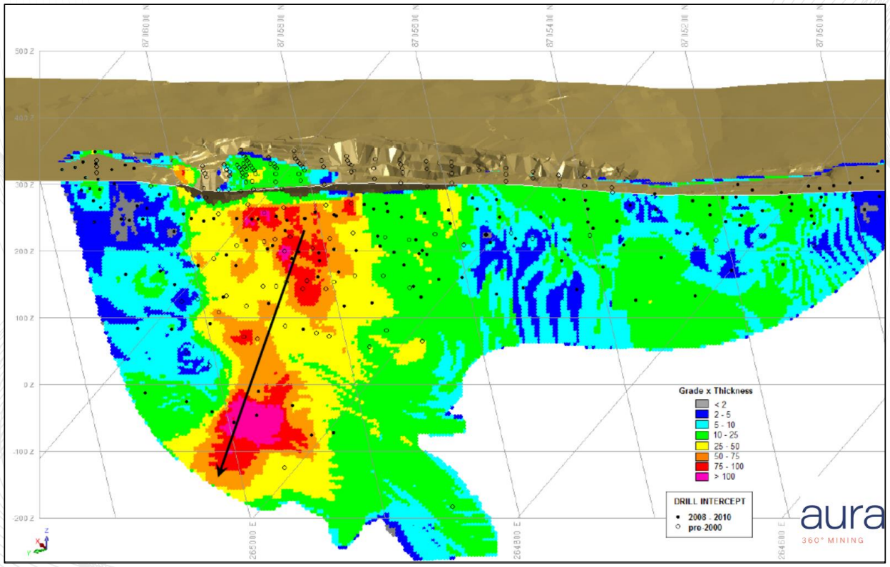
The Paiol geological map was compiled by surface projection of drilling data displayed on cross sections of which. The map shows the continuity of the mineralization from North to South where the main alteration assemblage of albite-ankerite-quartz schist represents the center of the hydrothermal system, indicated in red. The cross sections show the thickness of the Paiol Deposit, with significant intersections with high-grade at greater depth (below 350 m).
Geological Map:
Geologic Cross Section A-B of Paiol Deposit:
Geologic Cross Section of Paiol Deposit:
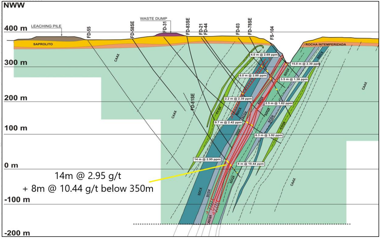
Grade-thickness section of Paiol Deposit:
Note:
Mineral Resources have an effective date of December 31, 2020.
The Mineral Resource Estimate is based on an updated optimized pit shell using US$1,800/oz gold and at a cut-off grade of 0.29 g/t gold.
A density default model based on rock type was used for volume to tonnes conversion with averaging 2.66 tonnes/m3.
Mineral Resources are inclusive of Mineral Reserves.
The Mineral Reserve Estimate is based on an updated optimized shell using 1,500 $/oz gold price, average dilution of 20% , mining recovery of 100% and break-even cut off grades of 0.29 g/t Au.
Surface topography based on December 31st, 2016.
Mineral Resources (Dec. 31, 2020)
| Class | Ore (ktonnes) | Au grade (g/t) | Au (kg) | Au (oz * 1000) |
|---|---|---|---|---|
| Measured | 4366.95 | 1.03 | 4497.96 | 144.87 |
| Indicated | 13181.19 | 0.96 | 12653.94 | 407.59 |
Reserves (Dec. 31, 2020)
| Class | Ore (ktonnes) | Au grade (g/t) | Au (kg) | Au (oz * 1000) |
|---|---|---|---|---|
| Proven | 5357.97 | 0.89 | 4768.60 | 152.68 |
| Probable | 10780.50 | 0.88 | 9486.84 | 304.45 |
Source:
-
Updated Feasibility Study Technical Report (NI 43-101) for the Almas Gold Project
(10.03.2021, Almas)
Authors: F. Ghazanfari, L. Pignatari, I. Dymov, P. C. Rodriguez, A. Wheeler, Hennessey Terrence, Raponi Tommaso Roberto