Discovery
Mine Type: Pit, Underground
Tags: archean arsenopyrite basalt bif biotite calcite chalcopyrite chlorite gabbro greenstone belt hornblende proterozoic pyrrhotite sphalerite turbidites
The Meliadine gold project (including the Discovery deposit) is located in the Kivalliq District of Nunavut in northern Canada, approximately 25 km northwest of Rankin Inlet on the west coast of Hudson Bay. A private all-weather access road constructed by Agnico Eagle connects Rankin Inlet to the Meliadine project. The current Meliadine exploration camp is located on the shore of Meliadine Lake, approximately 2.3 km east of the Tiriganiaq deposit.
The physical features of the Meliadine region have largely been determined by glaciation. The terrain consists predominantly of broadly rolling uplands and lowlands with little topographical relief (very few hills). Rankin Inlet is located on the shore of Hudson Bay with a mean elevation of 28 m above sea level. Strung out across the landscape are long, sinuous eskers. This undulating landscape is studded with innumerable lakes, ponds, and wetlands. Cryosols are the dominant soils, and are underlain by continuous permafrost with active layers that are usually moist or wet throughout the summer.
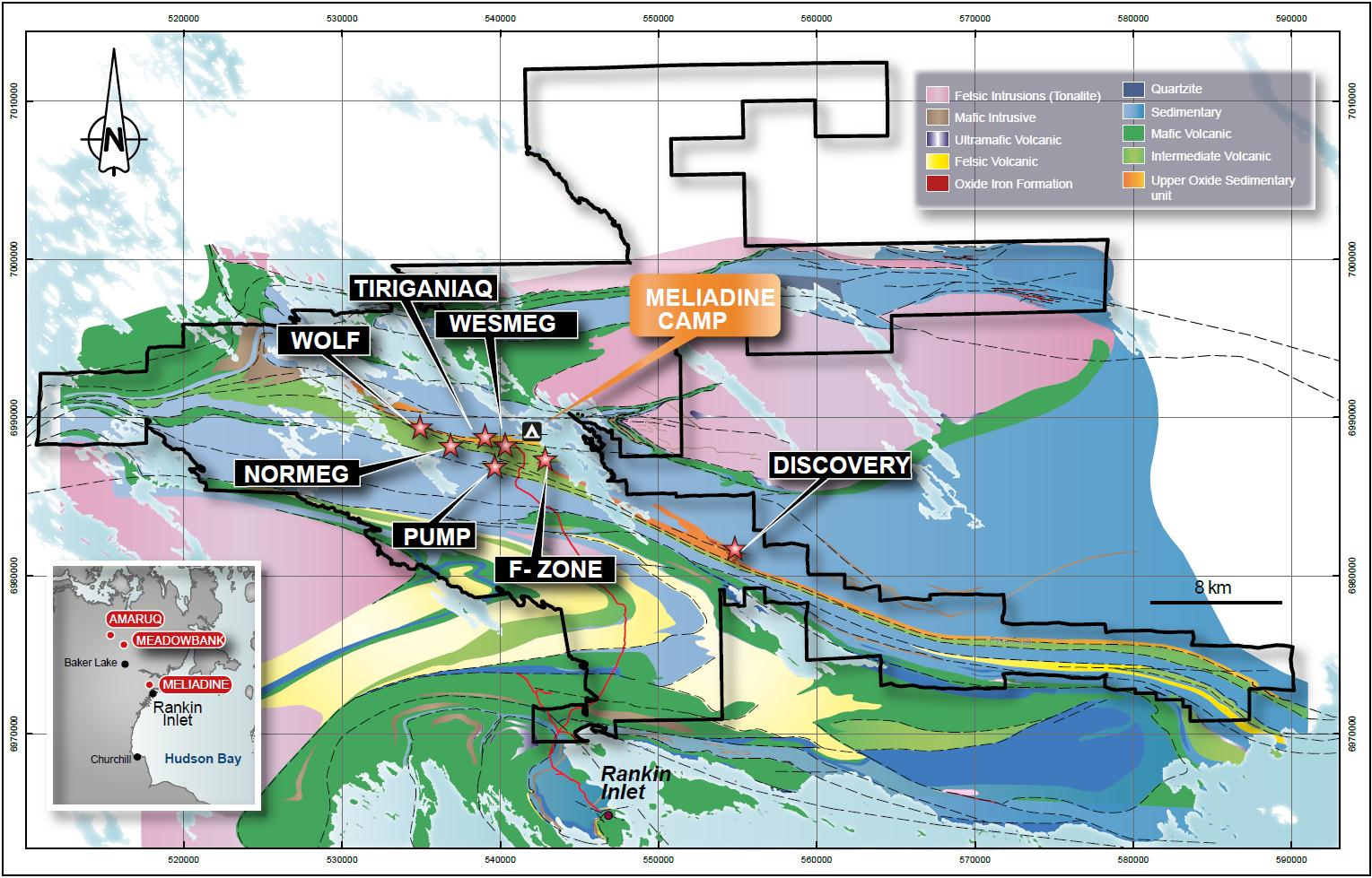
Regional geology: Rankin Inlet Greenstone Belt
Located in the Northwest Hearne Sub-domain of the Churchill Structural Province that forms part of the northern Canadian Shield. Supracrustal rocks of this belt consist of mafic volcanic rocks, felsic pyroclastic rocks, sedimentary rocks and gabbro sills of about 2.7 billion years old that have been polydeformed and metamorphosed (Bannatyne, 1958; Laporte, 1983; Tella et al., 1986; Tella, 1994).These rocks were deformed in both the Archean and Proterozoic eras.
Meliadine area regional geology:
Local geology:
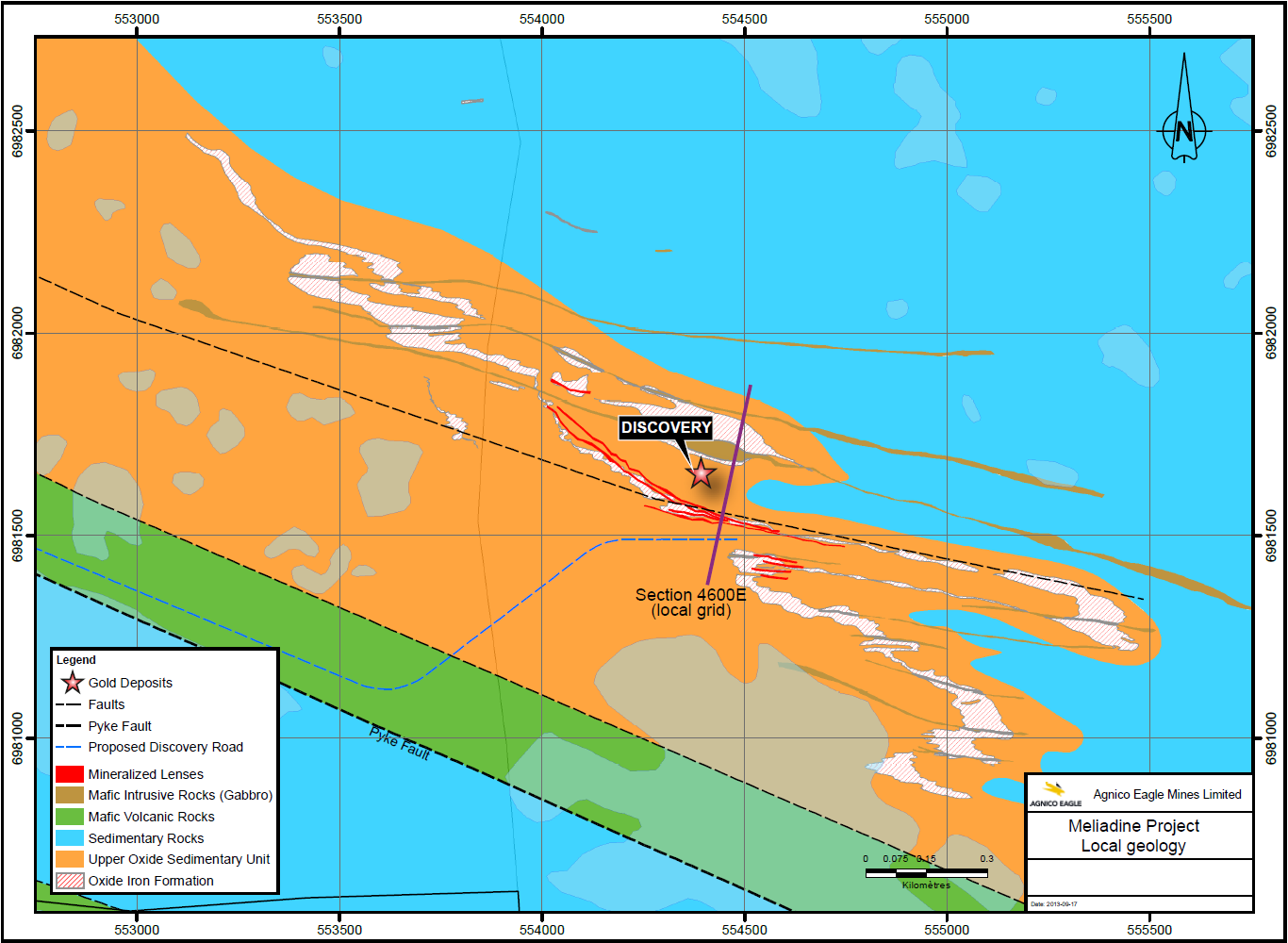
Local geology map showing the Discovery deposit area. The purple line indicates a cross section.
Deposit geology:
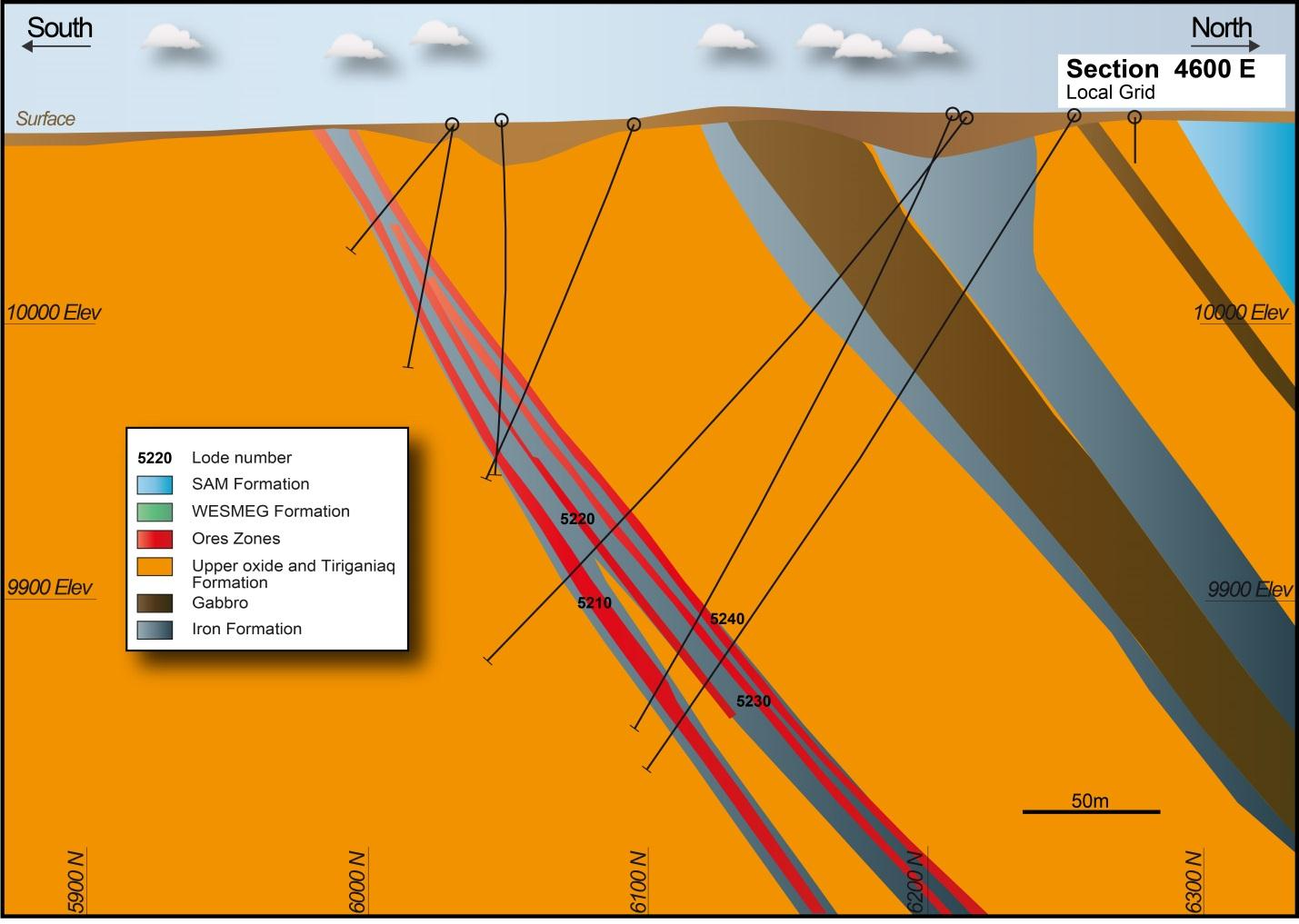
The stratigraphic sequence in the Discovery deposit area strikes northwest-southeast and dips from 45º to 60º to the north.
Clastic turbidites of the Sam Formation are the oldest (northernmost) rocks. As at Tiriganiaq, these overlie the Upper Oxide Formation and its uppermost portion, the “Upper Oxide Iron
Formation”. Chlorite-rich massive to pillowed basalts of the Wesmeg Formation form the structural footwall to the sequence but occur at least 600 m south of the Discovery deposit. The Lower Fault forms the contact between the Wesmeg and Upper Oxide formations and is interpreted as a basal detachment surface but in the area of the Discovery deposit it is not
exposed and has not been drilled so far. The Lower Fault therefore represents a potential target for Tiriganiaq-style lode gold vein zones similar to the 1000 lode.
The Upper Oxide Iron Formation hosts most of the gold mineralization at Discovery. It is strongly folded with most of the thicker and more continuous mineralization following the fold
noses, which plunge to the east-northeast at 47°.
Discovery vertical cross section at 4600E (local grid) showing geology and lode wireframes (indicated by red ore zones):
Mineralization:
Mineralization in the Discovery gold deposit is strongly associated with shearing and quartz veining within the Upper Oxide Iron Formation, which is strongly folded. The thicker, higher-gold-grade sections are controlled by Z-shaped folds that trend east-northeast and plunge 47º.
Free gold occurs as coatings and fracture fillings in large recrystallized arsenopyrite and pyrrhotite grains, and as disseminations in quartz veins and chlorite layers. Trace amounts of
sphalerite and chalcopyrite are found locally.
Alteration envelopes occur adjacent to quartz-calcite veining and are characterized by hornblende/grunerite-, biotite- and calcite-bearing assemblages that overprinted the pre-existing regional greenschist metamorphic facies.
Note:
History, local geology, deposit geology, and deposit type are described under the Tiriganiaq deposit.
For mineral resources and reserves (as at December 31, 2010):
- Inferred resources cut-off grades: surfase to 9,960 m elevation - 2.61 g/t; below 9,960 m elevation - 6.0 g/t.
- Indicated resources cut-off grades: surfase to 9,960 m elevation - 3.0 g/t; below 9,960 m elevation - 5.22 g/t.
- The table presents combined resources.
- Contained gold (metric tonnes) was calculated by goldmap.info.
For mineral resources and reserves (as at December 31, 2014):
- The mineral reserves are inclusive of the mineral resources
- The table presents combined open-pit and underground resources (calculated by goldmap.info)
- The gold cut-off grade for open pit mining is 2.73 g/t
- The gold cut-off for underground reserves is 4.14 g/t
- Contained gold (metric tonnes) was calculated by goldmap.info.
Mineral Resources (Dec. 31, 2010)
| Class | Ore (ktonnes) | Au grade (g/t) | Au (kg) | Au (oz * 1000) |
|---|---|---|---|---|
| Indicated | 1322.00 | 7.41 | 9794.50 | 241.00 |
| Inferred | 498.00 | 8.97 | 4467.50 | 217.00 |
Mineral Resources (Dec. 31, 2014)
| Class | Ore (ktonnes) | Au grade (g/t) | Au (kg) | Au (oz * 1000) |
|---|---|---|---|---|
| Indicated | 2517.00 | 5.84 | 14707.20 | 473.00 |
| Inferred | 529.00 | 7.55 | 3993.95 | 128.00 |
Source:
-
Updated Technical Report on the Meliadine Gold Project, Nunavut, Canada
(12.03.2015, Toronto)
Authors: Connell Larry, Petrucci François, Larouche Julie, Caron Denis, Laflamme Dany, Robichaud François, Proulx Alexandre -
Technical Report on the December 31, 2010, Mineral Resource and Mineral Reserve Estimate,
Meliadine Gold Project
(16.02.2011, Nunavut)
Authors: Duquette Dyane, Matte Pierre, Caron Bertho, Connell Larry, Fournier Julie, Petrucci François