Norlartic
Phase: Exploration
Mine Type: Pit, Underground
Tags: actinolite albitization andesite archean basalt calcite carbonatization chlorite diorite dyke granodiorite greenstone belt komatite stockwork
Canada, province of Quebec. The deposit is located in the western portion of the province, about midway between the towns of Val-d’Or and Malartic.
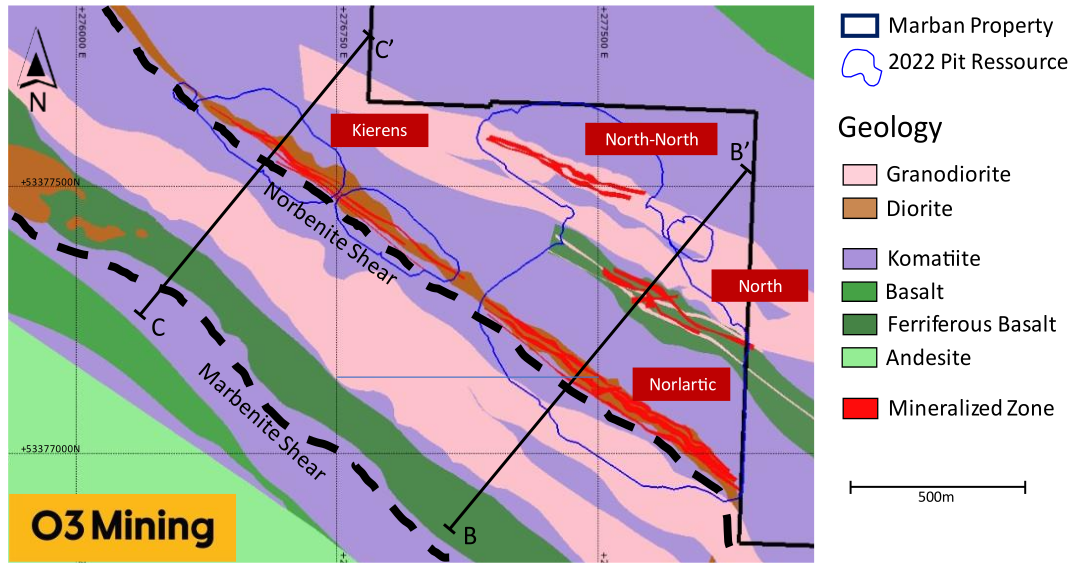
Located on the north side of Highway 117, approximately 15 km northwest of Val-d’Or, Quebec and immediately east of Canadian Malartic Partnership’s Camflo property. The project is accessible by the Gervais Road, a well-maintained all-weather gravel road running north from Highway 117. It provides access to the historic Norlartic, Kierens, and Marban mines. The Camflo road provides access to the western part of the project area. Winter access for snowmobiles and all-terrain vehicles is provided by trails and winter roads.
History:
Estimated historical gold production: Norlartic Mines - 1959-1966; Aur Resources - 1990-1992. Total: 1544 kt ore, Au grade - 4.2 g/t, Au ounces*1000 - 209.
Exploration:
- Pre-1943. Five surface drillholes in the NE corner of Lot 2, Vassan Township.
- 1943–1946. Norbenite Malartic Mines. Sixty-six drillholes totaling 12,075 metres that resulted in the discovery of the Main Zone of the future Norlartic mine.
- 1946. Norbenite Malartic Mines. Hole NM-65 was drilled in 1946 that tested the large granodiorite sill located north of the Gold Hawk Horizon. The best assay from this hole was 1.71 g/t Au over 1.5 m.
- 1946–1948. Norbenite Malartic Mines. Three-compartment shaft sunk at the Norlartic mine to 165 m. A total of 1508 m of drifting on 38-, 76-, 114-, and 152-m levels, cross-cuts totaling 542 m, and raises totaling 160 m. Underground drilling totaling 4,208 m.
- 1950. Norlartic Mines Ltd. Discovery of the North Zone in July during a surface drilling program.
- 1950–1951. Norlartic Mines Ltd. Shaft dewatering and resumption of underground exploration at Norlartic mine. Extraction of a 22,680-t bulk sample.
- 1958. Norlartic Mines Ltd. The Norlartic property remained inactive until 1958, at which time Malartic Goldfields gained control of Norlartic Mines Ltd.
- 1959–1966. Norlartic Mines Ltd. Production at the Norlartic mine and shaft dewatering and deepening to 320 m. Development of the 190-, 228-, 266-, and 305-m levels. Production started in mid-December 1959 for a 7-year period. Total mine production of 1,076,823 t at 4.46 g/t Au yielding 145,610 ounces of gold and 15,189 ounces of silver, including approximately 45,000 tonnes from the Kierens Zone on the First Canadian property [MDA notes that the total mine production exceeds that reported in Norlartic Mines records provided to MDA]. Ore was mined from two shoots (A and B Zones) above the 152-m level. Exploration was conducted below this level but was limited to 9 holes directly below the workings to a depth of 195 m. Only one of these holes hit ore-grade mineralization. An additional 9 holes were drilled east of the workings above the 152-m level. Mining was apparently carried out on a salvage basis in the western portion of the deposit, and it appears that stoping and drifting terminated in high-grade material.
- 1963. Norlartic Mines Ltd. Hole NS-99 drilled, which apparently cut part or all of the Gold Hawk Horizon, although no drill logs or assays have been preserved.
- 1966–1973. Ownership changed to Willroy Mines Ltd., and then to K. Wheeler and L. Harvey in 1966. Corvel Securities later optioned the ground.
- 1973–1975. First Canadian Gold Corp. Acquisition of Norlartic by First Canadian. Magnetometer survey and 33 surface holes totaling 4,166 m at the North-North Zone.
- 1979–1981. Brominco Inc. Acquisition of Norlartic by Brominco. Line-cutting and magnetic + VLF surveys. Surface diamond drilling of 62 holes for 6,478 m, including 36 holes (3,757 m) at the Main Zone and 26 holes (2,720 m) at the North-North Zone.
- 1984. Brominco Inc. Line cutting, property-scale surface magnetic and VLF-EM surveys, and three diamond drillholes. Compilation of existing geotechnical data.
- 1985–1986. Aur Resources. Brominco was merged with Aur shortly before the 1985–86 program. Aur carried out a 21-hole diamond-drilling program totaling 5,675 m in the northern part of the property. The main purpose of the program was to re-evaluate the economic potential of the Kierens Zone and to establish additional drill-indicated reserves. A 4,452-m surface drilling program completed at the North Zone. The drilling was concentrated in the area to the east and below the old workings. Several ore-grade intersections were obtained up to 7.85 g/t Au over 3.8 m, but the gold distribution was found to be erratic. Single vertical hole, 2001-52, tested Marban shear. The upper part of this hole intersected the footwall portion of the Gold Hawk Horizon , which contained some minor quartz veining with anomalous gold values up to 0.34 g/t Au over 1.5 m. The best assay from this hole was 0.41 g/t over 1.5 m, which occurred in strongly sheared talc-chlorite schists interpreted to be the Marban Shear. The Norlartic shaft was dewatered and rehabilitated in order to re-evaluate the potential of the Main Zone. Drilling of geotechnical holes (2001-53 to 2001-92) to monitor the behaviour of the hanging wall rocks during dewatering. Six holes totaling 356 m were drilled into the North Zone stopes; one of these (2001-75) returned 19.41 g/t Au over 14.9 m (7.6-m true width). Shortly thereafter, nine exploration holes (2001-93 to 2001-101) were drilled, four of which re-tested the area directly west of the old stopes between vertical depths of -76 m and -213 m. These holes returned intersections ranging from 3.12 g/t Au over 1.5 m to 7.2 g/t Au over 3.05 m.
- 1987. Aur Resources. Hole 2001-106 was drilled on section 20+00W, approximately 365 m west of the nearest existing information, to test the Norbenite Shear at depth. This hole traversed the expected extension of the North Zone at a depth of approximately 122 m, but neither the mafic volcanic package nor the North Zone style of mineralization was encountered.
- 2010–2011. NioGold Aurizon. Phase I Program that included 24 holes at the Norlartic deposit.
- 2014. NioGold. Four (4) holes were drilled at Kierens and 6 at Norlartic (representing 1,646 m and 1,368 m respectively)
- 2015–2016. NioGold. Twelve (12) PQ-sized holes totalling 1,692 m, drilled for comminution tests on Norlartic, Kierens, and Marban deposits.
- 2016–2017. Osisko Mining. Twenty-six (26) holes testing down dip extension of the Marban, Norlartic and Kierens deposits totaling 15,171 m
Discovered in 1943–1944, the Norlartic Main zone was developed in 1946 through 1948, when Reserves were estimated at 544,320 tonnes grading 5.83 g/t Aug (102,000 ounces) in the Main zone above the 152-m level. In the early 1950s, the North Zone was discovered 365 m north of the Norlartic shaft.
Additional underground drilling led to the calculation of Reserves totaling 566,093 tonnes grading 6.51 g/t Au (118,560 ounces) in the Main zone west of the shaft, in addition to 90,000 tonnes grading 25.37 g/t Au in the North Zone. Drilling west of the shaft and below the 305-m level in 1959 added 108,864 tonnes at 3.77 g/t Au (13,200 ounces) to the Reserves.
Following drilling by Brominco in 1980–1981 on the Main zone, primarily in an untested area east of the shaft and above the 152-m level, Reserves were estimated in the Main zone at 780,192 tonnes grading 4.46 g/t Au (111,800 ounces) above the 152-m level.
Regional geology: Abitibi greenstone belt
Abitibi greenstone belt of the Superior province of the Canadian Shield. The area consists mostly of felsic to mafic volcanic rocks of Archean age together with related dioritic sills which are concordant to the regional rock formations. These volcanic and intrusive rocks have generally been metamorphosed to the greenschist facies.
The Superior Province is the largest exposed Archean craton in the world and hosts several world class gold deposits. It has yielded nearly 300 million ounces of gold from hundreds of deposits since the beginning of the twentieth century. One prominent characteristic of all significant gold deposits in the Superior Province is their occurrence within or immediately adjacent to greenstone belts. Another characteristic is their occurrence within major tectonic zones which comprise a series of shear zones (Colvine et al., 1988). The Superior Province is divided into four major subprovince types (Card and Ciesielski, 1986): volcano-plutonic, plutonic, metasedimentary, and high metamorphic grade gneiss. The boundaries of these subprovinces are either major dextral, transcurrent, east-striking faults, or zones of structural and metamorphic transition.
The greenstone belts which host the gold deposits occur as east-north-easterly trending ribbon domains in the volcano-plutonic terrains. They typically consist of mafic to ultramafic and felsic metavolcanic …
Local geology:
See description at Marban deposit.
Deposit geology:
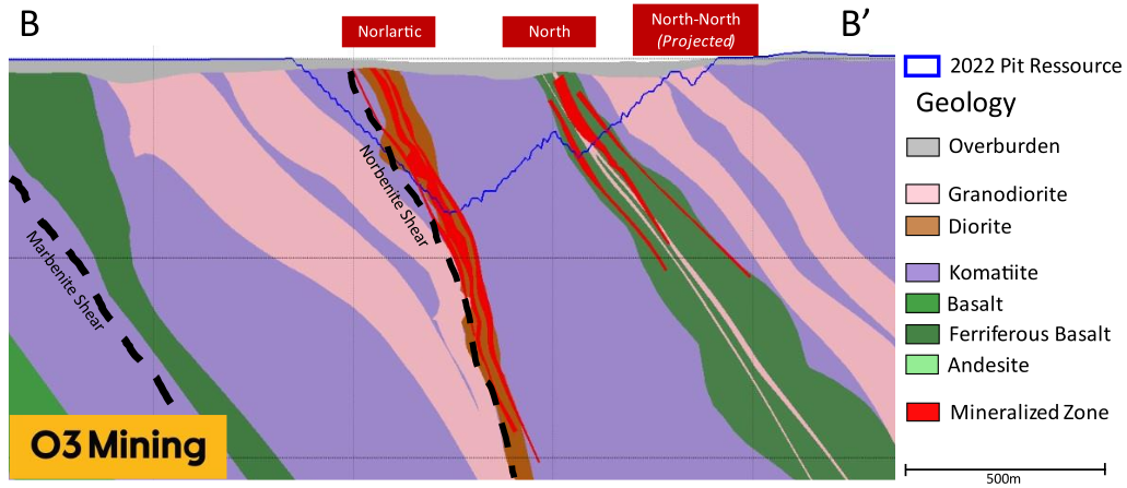
Located in the northern part of the west-north-west striking, north-dipping shear zones related to the Norbenite shear. The mineralization is related to a swarm of mafic to intermediate sills and dykes that intrude the shear zones (Lefrançois, 2005). The Norbenite shear is comprised of highly altered and deformed units of ultramafic volcanics and mafic to intermediate dykes. These units tend to be discontinuous due to the effects of superimposed shearing and drag folding and are thereafter cut by relatively undeform felsic dykes. The shear zone ranges from 45–90 m in width and is approximately conformable with encompassing hanging wall and footwall ultramafic units. The different lithological units present within the Norbenite deformation zone were well described by Stuart and Martin (1986). Some of the rock names have been modified in terms of new interpretations, but the descriptions are still accurate.
The mafic rocks, previously interpreted as volcanics and later as mafic dykes, make up 20–30% of the mineralized horizons and may occur anywhere within the zone. Thicknesses of individual units vary from a few centimetres to tens of metres. These rocks may be either relatively unaltered or intensely altered by albitization and carbonatization.
Relatively unaltered mafics are medium to dark green, non-magnetic, fine-grained, and massive to moderately foliated. Abundant fine-grained chlorite and carbonate are common. The altered mafic rocks are a distinct sub-unit representing up to 30% of the mafic unit. Those rocks are characterized by intense albitization, carbonatization, a quartz and quartz-carbonate stockwork is related to pyrite dissemination and generally contain economic gold mineralization. The matrix of the host rock within these altered zones is dark grey-green, fine grained, and probably recrystallized.
The komatiite makes up approximately 50% of the mineralized horizons, occurring in units varying from less than 1 metre to over 30 m in thickness. These rocks are typically blue-grey or green, have a soapy texture, and are very highly schistose and incompetent. They are composed of 50–70% fine-grained talc and chlorite, with 30–50% calcite and magnesite. The carbonates occur as greenish-white disjointed veins up to one centimetre wide that have a characteristic preferred orientation parallel to a well-developed, and commonly folded, schistosity.
The komatiites typically contain 1–2% medium to coarse-grained disseminated euhedral pyrite. Gold appears to be erratically distributed within this unit. The blue-grey komatiites are moderately to strongly magnetic and are the altered and deformed equivalents of the hanging wall and footwall komatiites. The green facies are non-magnetic, but their origin is probably similar to that of the blue-grey units, the green colour being due to the presence of abundant magnesian chlorite.
The intermediate dykes generally make up between 20% and 30% of the mineralized horizons and are an important host for mineralization in the Kierens and Norlartic areas. They range in thickness from a few centimetres to tens of metres, although rarely exceed 10 m, and are oriented parallel to the principal schistosity.
The intermediate dykes are typically medium to pale grey, rarely reddish grey (hematite staining), fine-grained to aphanitic, and have a massive to weakly foliated texture. They are usually strongly albitized and variably carbonatized, with primary textures often obliterated. In some cases, apparent recrystallization has taken place, which produces a medium- to coarse- grained, allotriomorphic, granular rock composed almost entirely of carbonate. The dykes also commonly contain 5–15% randomly oriented carbonate and quartz-carbonate veins.
The intermediate dykes usually contain between 2 and 5% fine-grained disseminated pyrite and can also contain significant associated gold values. In general, gold only occurs in trace amounts where the dykes are relatively homogenous, weakly or moderately altered, and contain fine disseminated pyrite, but the dykes host more important mineralization where they are strongly altered and are cut by numerous quartz-carbonate veins.
The mafic and intermediate dykes related associated with the Norlartic and Kierens mineralization are mainly calc-alkaline dykes that stands out of the tholeiitic nature of the Jacola Formation.
Mineralization:
The Norlartic deposit can be trace over a strike length of 800m down to a vertical depth of 800m. Gold was mined from two principal zones: the Main Zone and the Actinolite Zone, which are both now referred to as the Norlartic deposit. These zones are hosted by the Norbenite shear. The Main zone consists of a 5- to 15-metre-wide intermediate sill or dyke that
occurs within a large, sheared envelope of mafic rocks in the core of the Norbenite shear (Sauvé et al., 1993). Above the 500 level of the Norlartic mine, the main sill seems to change into a swarm of smaller dykes in ‘horse tail’ style. Gold is usually directly associated with the intrusion(s). The intermediate and mafic intrusions in the Norlartic zone have been strongly albitized and pyritized and have undergone intense brittle fracturing and quartz-carbonate-pyrite vein injection. Economic gold concentrations are found in quartz-calcite-pyrite vein stockworks that occur in closely spaced tabular intermediate intrusions. Hosting sheared komatiite also contain disseminated pyrite and are associated with gold, creating a wide auriferous envelope. On the east side of the historical shaft, the main target was the Actinolite Zone, where similar mineralization is hosted by a set of dioritic dykes in the hanging wall of the Main Zone. The higher percentage of actinolite in the ultramafic rocks hosting these mineralized dioritic dykes gave the zone’s name. The Norlartic mineralized zones were defined as three northwest-trending planar conformable with the Norbenite deformation corridor. A 0.3 g/t Au cut-off grade was used for the in-pit material while the cut-off for the under pit was raised to 2.0 g/t Au. A west-southwest planar structural component seems to intersect the zones in the old mine sector and while it doesn’t seem to displace the zone, the structure carries some continuous mineralisation, so a fourth zone was created to follow this structure.
Deposit types:
See description at Marban deposit.
Note:
For MRE effective date: 12 August 2020:
- The Mineral Resource estimate has been prepared by Sue Bird, P.Eng., an independent Qualified Person.
- The open pit Mineral Resource has been confined by a “reasonable prospects of eventual economic extraction” pit shell generated using the following assumptions: US$1,800/oz. Au at a currency exchange rate of 0.75 US$ per CDN$; 99.95% payable Au; CDN$4.30/oz Au offsite costs (refining, transport and insurance); a 3% NSR royalty; $16/t process and G&A costs; $2.60/t mining costs; grade dependent mill process recoveries; and pit slopes varying from 25 to 50 degree overall depending on geotechnical characteristics.
- The underground Mineral Resource reports all material within a continuous 3.5g/t Au gradeshell
- Metallurgical recovery is based on the formula: ln(Au)*0.0372+0.9017, maximum 96.7%
- The specific gravity of the deposit has been
- The table presents the combined resources for open-pit and underground extraction. Average gold grades were calculated as the ratio of contained gold (kg) to ore tonnage, rounded to two decimal places. Calculation goldmap.info
- Tonnage have been expressed in the metric system, and gold metal content has been expressed in troy ounces. Calculation of the amount of gold in metric kg - goldma.info
For MRE effective date: 27 February 2022:
- This shows the combined resources of the two properties: Kierens+Norlartic
- The lower cut-off grade for reporting the Mineral Resource is 0.30 g/t Au based on a recovery of 93.7%, Processing + G&A costs of C$18.2/tonne, Mining Cost of $2.40/tonne and a US$1900/oz Au price. The underground resource has been filtered manually to remove isolated blocks and has been reported using a 2.5 g/t lower cut-off at Kierens-Norlartic.
- The table presents the combined resources for open-pit and underground extraction. Average gold grades were calculated as the ratio of contained gold (kg) to ore tonnage, rounded to two decimal places. Calculation goldmap.info
- In general, a minimum thickness of 3 m was used when interpreting the mineralized bodies.
- The MRE is based on subblock models with a main block size of 5 m x 5 m x 5 m, with subblocks of 2.5 m x 2.5 m x 2.5 m.
- Tonnage have been expressed in the metric system, and gold metal content has been expressed in troy ounces. Calculation of the amount of gold in metric kg - goldma.info
- The tonnages have been rounded to the nearest 1,000 tonne and the metal content has been rounded to the nearest 1,000 ounce.
Mineral Resources (Aug. 12, 2020)
| Class | Ore (ktonnes) | Au grade (g/t) | Au (kg) | Au (oz * 1000) |
|---|---|---|---|---|
| Measured | 450.00 | 1.03 | 463.50 | 14.90 |
| Indicated | 7156.00 | 1.32 | 9463.60 | 304.93 |
| Inferred | 6418.00 | 1.45 | 9304.00 | 298.28 |
Mineral Resources (Feb. 27, 2022)
| Class | Ore (ktonnes) | Au grade (g/t) | Au (kg) | Au (oz * 1000) |
|---|---|---|---|---|
| Indicated | 15092.00 | 1.26 | 19047.82 | 614.00 |
| Inferred | 1250.00 | 1.70 | 2128.08 | 69.00 |
Source:
-
Marban Engineering NI 43-101 Technical Report and Mineral Resources Estimate
(13.04.2022, Val-d’Or)
Authors: Raponi Tommaso Roberto, Purchase James, Gariepy Louis, Vigneau Sébastien -
N.I. 43-101 TECHNICAL REPORT & PRELIMINARY ECONOMIC ASSESSMENT OF THE MARBAN PROJECT
(23.10.2020, Québec)
Authors: Raponi Tommaso Roberto, Elfen Scott, Petrina Mike, Bird Sue, Fontaine René