Marban
Phase: Exploration
Mine Type: Pit, Underground
Tags: albitization andesite archean basalt chlorite diorite dyke fuchsite granodiorite greenstone belt komatite monzonite porphyry pyrrhotite sericite sill stock stockwork tonalite
Canada, province of Quebec. The deposit is located in the western portion of the province, about midway between the towns of Val-d’Or and Malartic.
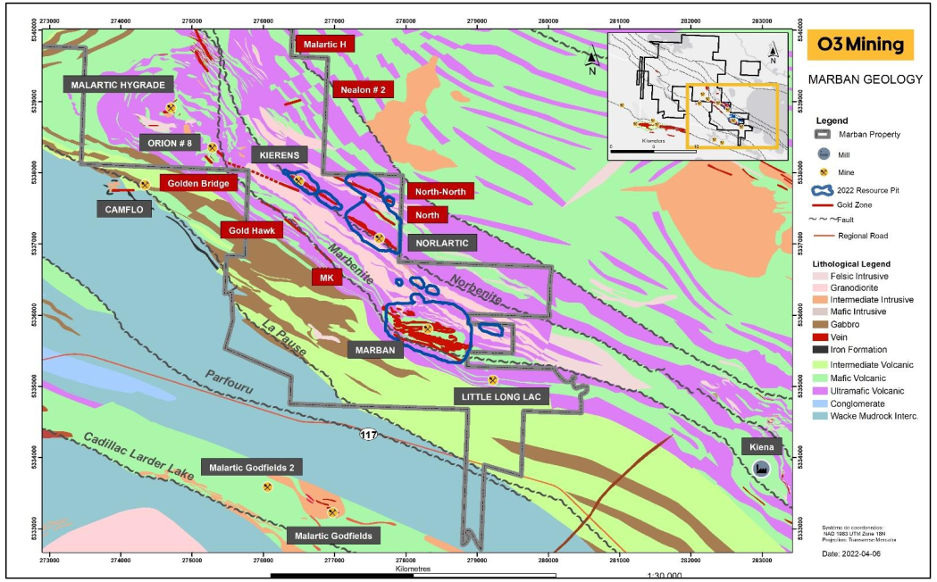
Located on the north side of Highway 117, approximately 15 km northwest of Val-d’Or, Quebec and immediately east of Canadian Malartic Partnership’s Camflo property. The project is accessible by the Gervais Road, a well-maintained all-weather gravel road running north from Highway 117. It provides access to the historic Norlartic, Kierens, and Marban mines. The Camflo road provides access to the western part of the project area. Winter access for snowmobiles and all-terrain vehicles is provided by trails and winter roads.
History:
Exploration conducted dates back to at least 1940 and includes geologic mapping, sampling, compilation of geological, structural, and geochemical data, geophysical prospecting, trenching, and extensive drilling from the surface and underground. At least 14 different companies explored and/or mined on parts of the property in the period of 1940 through 1994, including Norbenite Malartic Mines, Marbenor Malartic Mines, Little Long Lac Gold Mines Limited (Little Long Lac), Norlartic Mines Ltd., Marban Gold Mines (Marban Mines), East Malartic Mines, Malartic Gold Fields Ltd., First Canadian Gold Corp., Lloyd Harvey, Brominco Inc. (Brominco), Gold Hawk Resources, SOQUEM (Québec Department of Mines), Villebon Resources, Lac Minerals (Lac), Aur, and International Thunderwood Exploration.
- 1940. Norbenite Malartic Mines - (?). Prospecting, mapping and staking. Discovery of two gold-mineralized boulders.
- 1941–1956. Marbenor Malartic. Drilling of 96 holes, resulting in the discovery of two gold-bearing zones: Marban South and Marban North Zone.
- 1955. Marbenor Malartic. Marbenor Malartic Mines Ltd. re-organized to form the Consolidated Marbenor Mines Ltd.
- 1958. Marban Gold Mines Ltd. Marban Gold Mines Ltd. company created following an agreement between Consolidated Marbenor Mines Ltd. and Malartic Gold Fields Ltd. in order to put the Marban deposit into production
- 1959 - 1960. Marban Gold Mines Ltd. Underground development at the Marban mine, shaft sinking to -250 m, drifting on -61-, -107-, -15-2, -198-, and -244-m levels; production planned from the lower three levels. Malartic Gold Fields (affiliate of Lac Minerals) holds a 75% interest in Marban Gold Mines Ltd.
- 1961–1974. Marban Gold Mines Ltd. Production at the Marban mine over this 13-year period of 1,983,112 tonnes grading 5.2 g/t Au and 6.8 g/t Ag. Milling was carried out at the Malartic Gold Fields facilities.
- 1963. Marban Gold Mines Ltd. Magnetic survey, geological survey, and a few drillholes.
- 1984–1985. Lac Minerals Ltd. Work completed includes line cutting (122-m spacing), compilation maps, geology and drill-hole geology at 1:200 and 400 scales, updating of vertical sections, longitudinal projections, and level plans. Detailed geological and structural survey at 1”=50’ (survey extended into the summers of 1985 & 1986). Geophysical surveys include magnetics/gradient, VLF, IP, and HEM supplementary line cutting at 61-m spacing. Supplementary magnetic surveys (total field & gradient). Lithogeochemical survey, including major elements and gold.
- 1985. Lac Minerals Ltd. Geological and structural mapping.
- 1986. Lac Minerals Ltd. Geological and structural synthesis by Bourget and Bugnon. Gold distribution study, which suggested that the gold is structurally controlled. Diamond drill program of 1,862 m in 12 holes completed. Regional compilation map at 1”=1,000’. Definition magnetic contouring at 100 gamma intervals. DDH lithogeochemical sampling for major elements and gold. Major element lithogeochemical interpretation report. Au in ppb distribution summarized in interpretation report. Partial IP survey over Kewagama–Malartic contact. Construction of a 3-D model of the Marban mine.
- 1987–1988. Lac Minerals Ltd. Phase I Drill Program: 12,268 ft in 18 holes. Phase II Drill Program: drilling below - 244-m level to test depth extensions with 18 holes (3,658 m). Updating of all mine sections with new holes. Revision of regional compilation map, 1”=1,000’. Overburden stripping in eastern part of property. Magnetic compilation of Marban area. Geologic compilation of Marban area (1”=400’). Entry of all old holes into database. Aur bought back an outstanding NSR at Marban from Canhorn Mining Corp.
- 1989–1991. Lac Minerals Ltd. Exchange of geological information between Aur and Lac. Negotiation between Lac and Aur for the NSR. Lithogeochemical sampling of Marban tonalite. Resampling of holes MBS-88-25 and MBS-88-26. Two memos (04/05/1990) to D.E. Malloy; ‘Possible Camflo-type Mineralization within the Marban Property’ and ‘Marban Vein Type Lode Gold Mineralization.’ Major & trace elements geochemistry as assessment work for 1990–1991.
- 1992. Aur Resources. Aur optioned the property from Lac Minerals for its bulk-tonnage potential. The Marban “tonalite” was identified as a high-priority target (similar setting to Camflo). The second target identified was a pronounced Z-shaped magnetic embayment or bend.
- 1994. Aur Resources. Five overburden holes drilled in a grid-like pattern for follow-up of hole 22 (5 gold counts). Diamond drilling program totaling 4,224 m (10 holes) consisting of 6 holes to test the potential of the Marban Tonalite, 2 holes (501-09 and 501-11) to continue a section across the Héva Formation, and 2 holes (501-13 and 501-14) to test the area around the magnetic inflection of the interpreted Héva-Kewagama contact. All the holes that intersected the tonalite had only minor sulfide mineralization, and although the alteration was fairly strong in these holes, it was most intense in hole 501-08, which returned 675 ppb Au over 0.9 m, the best gold assay of the program. The background gold content of the Marban Tonalite in all holes was low, with almost all samples returning less than 50 ppb Au.
- 2006. NioGold. High resolution 50-m spacing mag survey by Prospectair Inc.
- 2007. NioGold. Abitibi Geophysics of Val-d’Or conducted an orientation IP survey designed to detect near-surface gold-bearing disseminated pyrite mineralization intersected in holes MB-06-001 and MB-06-002 in the Marban mine area. One 1,250-m north-south line was tested that passed over the collars of the holes, but the survey did not detect any
chargeability response. This lack of response may have been due to thick overburden, and/or the pyrite may be too coarse. - 2006–2007. NioGold. Petrographic study of the gold mineralization in the North-North and Marban (hole MB-06-001). The study of the Marban mineralization indicated that gold grains are intimately linked to coarse pyrite, either as fracture filings in the crystals or as inclusions. Fine-grained pyrite contains far fewer gold grains than coarse-grained pyrite, which is more strongly associated to veins than fine-grained pyrite.
- 2007–2008. NioGold. Ninety-four holes and two wedges for a total of over 33,000 m. Little exploration work was conducted in 2009 on the Marban Blocks. Fence of four core holes (1,736 m) 1 km east of the Marban shaft, about 450 m east of any previous holes.
- 2008. NioGold. Technologies Earthmetrix conducted a structural study of the Marban Block property using LANDSAT imagery.
- 2010. NioGold. Three (3) holes (905.6 m) 900 m west of the shaft at the Marban deposit, with another two holes (330.3 m) drilled to test the Marban Northeast zone.
- 2010–2011. NioGold Aurizon. Phase I Program that included 146 new holes and extensions of eight holes previously drilled at and just north of the Marban deposit.
- 2011–2012. NioGold Aurizon. Phase II Program that included 90 holes and extensions of another 9 previous holes.
- 2014–2015. NioGold. Two hundred forty-six (246) supplementary holes representing 72,489 m were drilled at Marban to complete the drilling pattern to about 25 m by 50 m
- 2015–2016. NioGold. Twelve (12) PQ-sized holes totalling 1,692 m, drilled for comminution tests on Norlartic, Kierens, and Marban deposits.
- 2016–2017. Osisko Mining. Twenty-six (26) holes testing down dip extension of the Marban, Norlartic and Kierens deposits totaling 15,171 m.
Mining at the deposit was carried out by Marban Gold Mines from 1961 to 1974. A total of 1.983 million tonnes of ore with an average grade of 5.3 g/t were mined, yielding approximately 330,000 ounces of gold.
Regional geology: Abitibi greenstone belt
Abitibi greenstone belt of the Superior province of the Canadian Shield. The area consists mostly of felsic to mafic volcanic rocks of Archean age together with related dioritic sills which are concordant to the regional rock formations. These volcanic and intrusive rocks have generally been metamorphosed to the greenschist facies.
The Superior Province is the largest exposed Archean craton in the world and hosts several world class gold deposits. It has yielded nearly 300 million ounces of gold from hundreds of deposits since the beginning of the twentieth century. One prominent characteristic of all significant gold deposits in the Superior Province is their occurrence within or immediately adjacent to greenstone belts. Another characteristic is their occurrence within major tectonic zones which comprise a series of shear zones (Colvine et al., 1988). The Superior Province is divided into four major subprovince types (Card and Ciesielski, 1986): volcano-plutonic, plutonic, metasedimentary, and high metamorphic grade gneiss. The boundaries of these subprovinces are either major dextral, transcurrent, east-striking faults, or zones of structural and metamorphic transition.
The greenstone belts which host the gold deposits occur as east-north-easterly trending ribbon domains in the volcano-plutonic terrains. They typically consist of mafic to ultramafic and felsic metavolcanic …
Local geology:
The Marban is located in the southern portion of the SVZ, where the Parfouru fault and the associated sedimentary rocks of the Kawagama Group separate the Blake River segment to the west from Malartic segment to the east (Daigneault et al., 2002). The western portion of the property contains the eastern end of the Blake River Group, composed of basalt and andesitic basalt of the Hébécourt Formation (2703–2702 Ma) (McNicoll et al., 2014) which consist of a north-dipping panel with faulted contacts bordered with the sedimentary units of the Kewagama to the north and Cadillac to the south (De Souza et al., 2020). To the east, the Malartic segment is subdivided into the Malartic Group and the Louvicourt Group. The Malartic Group consists of plume-derived komatiitic-tholeiitic marine-plain volcanic assemblages, divided from north to south, into the La Motte-Vassan, Dubuisson, and Jacola formations. In contrast, the overlying Louvicourt Group represents an arc-type complex. The Louvicourt Group is subdivided into the Val-d’Or Formation, a transitional to calc-alkaline volcanic complex, and the Héva Formation, characterized by geochemically distinct iron tholeiites.
The Canadian Malartic Mine, owned by the Agnico Eagle-Yamana Gold Partnership which includes the historical mine production of the East Malartic, Barnat-Sladen, Canadian Malartic, and Malartic Goldfields gold deposits, occur within a 900 m-wide band of highly sheared and faulted rocks named the Malartic Tectonic Zone (MTZ), part of the 300-km-long Cadillac-Larder Lake Tectonic Zone. The mine sector as been estimated to a global gold content of up to 33.0 million ounces (Moz) (including past production until the end of 2020, Reserves and Measured, Indicated and Inferred resource estimation (Lehouiller et al, 2020). Two other northwest-striking fault systems are recognized to the north of the MTZ, namely the Norbenite and Marbenite shear zones. These two shear zones are important controls on the localization of gold within the Malartic district, as numerous deposits occur along these structural zones, including Gold Hawk, Kierens , Norlartic, Marban, Kiena, Shawkey, Wisik, and Goldex. Stratigraphic units in the area of the Malartic district generally strike at 300° azimuth, and their contacts are usually sheared and faulted. Two other faults have been documented bordering the Kewagama group to the northeast and southwest, respectively, the La Pause Fault and Parfouru Fault.
The units are mainly oriented northwest-southeast and dip to the northeast, although they are oriented more west-northwest–east-southeast in the southeastern portion of the property with a dip to the north. The rocks become younger to the southwest, forming an overturned sequence on the south limb of the La Motte-Vassan Anticline. The northeast half of the property is underlain by komatiites and basalts belonging to the Jacola Formation of the Malartic Group. They appear to be in conformable contact with the mafic pyroclastics, volcanics and volcanoclastic rocks belonging to the Héva Formation that belong to the Louvicourt Group. These in turn are in contact with sedimentary rocks of the Kewagama Group. Dykes and sills of various compositions intrude all these units.
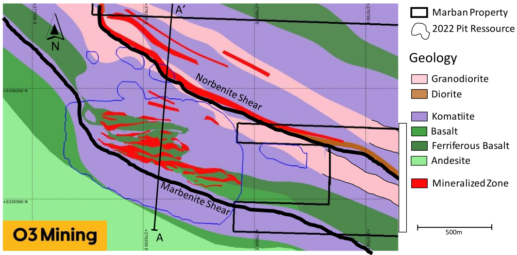
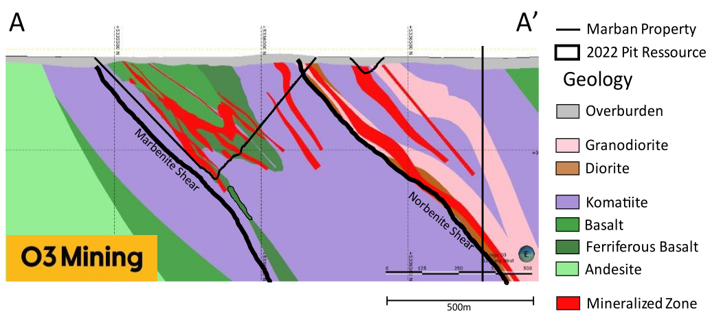
The volcanic rocks of the Jacola Formation contain three major NW-SE oriented deformation corridors, from northeast to southwest, the North, Norbenite and Marbenite shears. The North Shear affects the basalts and parts of the komatiites of the North Zone. The full extent of this shear zone is unknown. The Norbenite Shear affects the komatiites and dioritic dykes that form the Kierens and Norlartic deposits. The Norbenite is an important northwest-trending deformation zone with a moderate to steep dip to the northeast and up to 150 m width on the property. The Marbenite Shear hosts the Marban deposit and the Gold Hawk Horizon. It is oriented east-west to west-northwest–east-southwest with a moderate to steep dip to the north and northeast and up to 450 m width. All the deformation corridors are going through the property from east to west. The rocks are also affected by late-east-west structures including schistosity and northeast-southwest-trending faults.
Two major granodiorites and one tonalite sills intrude the Jacola Formation subparallel to stratigraphy. The northernmost intrusion, known as the North-North Granodiorite, hosts the North-North Zone. The second intrusion named the Central Granodiorite is located between the Norbenite and the Marbenite shears. Several decimetric to metric mafic to intermediate dykes intrude all the previous units. To the west of the Marban Engineering sector, the Camflo mine is partly hosted in a porphyritic monzonite, the Camflo stock (U-Pb on zircon 2685 +10/-8 Ma, Zweng et al., 1993; U-Pb on titanite 2680 ±4 Ma; Jemielita et al., 1990), that is injected within the northern part of the Kewagama, at the contact with the Jacola.
Deposit geology:
The Marban deposit is located at the Marbenite shear and extend in the hanging wall rocks for several hundreds metres. It sits immediately to the east of a curvature in the Marbenite which is trending more east-west in this particular area. The southernmost part of the mineralisation is hosted by a strongly sheared komatiite unit within the Jacola Formation. Going
north, the Mine Sequence corresponds to basaltic volcanics hosting most of the gold mineralization of the deposit. The mafic unit in the Marban deposit presents a significant thickening, compare to the correlated basalt horizon east and west, due to a multi-phased folding that shows a doubly plunging fold axis interference pattern which implies an early fold phase overprinted by subsequent east-west folding. The basaltic unit can be geochemically divided into two different basalts. A Mg-rich basalt to the south that overlay a ferriferous basalt to the northern part of the Mine Sequence.
The Marban deposit is also characterised by minor cross-cutting shear that link early fold hinges together. Those shears are plunging 40–70 degrees to the north and often host gold zones. North of the basaltic units, the komatiite is injected by multiple felsic dykes, namely the Marban Dyke area. Those dykes a locally strongly altered and sheared ang contain gold mineralisation.
Mineralization:
The Marban mine is located in the southeast portion of the property and is situated within the northern part of the Marbenite shear zone. The mineralization can be followed over a strike length of 1.1km and down to a vertical depth of 650m.
Gold mineralization is hosted primarily within the Mine Sequence basalts and mostly within the ferriferous basalt or at its folded contact with the magnesian basalt. Within the basalt, the mineralization consists of quartz and quartz–carbonate–chlorite veins and veinlets with disseminated pyrite and pyrrhotite mostly within the chloritized and albitized wall rock. Veins and veinlets vary in thickness from one centimetre to few metres, but they form stockworks that can be up to 70 m thick. At the core scale, the tight folding of veinlets can be observed. Thicker quartz veins often have angular chloritized fragments of wall rock. This texture is characteristic of gold bearing veins of the Marban project and is found at Marban, Orion, Norlartic, and Kierens deposits. The folded nature of the veinlets is reflected into the shape of many historical mine stopes that drawn close fold pattern with an east-west subhorizontal plunge. This folded nature is also reflected at a broader scale where the main stockwork envelope form a ‘Z’ shaped fold in cross-section with an east-west subhorizontal plunge. The mineralization is thicker in the fold hinges but still present along the limbs.
Mineralization is also hosted in local east-west shear zones that pass through the basaltic units. Those shear zones dips at 45–70° toward the north. The aspect of the mineralization is similar than within the stockwork envelope but some strongly sheared slivers of komatiite and komatiitic basalt are present in those shears.
The sulphide content related to gold consist of pyrite and pyrrhotite, with free gold occurring locally. Gold bearing pyrites are anhedral to euhedral and fine- to medium-grained and can also occur as subhedral to anhedral clusters mobilized by the deformation (Beauchamp, 2010). Pyrite also appears as coarse-grained sub to euhedral dissemination in the host rocks. The pyrrhotite is mainly visible as fine-grained anhedral clusters often elongated along shear planes. Gold may also be disseminated within the mafic volcanic rocks are within quartz veins. Although free gold is observed, the gold generally occurs as inclusions or fillings in cracks in pyrite (Renou, 2007).
North of Mine Sequence basalt, gold mineralization is hosted in the granodiorite and ultramafic flows, in an area called the Marban Dyke. The mineralized granorioritic dykes are strongly sheared al altered in sericite, fuchsite and at a lesser extent, chlorite. Centimetric clusters of pyrite are disseminated within the altered dyke.
At Marban and along the Marbenite, a very high-grade component is observed as in hole MB-11-170, were two centimetric veins of gold were intercepted (3% gold over 0.5m; press release NioGold 25 May 2011). Those spectacular grades are probably related to late remobilization along discrete structures. Isolated high-grade intercepts outside known mineralized were not model for the current MRE.
Out of the very high-grade component, the gold grade distribution inside the mineralized zones is predictable with rakes along the sub-horizontal axial plunges.
Deposit types:
The Marban property hosts at least two types of gold mineralization. A first related to the major shears of the property, namely Marbenite, Norbenite, and North shears. Those shears are also related to the Kiena and Goldex deposits. The Kiena deposit lies within the same rocks of the Jacola formation than the mineralization of the Marban project and its mineralization shows similar characteristics. Along those shears, within the Marban property, the mineralization consists of quartz and quartz–carbonate–chlorite veins and veinlets within mafic and intermediate rocks. The thickest quartz veins of this type contain angular fragments of the host rocks. Alteration of the host rock consist of albitization, carbonatization and chloritization, tourmaline is absent. This style of mineralization is common, regardless of the host rocks, to Marban, Norlartic, Kierens, North, and Orion deposits. Sulphide content is generally below 2% and consists in disseminated pyrite in the wall rock. At Marban and Orion deposit the veins and veinlets are mainly hosted within an iron-rich basalt and are either transposed along the main schistosity or folded. At a larger scale, those two deposits concentrated along subhorizontal early-fold hinges, a folding event that pre-date the main deformation event, D2, in the southern Abitibi region, which is related to the penetrative subvertical schistosity and associated subvertical folds. At Norlartic and Kierens, the veins and veinlets are hosted in intermediate dykes and are less deformed possibility due to a more competent host rock. Couture et al. (1994) and Bertrand-Blanchette (2016) have documented the mineralization is cut by tonalitic intrusions respectively dated at 2692 ± 2 Ma for Norlartic and 2680 ± 1 Ma for Orion. The implication of those relative and absolute timing is that at least part of the mineralization is older than the main deformation event recorded in the southern Abitibi region. Although the mineralization shares multiple characteristics of orogenic gold deposits, namely the association with major shear, the carbonite and albite alteration and the lack of significant base metal or silver content, they are much older than the orogenic gold deposits of the Val-d’Or mining district (Sigma-Lamaque and others). They then can be classified as pre-main deformation event Archean orogenic gold deposits (Couture et al., 1994; De Souza et al, 2020).
The tonalitic and granodioritic intrusions that cut the early mineralization are also locally mineralized. The best example is the North-North zones hosted within a tonalitic intrusion. This zone consists of quartz–carbonate–tourmaline veins surrounded by albite alteration halos. They are very similar to the vein systems found at Sigma-Lamaque and Goldex mines. The veins are spatially associated with discrete shear but the veins itself are relatively undeformed. The same kind of gold -bearing veins are also found within the felsic intrusion south of the Norlartic deposit dated at 2692 ± 2 Ma (Couture et al., 1994). This mineralization event is classified as Sigma-Lamaque, as Archean orogenic gold deposit.
The Marban Dyke mineralization, located in the northern part of the Marban deposit is different from the two previous styles of mineralization. It consists of a dissemination of pyrite clusters in strongly sericitized and sheared felsic dykes. The pyrite clusters that correlate with the gold content are relatively undeformed compared to their host rock. The mineralization could be contemporaneous of the quartz–carbonate–tourmaline veins but further studies need to be made to be able to classify this mineralization with a good level of confidence.
Note:
For MRE effective date: 12 August 2020:
- The Mineral Resource estimate has been prepared by Sue Bird, P.Eng., an independent Qualified Person.
- The open pit Mineral Resource has been confined by a “reasonable prospects of eventual economic extraction” pit shell generated using the following assumptions: US$1,800/oz. Au at a currency exchange rate of 0.75 US$ per CDN$; 99.95% payable Au; CDN$4.30/oz Au offsite costs (refining, transport and insurance); a 3% NSR royalty; $16/t process and G&A costs; $2.60/t mining costs; grade dependent mill process recoveries; and pit slopes varying from 25 to 50 degree overall depending on geotechnical characteristics.
- The underground Mineral Resource reports all material within a continuous 3.5g/t Au gradeshell
- Metallurgical recovery is based on the formula: ln(Au)*0.0372+0.9017, maximum 96.7%
- The specific gravity of the deposit has been
- The table presents the combined resources for open-pit and underground extraction. Average gold grades were calculated as the ratio of contained gold (kg) to ore tonnage, rounded to two decimal places. Calculation goldmap.info
- Tonnage have been expressed in the metric system, and gold metal content has been expressed in troy ounces. Calculation of the amount of gold in metric kg - goldma.info
For MRE effective date: 27 February 2022:
- The lower cut-off grade for reporting the Mineral Resource is 0.30 g/t Au based on a recovery of 93.7%, Processing + G&A costs of C$18.2/tonne, Mining Cost of $2.40/tonne and a US$1900/oz Au price. The underground resource has been filtered manually to remove isolated blocks and has been reported using a 3.0 g/t Au lower cut-off for Marban.
- The table presents the combined resources for open-pit and underground extraction. Average gold grades were calculated as the ratio of contained gold (kg) to ore tonnage, rounded to two decimal places. Calculation goldmap.info
- In general, a minimum thickness of 3 m was used when interpreting the mineralized bodies.
- The MRE is based on subblock models with a main block size of 5 m x 5 m x 5 m, with subblocks of 2.5 m x 2.5 m x 2.5 m.
- Tonnage have been expressed in the metric system, and gold metal content has been expressed in troy ounces. Calculation of the amount of gold in metric kg - goldma.info
- The tonnages have been rounded to the nearest 1,000 tonne and the metal content has been rounded to the nearest 1,000 ounce.
For MRE effective date: 17 August 2022:
- The Qualified Person for the estimate is Mr. Carl Michaud, Eng. M.B.A., Vice President of Mining Engineering for GMS. Effective date of the estimate is
August 17, 2022. - Mineral reserves are estimated for a long-term gold price of US$ 1,600/oz.
- Mineral reserve cut-off grade is 0.3 g/t Au for all materials.
- A dilution skin width of 1 m was considered resulting in an average mining dilution of 5.4%. 6. The average strip ratio is 5.07:1. 7. Numbers may not add
due to rounding.
Mineral Resources (Aug. 12, 2020)
| Class | Ore (ktonnes) | Au grade (g/t) | Au (kg) | Au (oz * 1000) |
|---|---|---|---|---|
| Measured | 65.00 | 1.32 | 85.80 | 2.76 |
| Indicated | 46480.00 | 1.06 | 49357.20 | 1591.65 |
| Inferred | 6769.00 | 1.43 | 9700.80 | 312.54 |
Mineral Resources (Feb. 27, 2022)
| Class | Ore (ktonnes) | Au grade (g/t) | Au (kg) | Au (oz * 1000) |
|---|---|---|---|---|
| Indicated | 52599.00 | 1.04 | 54734.25 | 1759.00 |
| Inferred | 1898.00 | 2.54 | 4816.66 | 155.00 |
Reserves (Aug. 17, 2022)
| Class | Ore (ktonnes) | Au grade (g/t) | Au (kg) | Au (oz * 1000) |
|---|---|---|---|---|
| Probable | 56437.00 | 0.91 | 51357.67 | 1647.00 |
Source:
-
Marban Engineering Project NI 43-101 Technical Report & Prefeasibility Study
(07.10.2022, Val-d’Or)
Authors: Purchase James, Barrette Renee, Michaud Carl, Hooshiar Ali, Hasanloo Davood, Hamel Andréanne -
Marban Engineering NI 43-101 Technical Report and Mineral Resources Estimate
(13.04.2022, Val-d’Or)
Authors: Raponi Tommaso Roberto, Purchase James, Gariepy Louis, Vigneau Sébastien -
N.I. 43-101 TECHNICAL REPORT & PRELIMINARY ECONOMIC ASSESSMENT OF THE MARBAN PROJECT
(23.10.2020, Québec)
Authors: Raponi Tommaso Roberto, Elfen Scott, Petrina Mike, Bird Sue, Fontaine René