Kierens
Phase: Exploration
Mine Type: Pit, Underground
Tags: albitization andesite archean basalt calcite carbonatization diorite dyke granodiorite greenstone belt komatite stockwork
Canada, province of Quebec. The deposit is located in the western portion of the province, about midway between the towns of Val-d’Or and Malartic.
Located on the north side of Highway 117, approximately 15 km northwest of Val-d’Or, Quebec and immediately east of Canadian Malartic Partnership’s Camflo property. The project is accessible by the Gervais Road, a well-maintained all-weather gravel road running north from Highway 117. It provides access to the historic Norlartic, Kierens, and Marban mines. The Camflo road provides access to the western part of the project area. Winter access for snowmobiles and all-terrain vehicles is provided by trails and winter roads.
History:
Estimated historical gold production (include Gold Hawk): Norlartic Mines - 1959-1966; Aur Resources - 1988-1992. Total: 251 kt ore, Au grade - 6.3 g/t, Au ounces*1000 - 52.
The Kierens zone on the First Canadian historical property was discovered one kilometre west of the Norlartic shaft by surface drilling (18 drillholes; 5,054 m) completed in 1963–1964. The Kierens zone was reached by drifting 1,190 m on the 229-m level from the Norlartic mine in 1964–65, and underground development and drilling followed (37 drillholes; 2,281 m).
Records indicate that Aur completed a total of 143 surface drillholes on the First Canadian historical property from 1985–1989. The up-dip extensions of the Kierens zone (three drillholes; 611 m) were tested in 1985–1986. An intersection of 12.00 g/t Au over 4.6 m prompted a second program (18 drillholes for 5,063 m) that tested the Kierens zone over a strike
length of 425 m and to a depth of 275 m. High-grade gold intersections were obtained west of the old mine workings. Surface drilling and underground development and drilling followed in 1986 and 1987. This work included the sinking of a 380-m, vertical, two-compartment shaft, 20 surface holes (4,580 m), and 122 underground holes (11,414 m), mainly on the
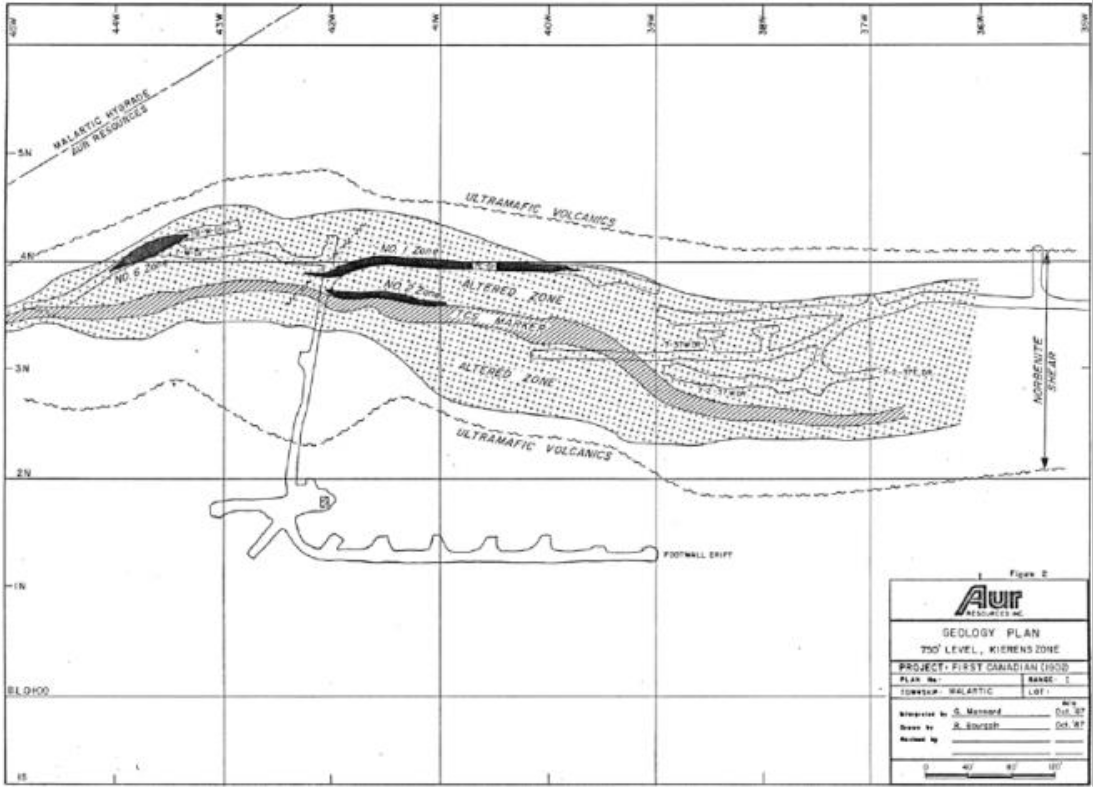
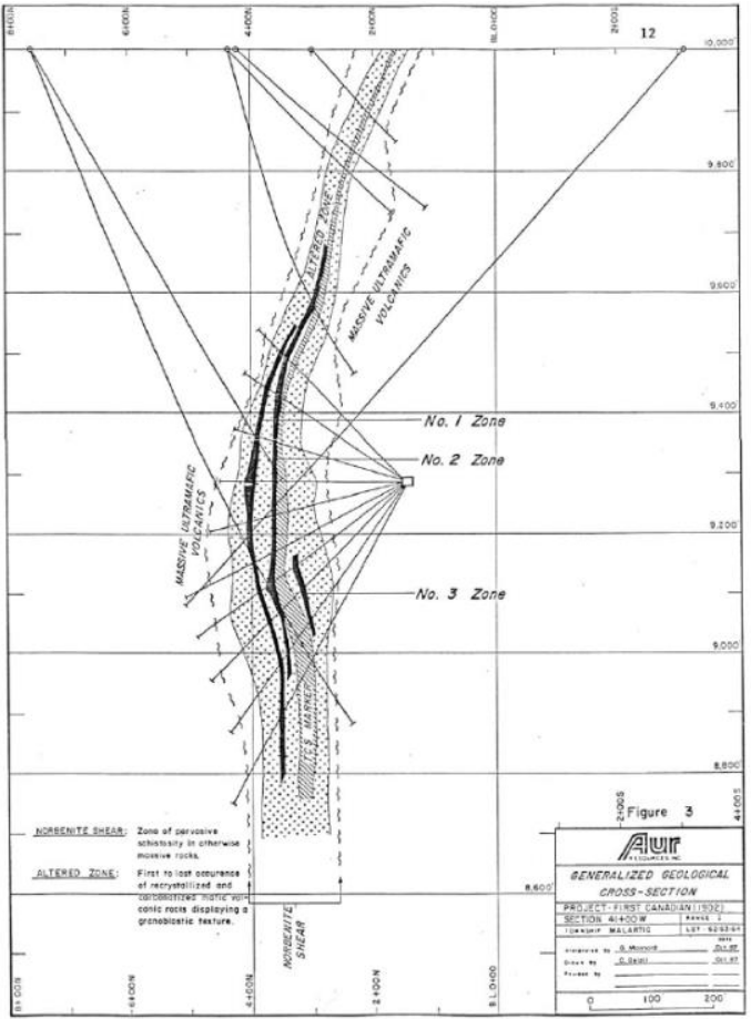
223-m level. Four individual zones (No. 1, 2, 3, and 6) of quartz–pyrite–gold stockwork that plunge moderately to steeply east were delineated, three of them displaying good continuity (Zones No. 1, 2, and 6).
After 1988, the project was administered by the Kierens Mining Division.
Aur produced approximately 50,000 ounces of gold from the Kierens mine from 1988–1992.
Regional geology: Abitibi greenstone belt
Abitibi greenstone belt of the Superior province of the Canadian Shield. The area consists mostly of felsic to mafic volcanic rocks of Archean age together with related dioritic sills which are concordant to the regional rock formations. These volcanic and intrusive rocks have generally been metamorphosed to the greenschist facies.
The Superior Province is the largest exposed Archean craton in the world and hosts several world class gold deposits. It has yielded nearly 300 million ounces of gold from hundreds of deposits since the beginning of the twentieth century. One prominent characteristic of all significant gold deposits in the Superior Province is their occurrence within or immediately adjacent to greenstone belts. Another characteristic is their occurrence within major tectonic zones which comprise a series of shear zones (Colvine et al., 1988). The Superior Province is divided into four major subprovince types (Card and Ciesielski, 1986): volcano-plutonic, plutonic, metasedimentary, and high metamorphic grade gneiss. The boundaries of these subprovinces are either major dextral, transcurrent, east-striking faults, or zones of structural and metamorphic transition.
The greenstone belts which host the gold deposits occur as east-north-easterly trending ribbon domains in the volcano-plutonic terrains. They typically consist of mafic to ultramafic and felsic metavolcanic …
Local geology:
See description at Marban deposit.
Deposit geology:
See description at Norlartic deposit.
Mineralization:
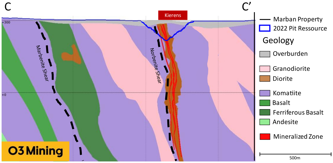
The Kierens deposit can be trace over a strike length of 900m down to a vertical depth of 700m. Stuart and Martin (1986) have documented that gold mineralization at Kierens is primarily associated with disseminated and fracture-controlled pyrite and occurs in a strongly albitized and carbonatized zone that ranges in thickness from 3–30 m. The alteration zone generally occupies the central portion of the Norbenite shear and is broadly conformable with it. The alteration zone affects sheared ultramafic rocks as well as more massive intermediate to mafic planar intrusions that appear as boudins and dislocated lenses that are difficult to correlate vertically. The main control on gold mineralization within the shear zone appears to be a westerly plunging drag fold. Gold is concentrated in the hinge zone of this fold structure, which may have acted as a trap for gold-bearing hydrothermal fluids (Stuart and Martin, 1986).
At the Kierens deposit, three sub-planar zones parallel to the Norbenite shear were modelized. Those zones are lightly offset by an east-northeast structure on the eastern part of the zone. An east-northeast structure also characterizes the western part and seems to mostly terminate the division between three different zone for the deposit. As for the Norlartic deposit, the Kierens mineralized shell were designed following a 0.3 g/t Au cut-off grade for the in-pit material while the cut-off for the under pit was raised to 2.0 g/t Au.
Deposit types:
See description at Marban deposit.
Note:
See MRE at Norlartic deposit
Source:
-
Marban Engineering NI 43-101 Technical Report and Mineral Resources Estimate
(13.04.2022, Val-d’Or)
Authors: Raponi Tommaso Roberto, Purchase James, Gariepy Louis, Vigneau Sébastien -
N.I. 43-101 TECHNICAL REPORT & PRELIMINARY ECONOMIC ASSESSMENT OF THE MARBAN PROJECT
(23.10.2020, Québec)
Authors: Raponi Tommaso Roberto, Elfen Scott, Petrina Mike, Bird Sue, Fontaine René