Sierra Madre Occidental province
Tags: andesite dacite eocene lava miocene oligocene rhyolite
Description:
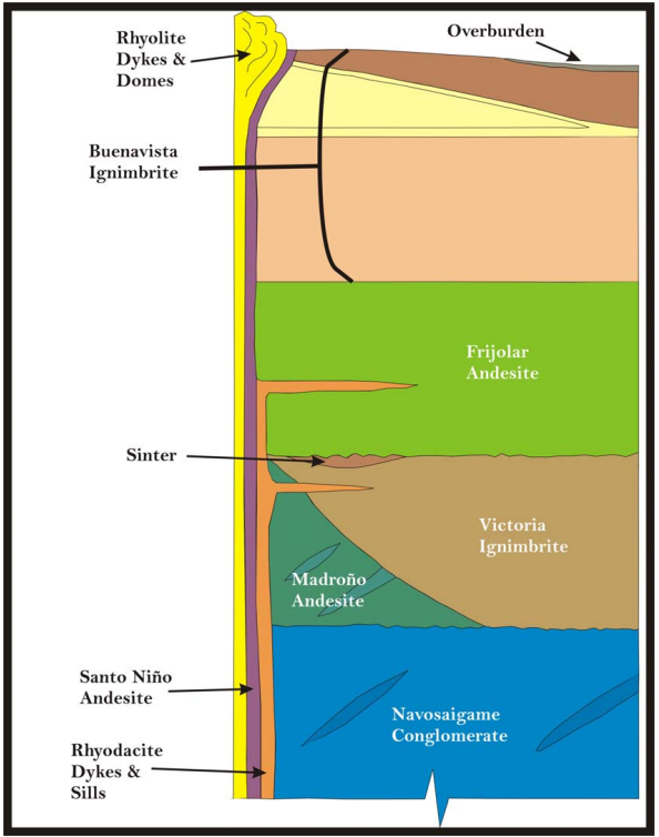
The Sierra Madre Occidental (SMO) province, a regionally extensive Eocene to Miocene volcanic field, which extends southeast from the United States – Mexico border to central Mexico. The total thickness of the volcanic sequence is approximately 2 km, and it rests upon Mesozoic clastic and calcareous sedimentary rock. The volcanic field is comprised of two distinct volcanic sequences, an older andesitic and dacitic series, and a younger pyroclastic-dominated rhyolitic series. The traditional nomenclature refers to these as the Serie Volcanica Inferior (Lower Series) and Serie Volcanica Superior (Upper Series). The Lower Series is approximately 1 km thick and is dominated by Paleocene and Eocene andesitic lavas and pyroclastic deposits, with interbedded volcaniclastic strata. Silicic volcanic units are present but are a minor component. The volcanic strata of the Lower Series are cut by calc-alkaline intrusives. The Upper Series unconformably overlies the Lower Series with erosional disconformity, and comprises a 1-km-thick sequence dominated by Oligocene and early Miocene dacitic and rhyolitic pyroclastic strata and volcaniclastic strata. Most significant metal occurrences in the SMO are hosted by rocks of the Lower Series or the underlying Mesozoic strata.
Regional stratigraphy :
On a regional scale, the SMO is a relatively undeformed high plateau (Henry and Aranda-Gomez, 1992). Overall, there is a northwest-trending structural fabric best evidenced by the alignment of the numerous mining districts found in the SMO. According to Bockoven (1980), the most important structures in the Ocampo-Yécora area are related to the development of calderas and Basin and Range type of normal faulting, which the Ocampo caldera, of 40-50 km in diameter, is the most obvious morphostructural element. From the satellite work it appears that Ocampo lies near the centre of a major caldera and is surrounded by at least two others. Henry and Aranda-Gomez suggest that the SMO is relatively undeformed due to the presence of a large batholith that underlies it. This inferred batholith is believed to be source of the very large volume of volcanic rocks. Structures in the basement are more difficult to find due to the lack of outcrops of old rocks, although Mullan and al. (1978) have interpreted a polyphased deformation associated with the Nevada and Sonoma Orogenies in the metamorphic rocks of the La Nopalera region. Zaragoza (1997) interpreted the structural succession as follows, from oldest to youngest event:
- NNW fault system that provides a feeding trough for caldera generator magmas
- Holding of the Navasaigame conglomerate, with northwest tendency, related to the Laramide Orogeny
- Caldera-related structures
- Younger northwest fault system
- Basin and Range type of extensional faults which generate the NW30° (trend) of the Sierra, some of them intersect and reactivate structures associated with caldera, and generate grabens like the one east of Yécora and in the Yepachic-Pilares region
Deposits
-
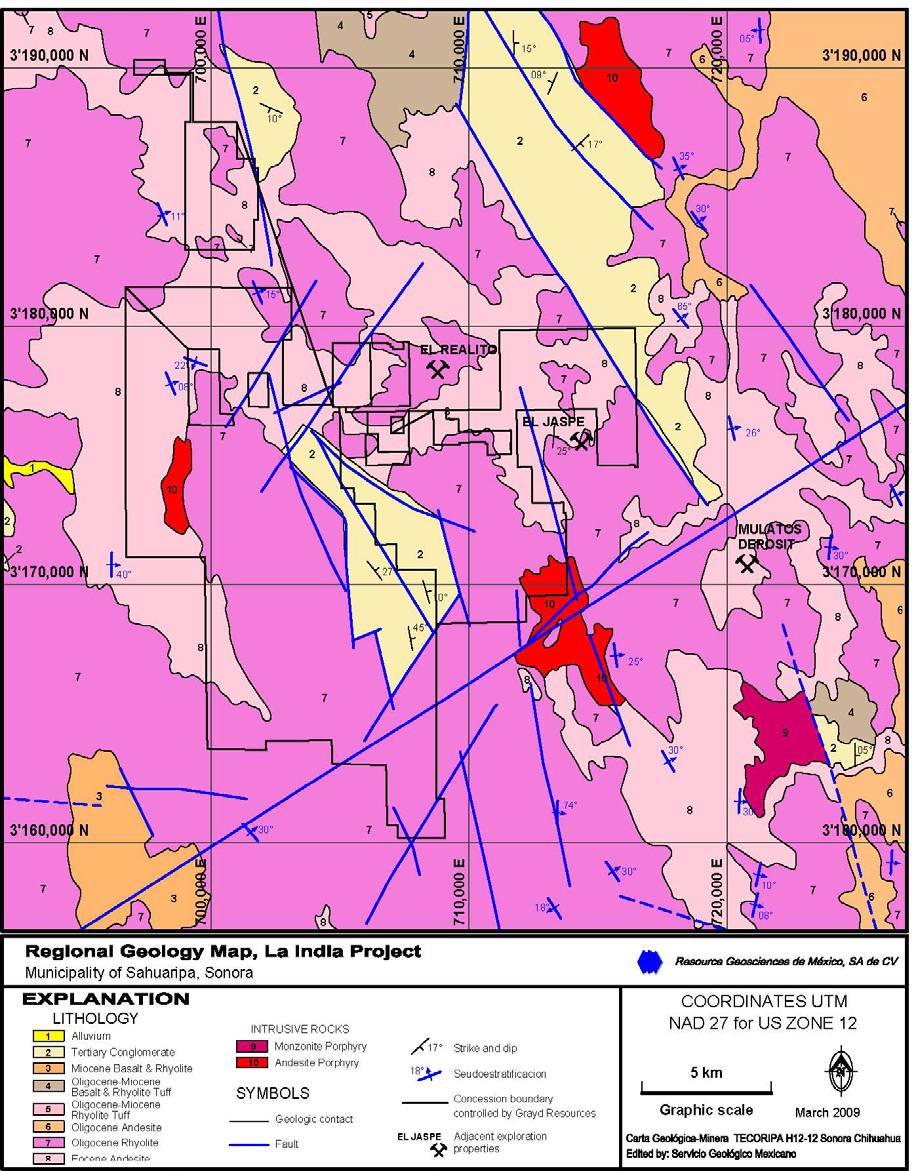
Name: La India
Phase: Operations
Mine Type: Pit
Intro:
The La India property in the municipality of Sahuaripa, Sonora State, Mexico, comprises 57,614 hectares. The property is in the Sierra Madre Mountains of northern Mexico, between the towns of Tarachi and Matarachi, and approximately 210 km east-southeast of the city of Hermosillo. Most basic services are available in Sahuaripa, 15 km to the north. Agnico-Eagle’s Pinos Altos and Creston Mascota mines are 70 km to the southeast.
The topography consists of long ridges separated by steep V-shaped valleys ranging in elevation from 1,200 m to more than 2,000 m above sea level, with areas of low relief suitable for building mine-related infrastructure. The climate is semi-arid, with seasonal temperatures ranging from 35°C to -2°C. The area experiences torrential rainfall from July to September; the driest months are March to May.
-
Name: Pinos Altos
Phase: Operations
Mine Type: Pit, Underground
Intro:
The Pinos Altos property is located in the municipality of Ocampo, in the state of Chihuahua, in northeast Mexico, approximately 220 kilometres west-southwest of the capital city of Chihuahua, 12 kilometres northwest of the town of Ocampo, the municipal centre, and 9 kilometres northwest the village of Cahuisori and nearby Basaseachic.
The Pinos Altos property is located in the Sierra Madre mountain range at relatively high altitude, reaching almost 2500 metres elevation above sea level (“a.s.l.”).
Mineralizations
No mineralizations available.
Placers
No placers available.