Pinos Altos
Phase: Operations
Mine Type: Pit, Underground
Tags: acanthite adularia amethyst andesite apatite breccia chrysocolla conglomerate dacite dickite dyke explosive breccia hematite kaolinite lapilli tuff limestone rhyodacite rhyolite sandstone sericite shale silicification siltstone stockwork tuff visible gold
The Pinos Altos property is located in the municipality of Ocampo, in the state of Chihuahua, in northeast Mexico, approximately 220 kilometres west-southwest of the capital city of Chihuahua, 12 kilometres northwest of the town of Ocampo, the municipal centre, and 9 kilometres northwest the village of Cahuisori and nearby Basaseachic.
The Pinos Altos property is located in the Sierra Madre mountain range at relatively high altitude, reaching almost 2500 metres elevation above sea level (“a.s.l.”).
History:
According to Alvarez (1996), the Santo Niño vein was discovered by Juan Hernández in 1871. It was then acquired by an English mining company, Negociación Minera de Pinos Altos, which was responsible for the first gold rush in the district. From 1890 to 1904, the English company mined a small portion of the Santo Niño vein; work ceased in 1904 due to civil unrest and violence in this period just before the Mexican Revolution. During the period of 1890 to 1904, 18 levels were developed to a depth of 250 metres, along 500 metres of strike length. Ore was extracted via the Victoria adit and processed in the nearby stamp mills located at La Batería.
In 1904, the Santo Niño mine was sold to a North American company, but this company did not carry out any major work and the property was abandoned during the Mexican Revolution (1910-1917).
During the 1930s, a majority of the properties in the Pinos Altos area were acquired and explored by the company, Real Del Norte, however no mining of note was done and the company abandoned the property thereafter.
A second period of mining was led by Juan D. Morales from 1939 to 1958, who discovered the nearby Concheño mining district (approximately 10 kilometres east of Pinos Altos), working the upper level of the existing Santo Niño mine. A mill including a cyanide circuit was built in the vicinity of the present Pinos Altos Ranch site. This operation ceased in 1958. It is estimated (CRM, 1994) that the total production from the Santo Niño vein during both the Morales period ending in the late 1950’s and from the Pinos Altos Company period before the Mexican Revolution was from approximately 350,000 tonnes at grades in the order of 12-15 grams per tonne gold and 80-150 grams per tonne silver for a maximum total of roughly 180,000 ounces of gold and 1.8 million ounces of silver.
During the period of 1960-1980, concessions covering the most interesting mineral occurrences in the Pinos Altos region were consolidated by Adelardo Pérez Campos into Minerales El Madroño S.A. de C.V. (“Madroño”), the lessor of the Madroño Concessions comprising the current Pinos Altos Property. Pérez Campos also built a 100-tonnes-per-day ore processing plant in order to work the concessions and also consolidated most of the surface rights on and around the current Pinos Altos property that were not already granted to the Ejidos by the government following the Mexican Revolution. These properties have remained, in terms of exploration, practically inactive since that time, except for small scale mining activities by Madroño and other artisan miners in the region.
In 1973, Peñoles completed four diamond drill holes on the eastern side of the Reyna de Plata zone (located 1.5 kilometres north of the Santo Niño vein structure) but later dropped its concessions following poor results.
In 1975, the Consejo de Recursos Minerales (CRM) established the area now covered by the Pinos Altos Concession, as a national mineral reserve (thereby restricting exploration in the region). The CRM drilled 9 diamond drill holes in 1991, sunk a shallow inclined shaft (45 metre deep) and completed some minor level developments (approximately 150 metres) on the San Eligio vein but the results were disappointing and work stopped.
In 1993, Peñoles completed a regional geological reconnaissance survey, during which the Santo Niño and Reyna de Plata veins were sampled (Flores 1993).
In 1995, Peñoles entered into an exploration and mineral lease agreement with Madroño for several important concessions covering a portion of the Pinos Altos Property.
The national mineral reserve was dissolved in 1997 and in 1998 mining title to the Pinos Altos Concession was acquired, by way of an auction from the CRM for more than $5.5 million (and a royalty), by Compania Minera La Parreña S.A. de C.V., a wholly owned subsidiary of Peñoles. The concession was then transferred to Madroño who included it in the Madroño Concession Block (leased by contract to Peñoles).
From 1995 to 2003, Peñoles further consolidated the district to form the current Pinos Altos property and undertook modern exploration. The main exploration activities by Peñoles during the period 1995 to 2003 consisted of:
- Regional scale (1:50,000 scale) geological mapping (Trejo, 1999)
- Geological mapping (1:10,000 scale) and sampling of the entire Pinos Altosproperty (Gastellum 1998)
- Detailed geological mapping and sampling of the Santo Niño vein (Zaragoza, 1996; Manríquez et. al., 2000), the Reyna de Plata (Gastellum and Melchor, 1999)
- Rehabilitation of 110-metres of shaft and four levels at the former Santo Niño mine in order to complete underground mapping and sampling of the Santo Niño vein in 1998
- Metallurgical testing of mineral material (934 samples of core) from the Santo Niño and Oberón de Weber veins by Peñoles (CIDT, 1999): Cyanide in bottle-roll test results showed good global recoveries for gold (92.39%; free gold) but poor silver recoveries (47.83%; fine encapsulations in quartz). Column tests of vein material crushed to - 12.7 millimetres indicated recoveries (using 500 ppm NaCN) ranging between 54.4% to 72.8% for gold and 3.6% to 10.3% for silver (60 days)
- From 1995 to 2002, approximately 74,844.3 metres of diamond drilling (235 holes) including 11,213 core samples; exploration was concentrated in the eastern portion of the projects along the Santo Niño and Reyna de Plata structures
- In June 2003 Peñoles completed a mineral resource estimate on the Santo Niño, Oberón de Weber, San Eligio and Reyna de Plata vein zones (Castro et. al. 2003)
- A pre-feasibility level study was also completed in 2006 to determine the potential viability of a 1,500 tonnes per day underground mining operation at Pinos Altos (Peñoles 2003), but no mineral reserves were declared
In 2004, Peñoles completed additional rehabilitation work of the Santo Niño mine workings, namely the Victoria adit and the 1925 metre level, level 1 and level 6, in order to conduct additional channel sampling and geological mapping. A surface mapping and sampling program was also conducted on the Carola vein area in the northwest portion of the property. The results of the exploration program at Pinos Altos were not to Peñoles expectations, and the property was put up for sale in late 2004.
Elsewhere on the property in 1998, Minera Proaño S.A. de C.V. completed detailed mapping and sampling on the Carola concession. Apparently, attractive gold and silver values were reported from the Carola vein with thicknesses reaching 11 metres (Serrano and Herrǎn, 1997; in Castro et. al. 2003). Diamond drilling was planned but none was apparently reported.
In the first quarter of 2005, Agnico-Eagle entered into an exploration and option agreement with Peñoles to acquire the Pinos Altos property. The Company undertook a planned $2.8 million exploration program on the southeast portion of the property in order to expand the mineral resource associated along the Santo Niño fault zone.
In 2005, Agnico-Eagle completed approximately $4.0 million in exploration at Cerro Colorado, Santo Niño and Oberón de Weber zones, specifically:
- Minor rehabilitation work on 1925 metre level of Santo Niño to enable diamond drilling from underground
- 137 diamond drill holes (including 49 holes from underground) (for a total of 19,768.1 metres) that targeted resource conversion and deep exploration and open pit potential
- Baseline environmental studies of the Property (Solano-Rico, 2006)
- Investigation of surface rights
- Scoping study level engineering and metallurgical studies; and
- A mineral resource estimate.
In February 2006, the Company exercised the purchase option for consideration of $32.5 million in cash and 2,063,635 shares of the Company. The transaction closed in March, 2006.
In 2006, a $23 million exploration program was proposed consisting of resource conversion drilling (29,800 metres planned), resource exploration drilling on strike and at depth (21,400 metres planned), completion of a Feasibility Study by mid-2007, and a 1,330 metre exploration ramp at Santo Niño.
Since 2005, Agnico-Eagle Mines has drilled a total of 279 boreholes on Pinos Altos property yielding 50,707 metres.
Regional geology:
Sierra Madre Occidental province
The Sierra Madre Occidental (SMO) province, a regionally extensive Eocene to Miocene volcanic field, which extends southeast from the United States – Mexico border to central Mexico. The total thickness of the volcanic sequence is approximately 2 km, and it rests upon Mesozoic clastic and calcareous sedimentary rock. The volcanic field is comprised of two distinct volcanic sequences, an older andesitic and dacitic series, and a younger pyroclastic-dominated rhyolitic series. The traditional nomenclature refers to these as the Serie Volcanica Inferior (Lower Series) and Serie Volcanica Superior (Upper Series). The Lower Series is approximately 1 km thick and is dominated by Paleocene and Eocene andesitic lavas and pyroclastic deposits, with interbedded volcaniclastic strata. Silicic volcanic units are present but are a minor component. The volcanic strata of the Lower Series are cut by calc-alkaline intrusives. The Upper Series unconformably overlies the Lower Series with erosional disconformity, and comprises a 1-km-thick sequence dominated by Oligocene and early Miocene dacitic and rhyolitic pyroclastic strata and volcaniclastic strata. Most significant metal occurrences in the SMO are hosted by rocks of the Lower Series or the underlying Mesozoic strata.
Regional stratigraphy :
On a regional scale, the SMO is a relatively undeformed high plateau (Henry and Aranda-Gomez, 1992). Overall, there is a northwest-trending structural fabric best evidenced by the alignment of the numerous mining districts found in the SMO. According to Bockoven (1980), the most important structures in the Ocampo-Yécora area are related to the development of calderas and Basin and Range type of normal faulting, which the Ocampo caldera, of 40-50 km in diameter, is the most obvious morphostructural element. From the satellite work it appears that Ocampo lies near the centre of a major caldera and is surrounded by at least two others. Henry and Aranda-Gomez suggest that the SMO is relatively undeformed due to the presence of a large batholith that underlies it. This inferred batholith is believed to be source of the very large volume of volcanic rocks. Structures in the basement are more difficult to find due to the lack of outcrops of old rocks, although Mullan and al. (1978) have interpreted a polyphased deformation associated with the Nevada and Sonoma Orogenies in the metamorphic rocks of the La Nopalera region. Zaragoza (1997) interpreted the structural succession as follows, from oldest to youngest event:
- NNW fault system that provides a feeding trough for caldera generator magmas
- Holding of the Navasaigame conglomerate, with northwest tendency, related to the Laramide Orogeny
- Caldera-related structures
- Younger northwest fault system
- Basin and Range type of extensional faults which generate the NW30° (trend) of the Sierra, some of them intersect and reactivate structures associated with caldera, and generate grabens like the one east of Yécora and in the Yepachic-Pilares region
Local geology:
Lithology .
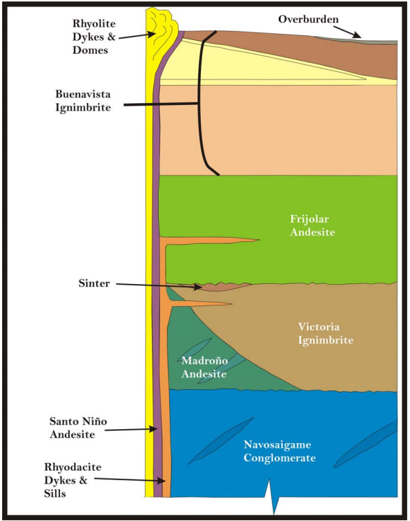
The Pinos Altos property is host to volcanic rocks belonging to both the Upper Volcanic Group (UVG) and the Lower Volcanic Group (LVG). The Lower Volcanic Group is represented on the property by the Navosaigame conglomerates and the El Madroño volcanics. These units represent episodes of erosion and andesite dominated volcanism. The Upper Volcanic Group discordantly overlies rocks of the Lower volcanic sequence. The Upper Volcanic Group is made up of the Victoria ignimbrites, the Frijolar andesites and the Buenavista ignimbrites. Intermediate and felsic dykes as well as rhyolitic domes intrude all of these units. Lacustrine deposits are also locally recognized.
Upper Volcanic group (<38Ma):
- Buenavista Ignimbrite - 570 m-Pale brownish gray, beige rhyodacite crystal lithic tuffs and lapilli tuffs.
- Frijolar andesite - 420m-Brown, purple andesite lithic flow tuffs
- Victoria Ignimbrite - 400m-Buff, brownish-gray rhyolite and dacitic crystal lithic ash flow tuffs
Lower Volcanic Group (>45Ma):
- El Madroño Volcanics - 250-750m-Interbedded greenish-gray andesite and rhyolite flows and volcanoclastics
- Navosaigame Conglomerate - 420m-Mostly purple conglomerates, sandstones, shales
The Navosaigame conglomerate of the LVG is made up of thinly bedded sandstone intercalated with siltstones and conglomerates. Clasts consist of andesite, limestone, granitoids and quartzofeldspathic gneisses. Some sandstone horizons also contain pumice fragments. The El Madroño volcanics consist of andesitic tuffs and lavas intercalated with rhyolitic tuffs and sandy volcanoclastic and sediments. The andesitic tuffs are greenish grey. Feldspar and biotite phenocrysts are as common as andesite and pumice lithic fragments. The andesitic flows consist of intercalations of agglomerates and massive porphyritic layers. Plagioclase and ferromagnesian oxides occur as phenocrysts in a light green aphanitic matrix. Intercalated within these flows are at least two rhyolitic tuff horizons, which can reach up to 50 m in thickness. These horizons are commonly argillite altered and weakly oxidized. Thinly laminated medium to coarse grained sandstone horizons of less than 10 m in thickness are also noted.
The UVG discordantly overlies rocks of the LVG. The Victoria ignimbrites represent an explosive felsic volcanic event. Layers within this unit present numerous textural, compositional and colour variations. Rocks within this unit include vitrocrystalline and lithic tuffs of rhyolitic to dacitic composition, aphanitic vitreous tuffs, pyroclastic lithic tuffs ranging up to lapilli tuffs with fragments of variable composition and volcanic breccias. The Frijolar andesite are massive to flow banded, porphyritic, consisting of 70% plagioclase and hornblend phenocrysts in a brownish to purple aphanitic groundmass locally hosting pyrite and hematite. The Buenavista ignimbrite consists of a series of dacitic to rhyolitic pyroclastics. From top to bottom, the layers encountered are:
- Basaltic flows: Blackish coloured, aphanitic and amygdaloidal
- Dacitic flows: Purple to maroon in colour and for the most part aphanitic, but locally plagioclase porphyritic. Flow banding and flow breccias are sometimes discernable.
- Lapilli and sandy tuffs
- Vitrocrystalline lithic welded tuffs: Beige to pinkish beige colour, with quartz, feldspar and biotite phenocrysts and 10 to 25 % lithic and pumice fragments.
- Rhyodacitic vitrocrystalline tuffs: Beige to purple in colour, with more than 10% of quartz, feldspar, plagioclase and biotite phenocrysts. For the most part massive, breccias with fragments of equal composition as the matrix are developed near the base of the unit.
The Lacustrine deposits (Sinter) consist of layers of finely laminated fine-grained grey to black, silica-rich beds intercalated with volcanic and limestone layers. The intrusive rocks are represented by the rhyolite and Santo Niño andesite units. The rhyolites are present as dykes and small domes. These units intrude the Victoria and Buenavista ignimbrites close to the Santo Niño and Reyna de Plata fault zones as well as close to other minor structures. The unit is white to reddish beige, aphanitic to porphyritic and with well developed flow banding. Fine-grained disseminated pyrite is commonly associated with these rhyolites. The Santo Niño andesite is a dyke that intrudes along the Santo Niño fault zone. It is
purple to greenish mauve colour, fine to medium grained and with plagioclase and hornblend phenocrysts. Rhyolite and andesite dykes are embedded along faults that cut the above series. Quartz-gold vein deposits are embedded along the Santo Niño and Reyna de Plata faults and along transfer faults that splay northwest from the Santo Niño fault.
Structure:
The Pinos Altos property is centred on a horst structure striking at an azimuth of roughly 120 degrees. The horst is defined by the Reyna de Plata fault to the north and the Santo Niño fault to the south (Figure 16). Within this context, the principal veins and faults are grouped as follows:
- WNW pre-mineralization, numerous re-activation episodes
- North to northeast, pre-and post-mineralization
- North to NNE pre- and post-mineralization, low angle fault, seen only at theCarola fault
- North to NNW post-mineralization, basin and range type structures
The mineralization is controlled by the WNW and the NNE system. The Santo Niño and Reyna de Plata faults represent the WNW system. These faults run sub-parallel to each other and can be traced for up to 7 kilometres. As previously mentioned, the principal gold occurrences on the property are hosted by the Santo Niño fault zone. Numerous episodes of movements are interpreted, including a pre-mineralization sinistral to normal movement during a NNW–SSE extension period and a post-mineralization dextral movement during a northeast–ENE extensional period. The north-northeast faults were also important to the emplacement of gold on the property. It is at the intersection of two structures, the Victoria and the El Comedero faults with the Santo Niño fault zone, that are respectively located the Santo Niño and the Oberón de Weber ore shoots.


Deposit geology:
The veins have a variable thickness (1 to >20 m) and are often surrounded by low-grade or barren stockworks (20-40 m). The mineralization is emplaced along a WNW trending regional Santo Niño fault. The ore structure outcrops over a distance of roughly 6 km. It strikes at N060º degrees azimuth on its eastern portion and turns to strike roughly N090º azimuth on its western fringe. The structure dips at 70º towards the south. The four mineralized sectors hosted by the Santo Niño structure consist of discontinuous quartzrich lenses named from east to west: El Apache, Oberón de Weber, Santo Niño and Cerro Colorado.
The four zones are described, from most to least important in size:
The Santo Niño zone
The Santo Niño lens dips towards south. It follows the Santo Niño fault, which is not mineralized, and is surrounded by the Buenavista ignimbrite (hanging wall) to the south and by the Victoria Ignimbrite (footwall) to the north. The host rock is the Santo Niño Andesite and, more rarely, the Victoria ignimbrite. Beyond its western and eastern extents, the Santo Niño Andesite is massive and only weakly altered (propylitisation, hematisation and argilitization).
The Santo Niño lens is the most vertically extensive. Few holes were intersected in the zone at a depth of roughly 750 m below the surface. The vein follows the surface over a distance of 550 m and discontinuously up to 650 m. In the first 250 m, the width is up to 50 m. Between 250 and 550 m, it increases to a maximum of 40 m and reduces to 3 m in depth. Each of the zone extremities presents an average width of 3 m.
In the mineralized zone, these units have stockworks or are strongly brecciated (replacement and open space filling breccia sub-unit). The gold grades are systematically associated with the green quartz brecciated andesite. In depth, the brecciated Victoria Ignimbrite is occasionally mineralized and formed secondary smallest lenses shown in Figure 30. The spatial relationship of gold grades with the hanging wall and footwall is not consistent. Near the surface, in holes PA-05-21, PA-05-20, PA-05-09 and BSN59, the higher grades are in contact with the hanging wall but progressing at depth through hole PA-05-11, two higher grade zones are discernable within a wide, strongly goldenriched envelope. The first zone is still in contact with the hanging wall, but a second higher grade zone that does not appear in the more shallow holes is developed close to, but not in contact, with the footwall.
The Oberón de Weber zone
The Oberón de Weber ore zone is very similar to the Santo Niño ore zone except that it is smaller and the green quartz breccia and stockwork sub-units are less abundant. The lens
presents a displacement in the middle caused by a northeast fault.
The zone is followed on the surface and by diamond drilling over roughly 700 m. Shallow holes drilled by Agnico-Eagle show good continuity both in grade and thickness of over roughly 550 m. The zone width is approximately 5 m in its extremities, at surface and in depth. In the middle of the zone, the width increases to 25 m. From previous drilling done by Peñoles, continuity at depth appears to be erratic with a weakly defined western rake.
The Cerro Colorado zone
The Cerro Colorado lens is structurally more complex than the two zones described above. Its relation to the Santo Niño fault zone is not clearly defined and the host rock appears to be principally massive Victoria Ignimbrite. Near the surface, it is marked by a complex superposition of northwestern brittle faults with mineralized zones which are difficult to correlate from hole to hole. The green quartz breccia and stockwork are uncommon and not systematically mineralized.
The principal zones are situated in depth between 70 and 300 m and are not really exposed at the surface. Their width varies from 4 to 20 m and their extent is 520 m. Two deeper holes done by Agnico-Eagle during the last campaign suggest better grade continuity at depth.
San Eligio zone
The San Eligio zone is located approximately 500 metres north of Santo Niño. The host rock is brecciated Victoria Ignimbrite with, rarely, stockworks. There is no andesite in this sector and no fault oriented WNW as observed in other lenses. Unlike the other lenses, the San Eligio lens dips towards the north. Like the Oberón de Weber lens, the San Eligio lens is displaced by a fault.
The lateral extent seems to be continuous at 850 m. Its average width is 5 m and never exceeds 15 m. Surface mapping and prospecting has suggested good potential for additional mineralization on strike and at depths below 150 metres. Visible gold has been seen in the drill core.
El Apache zone
The El Apache zone is the most poorly mineralized. The area hosts a weakly developed white quartz dominated breccia in andesite dyke. The Santo Niño fault is observed but is not as continuous as in the Santo Niño zone. The average lens thickness is 7 m. Gold values are low and erratic over its roughly 300 m strike length. Past drilling suggests that this zone has limited extent at depth (approximately 250 m).
Other gold zones
The Carola area is located in the northwestern part of the Pinos Altos property, at approximately 6 km northwest of the Santo Niño ore zone. There are two interesting zones in this sector: Mascota and Crestón Colorado. These lenses are very close to the surface, within the first 90 m, and are characterized by their low dipping strike. Many faults controlled their emplacement, principally the north-south and WSW faults. The zones are hosted in felsic pyroclastic rocks. They present great gold values and are developed in white quartz breccia and stockworks sub-units which exhibit vuggy and open space filling textures.
Mineralization:
All four lenses share a similar multi-episodic history as described by Peñoles reports.
- Formation of the Santo Niño fault
- Intrusion of Santo Niño andesite dyke within the Santo Niño fault Succession of brechification episodes in Santo Niño andesite and Victoria ignimbrite with formation of vuggy cockade quartz. These breccias are usually strongly oxidized along fractures and are marked by fine pyrite disseminations (less than 1%). Visible gold is sometimes noted within these breccias.
- Formation of green quartz breccias. The quartz-adularia matrix hosts strongly silicified wallrock fragments from the Santo Niño andesite and the Victoria ignimbrite. The matrix consists of banded coloform and crustiform, locally drusitic green quartz. Traces of pyrite and visible gold are noted. Native silver and electrum were noted in higher grade holes.
- Late Stage Breccia event. A late breccia event consisting of grey to yellowish green quartz with local amethyst. This quartz cements fragments of all units described above. Grey to
blackish gray calcite is also associated with this event. Late brittle fault gouges along the Santo Niño fault within which mineralized rock fragments are sporadically noted.
The minerals present are indicative of an oxidized, epithermal, low-sulphidation (and likely low sulphide) precious metals vein rich in silver. Temperature of formation is below 300ºC, as no selenium minerals were found in the EDX study done by CGF Geological Consultants (CGF, 2005). Kaolinite and dickite are indicative of an acidic environment. The presence of hematite crystals in the centre of acanthite indicates that the deposit was probably formed under oxidative conditions. Carbonate in the system probably came from alteration of the volcanic protolith.
One sample from hole PA-05-03 was submitted for a petrographic description. Ore minerals observed under the petrographic microscope were native gold, native silver and acanthite, a low-temperature modification of silver sulfide. The gold and silver in the mineralized lenses is disseminated in green quartz brecciated sub-units. The gangue included quartz, kaolinite, hematite, and minor apatite and chrysocolla.
Acanthite fills spacing between quartz grains and crystals. Silver occurs as replacement rims on the acanthite. Gold occurs as small, sub-millimetre grains either as floaters in quartz matrix or rarely associated directly with silver minerals.
Hematite and chrysocolla form by oxide replacement of early sulfide phases, hematite from pyrite and chrysocolla, presumably from stromeyerite or chalcopyrite. Neither sulfide phase was observed through microscopic examination, but was noted during core logging.
Deposit types:
The Pinos Altos property is a classic gold-silver epithermal deposit, generally classified as a pluton-related adularia-sericite system. These deposites are developed during an extension event, sub-aerial calderas formed along the Sierra Madre Occidental in the caldera called Ocampo, which is a multi-caldera favourable for the formation of this type of deposit.
Based on mineralogy and alteration, gold-silver mineralization is a low-sulphidation quartz-adularia type. The system contains quartz vein stockworks, and breccias carrying gold, silver, gold and silver tellurides, and lesser and variable amounts of pyrite, chalcopyrite and rare sulfosalt minerals forming in near-surface environment. The hosted rock commonly exhibits breccia and open space filling textures. The mineralization is associated with volcanic-related hydrothermal to shallow depth and low temperature geothermal system.
All deposits are associated to the WNW-ESE faults and brecciated andesite dyke (Santo Niño Andesite) or welded pyroclastic deposits (Victoria Ignimbrite). Buenavista Ignimbrite is always barren. The degree of brechification varies from stockwork, replacement breccia to open space filling breccia.
Mineral Resources (Aug. 9, 2007)
| Class | Ore (ktonnes) | Au grade (g/t) | Au (kg) | Au (oz * 1000) | Ag grade (g/t) | Ag (kg) | Ag (oz * 1000) |
|---|---|---|---|---|---|---|---|
| Inferred | 3008.00 | 2.83 | 8512.64 | 274.00 | 80.28 | 241482.24 | 7765.00 |
| Indicated | 2570.00 | 1.92 | 4934.40 | 158.00 | 74.35 | 191079.50 | 6115.00 |
Reserves (Aug. 9, 2007)
| Class | Ore (ktonnes) | Au grade (g/t) | Au (kg) | Au (oz * 1000) | Ag grade (g/t) | Ag (kg) | Ag (oz * 1000) |
|---|---|---|---|---|---|---|---|
| Probable | 19957.00 | 3.47 | 69250.79 | 2224.00 | 102.33 | 2042199.81 | 65654.00 |
Source:
-
Pinos Altos gold-silver project Chihuahua state, Mexico 2007 technical report on the mineral resources and reserves
(24.09.2007, Preissac)
Authors: Doucet Daniel, Grondin Louise, Matte Pierre, Prince Camil