La India
Phase: Operations
Mine Type: Pit
Tags: alunite andesite argillic alteration conglomerate dacite dacite porphyry dickite diorite eocene hydrothermal breccia lapilli tuff lava miocene molybdenite oligocene paleocene pyrophyllite rhyolite sericite silicification stock stockwork tourmaline trachyandesite tuff
The La India property in the municipality of Sahuaripa, Sonora State, Mexico, comprises 57,614 hectares. The property is in the Sierra Madre Mountains of northern Mexico, between the towns of Tarachi and Matarachi, and approximately 210 km east-southeast of the city of Hermosillo. Most basic services are available in Sahuaripa, 15 km to the north. Agnico-Eagle’s Pinos Altos and Creston Mascota mines are 70 km to the southeast.
The topography consists of long ridges separated by steep V-shaped valleys ranging in elevation from 1,200 m to more than 2,000 m above sea level, with areas of low relief suitable for building mine-related infrastructure. The climate is semi-arid, with seasonal temperatures ranging from 35°C to -2°C. The area experiences torrential rainfall from July to September; the driest months are March to May.
History:
The first gold discovery in the region, as recorded by Spanish colonials, was made in 1673 at Ostimuri. The gold deposit at Mulatos was discovered by the Spaniards in 1806, but it is likely that indigenous peoples exploited the native gold-bearing oxidized zone of the Mulatos deposit prior to the colonial epoch. Small-scale mining has been semi-continuous in the district during the last two centuries (Consejo de Recursos Minerales, 1992). Much of the early mining and all of the small-scale present mining (hand-mining by local artisanal miners) targets oxidized fractures containing fine-grained visible gold. The mineralization described for the mines in this section is not necessarily indicative of the mineralization at the La India, Sonora property.
The most significant mining activity in the region has been from the Mulatos gold deposit, located 6.5 km from the property, which is reported to have produced over 400,000 oz gold prior to 1905 (Southworth,1905). Alamos Gold Inc., a TSX traded public company, now controls the Mulatos deposit and operates a large-scale open pit mine there.
Past mining activity on the present La India property included small underground mines and work on prospects throughout the La Cruz and La Viruela areas. Local residents state that the La Cruz - La Viruela property was intermittently mined at a small scale during the early 1920s and 1930s. On the basis of the size of the mine workings, the author estimates no more than 10,000 tonnes of material was extracted from all of the historic workings in the La Viruela -La Cruz area. There has been modern exploration work in this area.
In the late 1980s, New Golden Sceptre Minerals and New Goliath Minerals completed approximately 2,000 m of percussion drilling. In the early 1990s Noranda acquired the rights to La Cruz - La Viruela and completed 2,616 m of reverse circulation drilling. Drill logs and assay results generated by these drill programs are not available, but Jenkins (1994) reported that at least 72 holes were drilled, with at least 32 drill holes located in the La Viruela area and at least 35 at La Cruz. The drill holes at La Viruela ranged from 20 to 126 m in depth, whereas the drill holes at La Cruz ranged from 21 to 102 m depth. Jenkins (1994) summarized drill results indicating that intercepts of >0.3 g/t gold were common, with the most significant reported intercepts at La Viruela being 52 m @ 1.03 g/t and 38 m @ 2.68 g/t gold, whereas at La Cruz, the most significant drill intercepts were 20 m @ 6.15 g/t and 24 m @ 1.17 g/t gold.
In 1993 San Fernando Mining Co. Ltd. acquired the property and conducted further drilling, including 10 diamond drill holes totaling 2,268 m at La Viruela and 11 diamond drill holes at La Cruz totaling 1,292 m (McDougall, 1995). Drill logs and assay results generated by the drill programs are not available, but McDougall (1995) reported that the most significant intercepts generated by San Fernando Mining Company Ltd. were 28 m @ 1.96 g/t gold at La Viruela and 27.5 m @ 2.24 g/t gold at La Cruz.
Grayd Resource Corp. actively explored the project from 2004 through its wholly-owned Mexican subsidiary, Resource Grayd de Mexico SA de CV (Grayd Mexico), until Grayd was acquired by Agnico-Eagle in November 2011. Work completed by Grayd included geologic mapping, geochemical rock-chip sampling, airborne geophysical surveys, ground geophysical surveys, photogrammetric topographic mapping, diamond drilling, reverse circulation drilling, baseline environmental surveys, and metallurgical testing. The exploration work from January 2004 through mid-2010 was described in “6 December 2010 Preliminary Economic Assessment, La India Gold Project, Municipio of Sahuaripa, Sonora, Mexico” (Gray et al., 2010). 169 diamond drill holes were drilled for a total of 20,001 metres and 633 reverse circulation drill holes for a total of 65,274 metres.
Regional geology:
Sierra Madre Occidental province
The Sierra Madre Occidental (SMO) province, a regionally extensive Eocene to Miocene volcanic field, which extends southeast from the United States – Mexico border to central Mexico. The total thickness of the volcanic sequence is approximately 2 km, and it rests upon Mesozoic clastic and calcareous sedimentary rock. The volcanic field is comprised of two distinct volcanic sequences, an older andesitic and dacitic series, and a younger pyroclastic-dominated rhyolitic series. The traditional nomenclature refers to these as the Serie Volcanica Inferior (Lower Series) and Serie Volcanica Superior (Upper Series). The Lower Series is approximately 1 km thick and is dominated by Paleocene and Eocene andesitic lavas and pyroclastic deposits, with interbedded volcaniclastic strata. Silicic volcanic units are present but are a minor component. The volcanic strata of the Lower Series are cut by calc-alkaline intrusives. The Upper Series unconformably overlies the Lower Series with erosional disconformity, and comprises a 1-km-thick sequence dominated by Oligocene and early Miocene dacitic and rhyolitic pyroclastic strata and volcaniclastic strata. Most significant metal occurrences in the SMO are hosted by rocks of the Lower Series or the underlying Mesozoic strata.
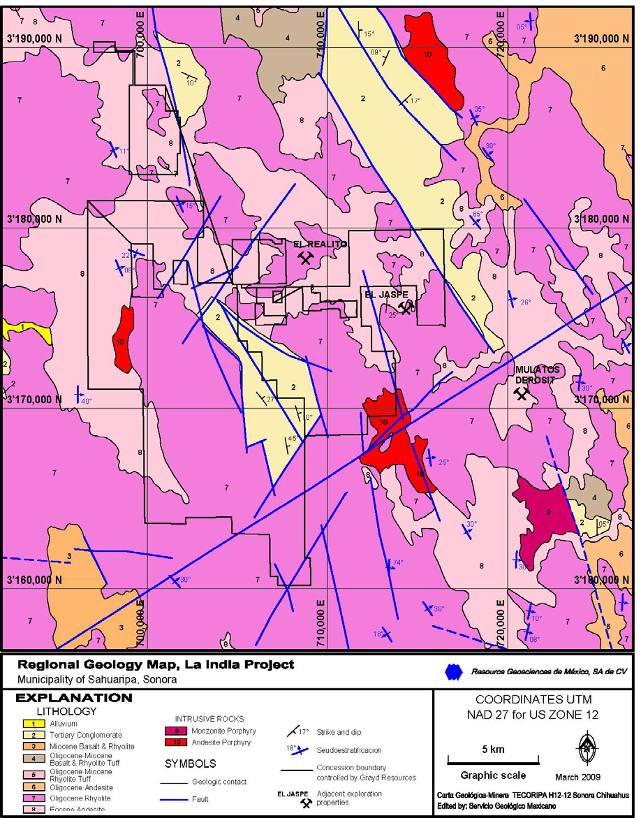
Regional stratigraphy :
On a regional scale, the SMO is a relatively undeformed high plateau (Henry and Aranda-Gomez, 1992). Overall, there is a northwest-trending structural fabric best evidenced by the alignment of the numerous mining districts found in the SMO. According to Bockoven (1980), the most important structures in the Ocampo-Yécora area are related to the development of calderas and Basin and Range type of normal faulting, which the Ocampo caldera, of 40-50 km in diameter, is the most obvious morphostructural element. From the satellite work it appears that Ocampo lies near the centre of a major caldera and is surrounded by at least two others. Henry and Aranda-Gomez suggest that the SMO is relatively undeformed due to the presence of a large batholith that underlies it. This inferred batholith is believed to be source of the very large volume of volcanic rocks. Structures in the basement are more difficult to find due to the lack of outcrops of old rocks, although Mullan and al. (1978) have interpreted a polyphased deformation associated with the Nevada and Sonoma Orogenies in the metamorphic rocks of the La Nopalera region. Zaragoza (1997) interpreted the structural succession as follows, from oldest to youngest event:
- NNW fault system that provides a feeding trough for caldera generator magmas
- Holding of the Navasaigame conglomerate, with northwest tendency, related to the Laramide Orogeny
- Caldera-related structures
- Younger northwest fault system
- Basin and Range type of extensional faults which generate the NW30° (trend) of the Sierra, some of them intersect and reactivate structures associated with caldera, and generate grabens like the one east of Yécora and in the Yepachic-Pilares region
Local geology:
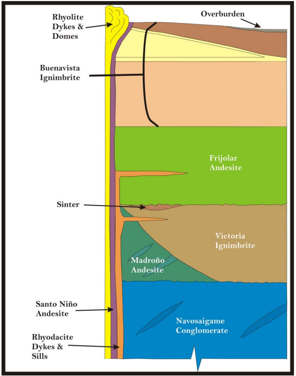
The La India project area is underlain by the Lower Series volcanic sequence comprised of Paleocene andesitic and dacitic volcanic rocks interbedded with epiclastic rocks of similar composition. The andesitic volcanic rocks are the oldest Cenozoic rocks at La India and include a lower sequence of lavas, tuffs and epiclastic rocks. Atop the andesite is an upper sequence of biotite-pyroxene trachyandesitic and dacitic flow domes and tuffs. These rocks overlie the lower andesites with erosional disconformity; fine-grained dacitic tuffs interbedded with epiclastic rocks mark the contact. Two 40Ar/39Ar age determinations on plagioclase returned Paleocene ages for the lower andesitic and upper dacitic sequences (62.6 Ma and 55.8 Ma, respectively). Dacite and feldspar porphyries intruded the andesitic and dacitic volcanic rocks at La India (Longo, 2006a; Longo et al., 2010), and a granodiorite intruded andesitic volcanic rocks at the southern limit of the project area (Moore, 2006). Two 40Ar/39Ar ages of plagioclase from the porphyries yielded Eocene ages of 43.3 Ma and 36.9 Ma. Thick (100-500-m) deposits of rhyolitic ignimbrite overlie the older andesite and dacite. These rocks are named the Nopal Ignimbrite, and one 40Ar/39Ar age of biotite yielded an upper Eocene age of 33.9 Ma.
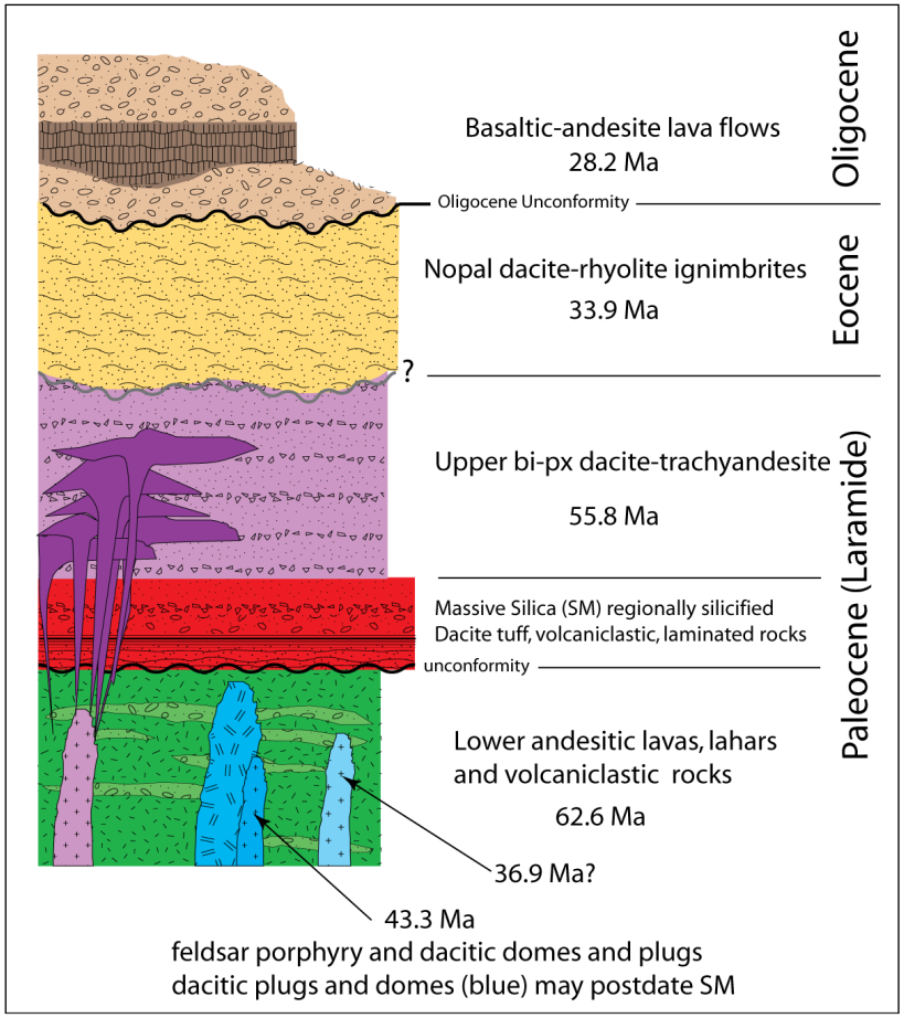
Upper Series rocks include basaltic andesite lavas and flow breccias that overlie the Nopal ignimbrites with erosional disconformity. One 40Ar/39Ar age from a wholerock sample of lava yielded an Oligocene age of 28.2 Ma. These lavas are both overlain by and interbedded with alluvial conglomerates. Upper Series Oligocene rhyolitic ignimbrites have not been recognized within the concession boundaries. The rocks at La India strike northwest and dip 25 to 30 degrees northeast in the southern portion of the project area (Moore, 2005), and dip 15 to 25 degrees west and southwest in the northern portion of the project area. The La India - La Viruela - La Cruz area comprises one of several high-sulphidation epithermal mineralization centres recognized in the Mulatos district (Staude, 2001).
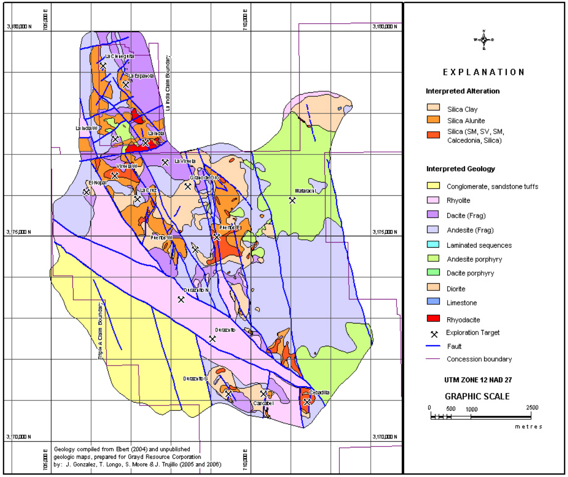
Silica alteration is both stratiform and discordant. Stratiform layers of silica are localized at the base of the dacitic tuffs within the epiclastic rocks. Silicification coincident with zones of higher grade gold mineralization is controlled by high angle faults and fractures. Geological mapping and surface rock chip sampling have identified zones of gold-bearing silica, silica alunite, and argillic alteration from numerous localities within the project area. The most extensive surface outcrops of altered and gold-bearing rock are found at the La India, La Viruela, La Cruz, Cerro de Oro, Espanola, Cieneguita, Espanola, and Cochis areas; these have been the focus of drill testing, and host the mineral resource described in this report. Another zone of outcropping gold mineralization has been identified at the Los Tubos area located 2 km east of the La Cruz area. This area offers potential to host additional resources, but this target has only been partially drill-tested and a resource has not been demonstrated.
Mineralization:
Numerous epithermal gold occurrences are exposed in small abandoned mines or exploration workings throughout the La India property. Host rocks include hydrothermal breccias, andesite, dacite porphyry, and volcaniclastic strata. Both high-angle structural and low-angle stratigraphic controls are observed. Mineralized zones are characterized by alteration mineral assemblages that include alunite, dickite and/or pyrophyllite, accompanied by intense silica replacement of the host rock, with variable intensities of pyritization and/or hematization. Pyrite occurs both as disseminations and in microveinlets. In oxidized zones, relict hematite-limonite-goethite after pyrite is present. In some occurrences, primary hypogene specularite is associated with auriferous zones.
North Zone comprising Cieneguita, Española, Cochis and La India area
The North Zone is underlain by andesitic and felsic fragmental volcanic strata. Stratigraphically controlled zones of silica alteration and gold mineralization are restricted to the felsic units and outcrop extensively at the Cieneguita, Española, and Cochis areas. The mineralized strata dip gently to the west, and the silicified zones outcrop as prominent ridge-capping units and dip slopes. The silicified strata are 30 to 60 m thick, with down-dip extent of 300 m or more. The La Cieneguita zone is semi-continuously exposed for over 1,300 m of strike length; erosional or fault-offset remnants of the silicified zone are exposed at the Española and Cochis areas located to the east and southeast, respectively. Oxidation is intense and complete throughout the total thickness of the mineralized zone.
The inactive La India mine workings are developed in argillized porphyritic dacite intrusive that underlies silicified felsic fragmental strata. The silicification appears to be controlled by both stratigraphy and high-angle structures, and may be part of the silicified zone exposed to the north at the La Española and La Cieneguita areas. In contrast to other mineralized zones in the region (where gold is generally restricted to silicified zones), at the inactive La India mine significant gold mineralization occurs in argillized volcanic units. The La India area is also unusual in that thus far, it is the only gold occurrence in the project area that is also associated with disseminated copper mineralization; drilling has demonstrated a gold-copper-molybdenum metal assemblage in mineralized porphyry. Gold and copper mineralization is associated with quartz stockwork veinlets in the dacite with quartz-sericite-tourmaline alteration. Coxcomb textured and drusy quartz veins with molybdenite and pyrite that resemble D-veins in the dacite porphyry are found at depths of 200 to 300 m below surface.
North Zone mineralization type domains have been defined on the basis of alteration mineral assemblages and the form or control of gold occurrence (Smit, 2008). The domain definitions have been reviewed, and the mineralization type domains identified are appropriate for the deposit and valid for resource estimation purposes. The domain descriptions presented by Smit (2008 and personal communication) are summarized as follows:
- Domain 11: Variably silica- and/or clay-altered dacite / dacite tuff. Stratigraphically overlies the silicified dacite of Domain 12 and is probably the less altered equivalent.
- Domain 12: Massive silica+alunite-altered dacite tuff. Crosscutting field relationships indicate that the massive silicification preceded the economically important gold deposition events, and this unit is generally not significantly mineralized unless it is crosscut by high-angle structures and fracture zones. Forms tabular continuous sheets that typically form dip slopes and blanket the topographic surface. For purposes of metallurgical testing, this domain was subdivided into Domain 12 comprised of material dominated by silica and Domain 12A comprised of a mixture of silica and alunite. The silica-rich Domain 12 has higher densities and lower average gold recoveries than Domain 12A.
- Domain 14: Silica-clay-altered andesite, forming a stratiform and strata-bound layer lying beneath the lower contact of the dacite unit of Domain 12 or Domain 18. The zone is typically
less than 10 m thick and exhibits a rapid gradational contact with increasing depth to unmineralized andesite. - Domain 17: Mineralized porphyry comprising andesitic-dacitic feldspar porphyry that hosts disseminated, stockwork, and irregular structurally controlled gold mineralization with associated copper and molybdenum, occurring in the vicinity of the inactive La India mine workings.
- Domain 18: Silicified and clay-altered breccia, controlled by low-angle structural zones, continuous and correlated between drill holes only in the north part of the Cieneguita area. Occurs at the base of Domain 12 and is observed in drill core and underground workings as a zone of brecciated massive silicified dacite and the underlying silica- and clay-altered andesite, containing abundant hematite in fractures.
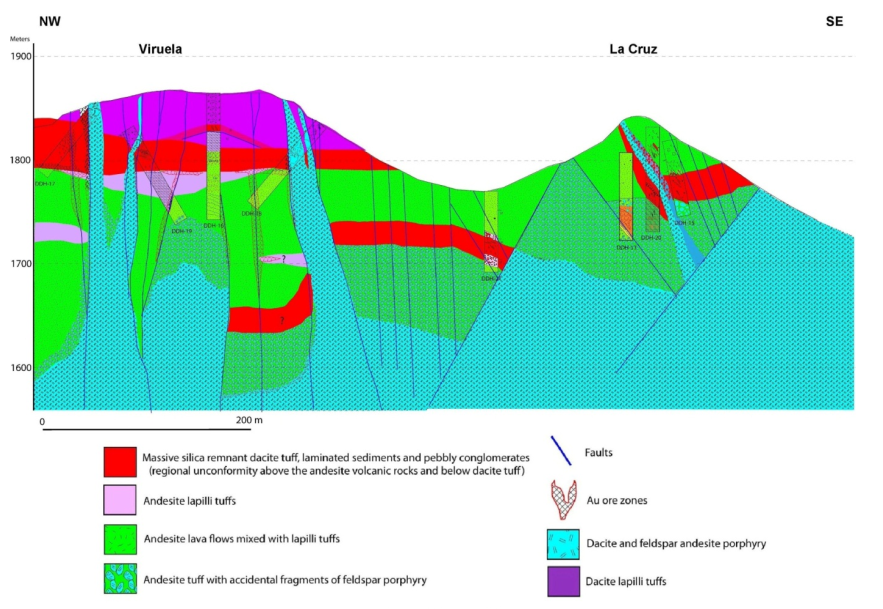
Main Zone comprising La Viruela, La Cruz and Cerro de Oro areas
The Main Zone target area is comprised of the La Viruela, La Cruz, and Cerro de Oro areas where gold concentrations are hosted by six distinct mineralization type domains. The domains were defined on the basis of alteration mineral assemblages and the form or control of gold occurrence (Smit, 2008). These domain definitions have been reviewed, and the mineralization type domains identified are appropriate for the deposit and valid for resource estimation purposes. The domain descriptions presented by Smit (2008 and personal communication) are summarized as follows:
- Domain 1: Dacite unit, variably altered to silica, clay and alunite mineral assemblages, in the La Viruela and La Cruz areas. This domain is defined both by lithology and alteration. Alteration is most intense in areas of high-angle structures and is in general most intense in the La Viruela area. Where quartz phenocrysts are preserved, conclusive identification of the dacite is possible, whereas in other cases the unit is defined on the basis of its consistent stratigraphic position overlying the Domain 2 stratiform massive silica unit.
- Domain 2: Massive silica unit, developed primarily in dacitic tuff, but also may be developed in contact zone with andesites and dacites in the La Viruela and La Cruz areas. Forms intense stratiform zones of silica-replaced rock, locally with hydrothermal clays. Field relationships indicate that the massive silicification predated the economically important gold deposition event. For purposes of metallurgical testing, this domain was subdivided into Domain 2 comprised of material dominated by silica, and Domain 2A comprised of a mixture of silica and alunite. The silica-rich Domain 2 has higher densities and lower average gold recoveries than Domain 2A
- Domain 3: Vuggy silica – silica-alunite unit. Silica-alunite-altered rock, typically developed in fine grained andesite tuffs, often with distinct vuggy silica texture, found in the La Viruela
area. Mapping and drill-hole data demonstrate that the distribution of this unit is controlled by high-angle northeast-striking structures and by the lower contact of the Domain 2 massive silica unit. It typically forms an irregular layer developed at the base of Domain 2 in the La Viruela area and narrow high-angle tabular bodies that follow northeast structures. A silica- clay-altered andesite zone is present at La Viruela, occurring in gradational contact with the lower contact of Domain 3, reflecting a decreasing alteration intensity in the andesite tuff. In the La Cruz area, it occurs at the base of the Domain 2 massive silica unit. In the 2009 resource model this material was modeled separately as Domain 4, but subsequent drilling and analysis showed that the silica-clay-altered zone is a gradational zone at the boundary of the other domains, is volumetrically insignificant, and cannot be accurately modeled as a distinct unit. Therefore, Domain 4 is no longer used in the resource model, and the mineralized silica-clay-altered zones at the periphery of Domains 2 and 3 are included within the respective domains. - Domain 5: Silica-clay-altered andesite with structurally controlled mineralization, found in the Cerro de Oro and La Cruz areas, comprised of silica-clay-altered andesite with irregular
quarts veinlets and stockworks that cannot be specifically correlated between drill holes. Occurs stratigraphically lower than Domain 2. Drill-hole data indicate that this alteration style is at least in part centred about an andesitic-dacitic porphyry body. It also occurs peripherally to the silica bodies (Domain 6) in the La Cruz area. Where unoxidized, it contains 3% to 5% disseminated pyrite. - Domain 6: Silicified bodies, apparently controlled by structural zones that can be correlated between drill holes in the Cerro de Oro and La Cruz areas, including the deep, high-grade La Cruz sulphide zone.
- Domain 7:Mineralized porphyry, comprising andesitic-dacitic feldspar porphyry that hosts disseminated, stockwork, and irregular structurally controlled gold mineralization. A lack of
drill-hole data precluded inclusion of Domain 7 in the 2009 resource model, but subsequent drilling provided adequate data to allow its use in the 2010 resource model, which is used as the resource base for the economic evaluation in this report.
Locally, auriferous hydrothermal breccias are developed along high angle faults and they appear to postdate all other alteration and mineralization events. The silica-alunite alteration zones at La Viruela and La Cruz are continuous for hundreds of metres along strike, but have been offset by northwest-striking high-angle normal faults (Longo, 2006a, 2006b, 2006c). Oxidation extends to depths of greater than 100 m along structural zones and the majority of the drill-tested mineralization is oxide material. Highest grades and continuity of mineralization are found in the La Viruela area, but mineralization of varying tenor and style is continuous between the La Viruela, La Cruz, and Cerro de Oro areas.
Deposit types:
The mineral occurrences present and being sought in the Cieneguita and La India areas of the North Zone, as well as the Main Zone of the project area are volcanic-hosted, epithermal, high-sulphidation (HS) gold-silver deposits. Such deposits may be present as veins and/or disseminated deposits. Some of the most intensely studied and described HS deposits include Summitville, Colorado (Stoffregen, 1987; Gray and Coolbaugh, 1994), Goldfield, Nevada (Ransome, 1909; Ashley, 1974; Vikre, 1989), Lepanto, Philippines (Hedenquist et al., 1998) and Julcani, Peru (Petersen et al., 1977; Deen et al., 1994). Based on these studies and others, excellent compilations of general characteristics and genetic and empirical models have been presented by Hayba et al. (1985), Heald et al. (1987), Berger and Henley (1988) and Arribas (1995).
Note:
Mineral resource and reserve statement, La India open pit mine project as of June 30, 2012: the mineral resources do not include mineral reserves; mineral reserves are reported using a 0.2-g/t in-situ gold cut-off. All reserves at La India are in oxide material.
Mineral Resources (June 30, 2012)
| Class | Ore (ktonnes) | Au grade (g/t) | Au (kg) | Au (oz * 1000) |
|---|---|---|---|---|
| Indicated | 27243.00 | 0.50 | 13621.00 | 435.00 |
| Inferred | 103409.00 | 0.34 | 35159.00 | 1144.00 |
Reserves (June 30, 2012)
| Class | Ore (ktonnes) | Au grade (g/t) | Au (kg) | Au (oz * 1000) |
|---|---|---|---|---|
| Probable | 44639.00 | 0.65 | 29015.00 | 930.00 |
Source:
-
Technical Report on the June 30, 2012 Update of the Mineral Resources and Mineral Reserves, La India Gold Project, Municipality of Sahuaripa, Sonora, Mexico
(31.08.2012, Toronto)
Authors: Doucet Daniel, Haldane Tim, Julien Michel