Kappa
Phase: Exploration
Mine Type: Underground
Tags: albitization archean argillite biotite biotization calcite chalcopyrite chlorite diorite porphyry dyke epidote greywacke pyrrhotite sphalerite tourmaline visible gold
Located in the Abitibi region, in the Bourlamaque and Louvicourt Townships, approximately 8 km southeast of the city of Val-dOr in the province of Quebec, Canada.
Regional geology: Abitibi greenstone belt
Abitibi greenstone belt of the Superior province of the Canadian Shield. The area consists mostly of felsic to mafic volcanic rocks of Archean age together with related dioritic sills which are concordant to the regional rock formations. These volcanic and intrusive rocks have generally been metamorphosed to the greenschist facies.
The Superior Province is the largest exposed Archean craton in the world and hosts several world class gold deposits. It has yielded nearly 300 million ounces of gold from hundreds of deposits since the beginning of the twentieth century. One prominent characteristic of all significant gold deposits in the Superior Province is their occurrence within or immediately adjacent to greenstone belts. Another characteristic is their occurrence within major tectonic zones which comprise a series of shear zones (Colvine et al., 1988). The Superior Province is divided into four major subprovince types (Card and Ciesielski, 1986): volcano-plutonic, plutonic, metasedimentary, and high metamorphic grade gneiss. The boundaries of these subprovinces are either major dextral, transcurrent, east-striking faults, or zones of structural and metamorphic transition.
The greenstone belts which host the gold deposits occur as east-north-easterly trending ribbon domains in the volcano-plutonic terrains. They typically consist of mafic to ultramafic and felsic metavolcanic …
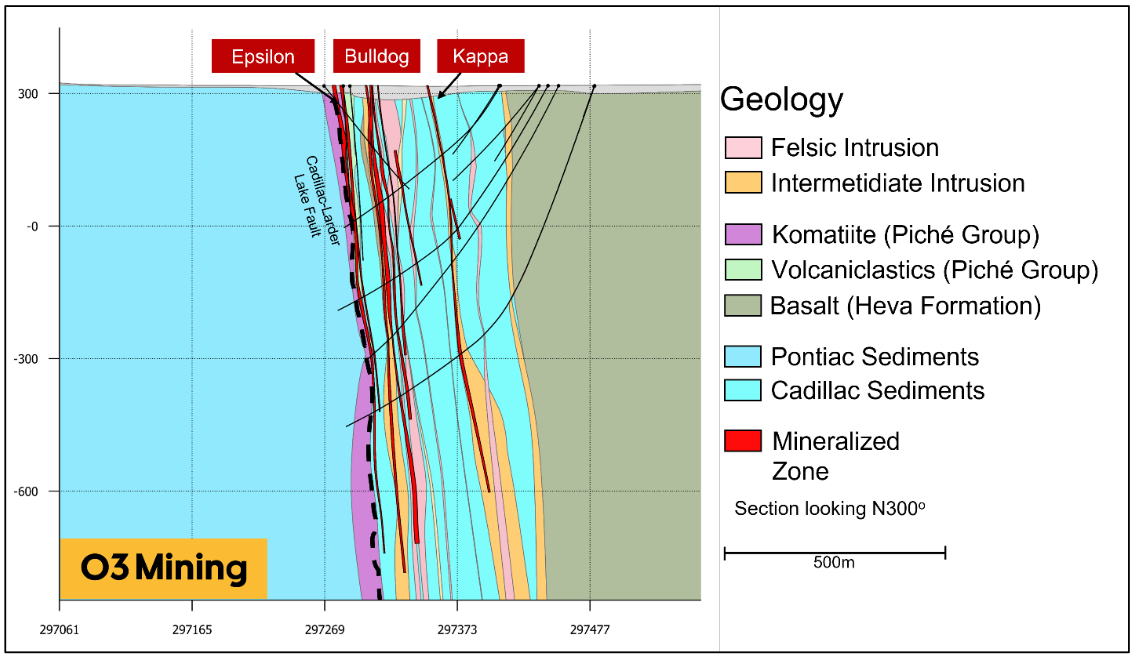
Local geology:
For a description, see the Bulldog deposit section.
Deposit geology:
The Kappa deposit is a skarn-related deposit hosted primarily with a porphyritic diorite intrusion, emplaced into the greywacke-argillite sequence of the Cadillac sediments approximately 200 m to the north of the Cadillac-Larder Lake Shear Zone. Mineralization is divided into three gold zones, two zones located near the contacts of the intrusion with the hanging wall and the footwall respectively, and a third zone towards the middle of the dyke. Gold mineralisation is present in both the dyke and in the surrounding sediments. Presently, two elevated gold-sectors or ore shoots have been intercepted, one at around 60 meters true vertical depth and another 500 meters further to the east beginning at around 560 meters true vertical depth.
The intrusion and related mineralization zones dip steeply to the north-northeast at around 80 degrees. The intrusion increases in thickness with depth. At shallower depths, the intrusion is only a couple meters -thick, while at depth the intrusion widens to over 50 meters in thickness. Smaller, unmineralized splays are also often encounter nearby to the north of the deposit. The intrusion is weakly to moderately sheared, with a fabric sub-parallel to the intrusion. Deformation is generally higher near the contacts of the intrusion.
The intrusion is strongly altered by biotite, calcite, and epidote, with the latter showing strong heterogeneity in intensity. Biotite alteration extends into the surrounding sediments, and a strong alteration halo is observed for tens of meters outside of the principal zone. Albitization of the sediments at the contacts is also observed and is associated with an increase in sulphide stringers.
The intrusion contains multiple generations of pyrite-chalcopyrite bearing veins with a quartz-calcite-epidote-chlorite-tourmaline gangue, but gold mineralization is predominately constrained to centimeter-thick quartz-calcite-epidote-chlorite veins. This generation of veins show moderate deformation and folding and are intercepted with two main orientations: parallel to the sheared contacts of the dyke and moderately south dipping. A positive correlation is observed between the amount of chalcopyrite in the veins and the corresponding gold values. Clusters of pyrite and chalcopyrite are also found dispersed throughout the dyke, though do not appear to be strongly related to gold mineralization. In the surrounding Cadillac sediments, gold is associated with pyrite-chalcopyrite-pyrrhotite-sphalerite stringers hosted in the selvages of bedding-parallel quartz veinlets. Visible native gold is occasionally observed as gold-pyrite-epidote clusters and as individual grains in the quartz-calcite-epidote-chlorite veins. There is an anomalous silver-copper-zinc signature observed in all three zones.
Ore specimens:

Typical Style of Mineralization at Kappa
Note:
Notes for mineral resources for the effective date 2022-11-10:
Underground Mineral Resources have been reported using a 1.8 g/t lower cut-off.
The Bulldog deposit has been classified as Inferred Mineral Resources according to drilling spacing and estimation pass. No Measured or Indicated Resources have been estimated. Underground Mineral Resources have been categorized manually to remove isolated areas not satisfying Reasonable Prospects of Eventual Economic Extraction (RPEEE) and have been reported using a 2 m minimum thickness.
The tonnages have been rounded to the nearest 1,000 tonnes and the metal content has been rounded to the nearest 1,000 ounces. Gold grades have been reported to one decimal place reflecting the uncertainty associated with Inferred Mineral Resources.
Notes from goldmap.info: the calculation of metric gold resources is conducted by multiplying the ore tonnage by the grade.
Mineral Resources (Nov. 10, 2022)
| Class | Ore (ktonnes) | Au grade (g/t) | Au (kg) | Au (oz * 1000) |
|---|---|---|---|---|
| Inferred | 403.00 | 3.70 | 1491.10 | 318.00 |
Source:
-
NI 43-101 Technical Report Alpha Property Québec, Canada
(23.12.2022, Brossard)
Authors: Purchase James