Detour Lake
Phase: Operations
Mine Type: Pit
Tags: actinolite amphibolite argillite biotite breccia chalcopyrite chert chlorite diabase dyke gabbro gneiss green schists greenstone belt greywacke mylonite pyrrhotite silicification stockwork talc tonalit tourmaline tremolite visible gold
Canada, Ontario. From the town of Cochrane (population of approximately 5,000 residents), the Project is easily accessible by the Detour Lake Mine road, the northern extension of Highway 652. The first 151 km on Highway 652 is paved surface, followed by 34 km of well-maintained chipseal road to the mine site. Road access is available year-round. An airstrip built in 2021 provides access by air to the site. The closest major airport to the site is at Timmins, Ontario, approximately 61 km to the southeast.
Site topography is subdued with maximum local relief of approximately 30 m. The elevation ranges from approximately 260–288 metres above sea level. There is a pronounced north/south fluting of the landscape consistent with the general direction of the most recent glaciation in this area.
Areas of higher relief are sparsely wooded with jack pine, black and white spruce, balsam fir, trembling aspen, and white birch. Areas that are slightly lower in relief are poorly drained
and characterized by muskeg.
There is very little bedrock outcrop and much of the Project area is overlain by thick accumulations of glacial material that includes till and glaciofluvial material (poorly sorted sand with lenses of gravel).
Numerous small streams linking elliptical lakes and ponds, generally oriented parallel to the pattern of glacial fluting. Numerous small and shallow lakes are found within the Project
area, the largest being Sunday Lake, with a surface area of approximately 2.8 km2.
History:
1974 - 1979. Amoco Canada Petroleum Company Ltd. (Amoco). Completed regional airborne geophysical surveys, ground Crone electromagnetic, RADEM and magnetometer surveys, drilling (335 core holes for 57,339 m in Mine Property area, 6 core holes for 986 m in Block A), decline construction, construction of a winter road, Mineral Resource estimate, and completion of a feasibility study in the Mine Property area. The feasibility study results were not encouraging and the property was offered for joint venture.
1978. Amoco, Campbell Red Lake Mines (Campbell) and Dome Mines Ltd. (Dome). Joint venture (JV) agreement signed.
1979 - 1987. Campbell and Dome. Completed channel and rock chip sampling, surface and underground drilling, Mineral resource, and mineral reserve estimates in the Mine Property area. Open pit mining commenced in 1983 and was completed in 1987.
1983 - 1984. Global Energy Corporation. Option from Ingamar Exploration Ltd on Block A. Completed 15 drill holes. Narrow gold intersections returned from several closely spaced holes approximately 400 m north of Lindbergh Lake.
1987 - 1999. Placer Dome Inc. (Placer Dome). Merger between Campbell, Dome, and Placer Development to form Placer Dome. Acquired Amoco’s 50% property interest in 1988. Open pit mining briefly recommenced in 1998. Underground mining at Detour Lake commenced in 1987 and ran to 1999. Due to a combination of low metal prices and production and
grade problems all mining ceased in 1999, and reclamation activities were initiated. Drilling in the period 1987–1998 consisted of 4,219 surface and underground holes (435,002 m). Placer Dome completed an additional 90,889 m in 283 core holes for exploration purposes on the Mine Property and 62,147 m in 133 holes in outlying areas.
1998. Pelangio–Larder Mines Limited (Pelangio–Larder) and Franco–Nevada Mining Company Limited (Franco–Nevada). Formed the Detour Lake JV. Acquired the Mine Property from Placer Dome. Also acquired certain parts of the Detour Exploration Lands surrounding the Mine Property.
During the initial 17-year mine life from 1983–1999, production is estimated at 1.7 Moz Au from about 14.3 Mt grading 3.82 g/t Au, with mill recovery averaging 93.1%.
2000. Marl Resources Corp. (Marl Resources). Marl Resources acquired the majority of Pelangio–Larder’s assets, including the Pelangio-Larder interest in the Detour Lake JV. Franco–Nevada interest passes to Newmont Mining Corporation of Canada Limited (Newmont).
2000 - 2002. Pelangio Mines Inc (Pelangio). Marl Resources changes name to Pelangio. Completed the purchase Newmont’s interest in the Detour Lake JV. Newmont retains 2% NSR; Newmont subsequently transferred NSR to Franco–Nevada.
2003. High River Gold Mines Ltd. Pelangio and High River Gold Mines formed a strategic alliance whereby High River acquired 19% of Pelangio shares and provided technical expertise and operations management to Palangio.
2003 - 2011. Trade Winds Ventures Inc. (Trade Winds). Completed core holes (134,000) m in the Block A and Gowest properties. Drilling of 109,718 m in 329 holes at Detour West. Mineral resource estimate for West Detour deposit.
2004 - 2006. Pelangio. Completed drilling consisting of 127 core holes (29,769 m) and a Mineral Resource estimate assuming a combined underground and open pit operation.
2006 - 2019. Detour Gold. Purchase agreement with Pelangio in 2007 to acquire all Detour Lake assets, including Block A. Acquired Goldcorp Canada Ltd. (Goldcorp; successor to
Placer Dome) interest in Mine Property in 2008. Concluded JV agreement with Trade Winds in 2009. Acquired Aurora property from Conquest Resources in 2010. Acquired Trade Winds and thereby a 100% interest in the Block A and Gowest properties. Purchased Goldcorp 1% NSR on the Mine Property for $1 million in 2012. Obtained 100% interest in Sunday Lake Property in 2014.
Completed geological mapping, mobile metal ion (MMI), bedrock grab and channel geochemical surveys, an amplified geochemical imaging soil gas survey, age dating, airborne geophysical surveys, ground induced polarization (IP), infill drilling (541,087 m in 1,395 core holes at Detour Lake; 49,158 m in 156 core holes at West Detour), geotechnical, metallurgical and condemnation drilling, Mineral Resource and Mineral Reserve estimates, pre-feasibility and feasibility studies assuming open pit mining.
Mine construction commenced in 2012, and commercial production was declared in 2013. Exploration core drilling included 12,054 m in 38 holes peripheral to the Detour Lake Mine in 2008; 5,025 m in 22 holes targeting the vicinity of Detour Lake Mine, the Sunday Lake Property and LDDZ (in the Lower Detour area) during 2011; 5,061 m in 17 holes targeting the Lower Detour area in 2012; 26,765 m in 80 holes targeting the Lower Detour area and Sunday Lake Property in 2013; 14,874 m in 40 holes targeting the Lower Detour area in 2014; 36,577 m in 72 holes targeting Zone 58N in the Lower Detour area in 2015; 52,079 m in 168 holes targeting Zone 58N and 17,434 m in 59 holes in Lower Detour and tailings management areas (TMA), and Massicotte claims during 2016, 35,212 m in 99 holes targeting Zone 58N and 1,155 m in 3 holes in TMA area during 2017. During 2019, Detour gold completed 41 core drill holes within the Lower Detour Property totalling 13,651 m.
Production during the Detour Gold ownership period (2013–30 January 2020) is estimated at 3.6 Moz Au from about 135.5 Mt grading 0.90 g/t Au, with mill recovery averaging 90.1%.
2020 - 2022. Kirkland Lake Gold. Effective 31 January, 2020, Kirkland Lake Gold completed the acquisition of Detour Gold, and Detour Gold became a wholly-owned subsidiary of Kirkland Lake Gold. Effective 2 January, 2021, Detour Gold was amalgamated with Kirkland Lake Gold Inc., a wholly-owned subsidiary of Kirkland Lake Gold and the amalgamated entity was renamed Kirkland Lake Gold Inc. The Project became wholly-owned by Kirkland Lake Gold Inc., a subsidiary of Kirkland Lake Gold.
During the acquisition period of Detour Gold by Kirkland Lake Gold, 11 holes were drilled at 58N totaling 3,693 m. Kirkland Lake Gold commenced a large surface core program to look for mineralization extensions that could potentially support Mineral Resource estimation or upgrades to confidence categories, with 78 core holes with 6 wedge holes totalling 66,115 m drilled in 2020.
Production from 31 January, 2020 to 31 December, 2020: ore milled 21.1 Mt, grade 0.83 g/t, recovery 91.3%, gold 516.8 koz.
Updated Mineral Resource estimates 26 July, 2021; completed 247 core holes for 176,825.9 m of drilling.
Collected and submitted 27,738 samples from 2020–2021 core holes drilled in the West Detour area for geochemical (ICP) analysis. In 2021 completed 315 holes core holes for 252,001 m of drilling. Effective 4 February, 2022, Kirkland Lake Gold Inc. amalgamated with two affiliates, Kirkland Lake Gold and Crocodile Gold Inc., and the resulting legal entity
was continued as “Kirkland Lake Gold Ltd.”.
Production from 1 January, 2021 to 31 December, 2021: ore milled 24.1 Mt, grade 1.00 g/t, recovery 91.7%, gold 713 koz.
Updated Mineral Resource estimates Feb 5, 2022; from and additional 121 core holes and 18 extended holes for 105,558 m of drilling.
2022 - 2024. Agnico Eagle. Effective 8 February, 2022, all the shares of Kirkland Lake Gold were acquired by Agnico Eagle and accordingly, Kirkland Lake Gold became a wholly-owned Agnico Eagle subsidiary.
In 2022, completed 203 core holes for 234,049 m of drilling including nine metallurgical holes. Collected and submitted 9,682 samples from 2022 core holes drilled for geochemical (ICP) analysis.
Production from 1 January, 2022 to 31 December, 2022: ore milled 25.5 Mt, grade 0.97 g/t, recovery 92%, gold 732,6 koz. 2022 production is a combination of ounces produced by Kirkland Lake Gold from 1 January–7 February 2022 with the remainder of the year’s ounces from 8 February to 31 December produced by Agnico Eagle.
In 2023, completed 213 core holes for 217,792 m of drilling including five geotechnical holes. Collected and submitted 12,646 samples from 2023 core holes drilled for geochemical (ICP) analysis.
Production from 1 January, 2023 to 31 December, 2023: ore milled 25.4 Mt, grade 0.91 g/t, recovery 90,9%, gold 677,4 koz.
Effective January 1, 2024, Kirkland Lake Gold and Agnico Eagle amalgamated with the resulting entity continuing as Agnico Eagle. From 1 January to 31 March, 2024, 42 core holes for 58,001 m of drilling completed. Collected and submitted 401 samples from 2024 core holes drilled for geochemical (ICP) analysis.
Regional geology:
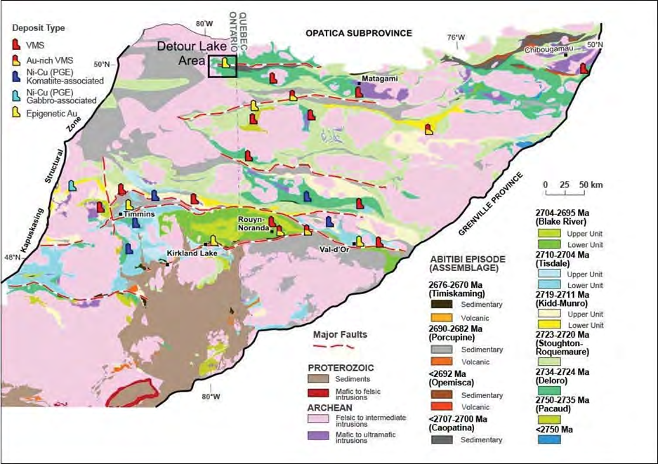
Abitibi greenstone belt
Abitibi greenstone belt of the Superior province of the Canadian Shield. The area consists mostly of felsic to mafic volcanic rocks of Archean age together with related dioritic sills which are concordant to the regional rock formations. These volcanic and intrusive rocks have generally been metamorphosed to the greenschist facies.
The Superior Province is the largest exposed Archean craton in the world and hosts several world class gold deposits. It has yielded nearly 300 million ounces of gold from hundreds of deposits since the beginning of the twentieth century. One prominent characteristic of all significant gold deposits in the Superior Province is their occurrence within or immediately adjacent to greenstone belts. Another characteristic is their occurrence within major tectonic zones which comprise a series of shear zones (Colvine et al., 1988). The Superior Province is divided into four major subprovince types (Card and Ciesielski, 1986): volcano-plutonic, plutonic, metasedimentary, and high metamorphic grade gneiss. The boundaries of these subprovinces are either major dextral, transcurrent, east-striking faults, or zones of structural and metamorphic transition.
The greenstone belts which host the gold deposits occur as east-north-easterly trending ribbon domains in the volcano-plutonic terrains. They typically consist of mafic to ultramafic and felsic metavolcanic rocks, interlayered with metasedimentary rocks. The supracrustal rocks were intruded by syn-volcanic plutons. Saturated and under saturated felsic to mafic igneous rocks intruded into the greenstone belts in late Archean.
The metamorphic grade of most of the present greenstone terrains ranges from sub-greenschist to greenschist facies in the centre, to lower amphibolite facies at the margin. Amphibolite facies contact metamorphic aureoles occur around intrusions into the greenstones (Jolly 1978, 1980) with the exception of the synvolcanic ones.
The Abitibi Greenstone Belt consists of east–west-trending synclines of felsic to ultramafic volcanic rocks. Intervening domes are cored by syn-volcanic tonalite and gabbro-diorite rocks and alternate with east–west-trending bands of late tectonic turbiditic and conglomeratic sedimentary rocks. Most of the volcanic and sedimentary strata dip vertically and are commonly bound by abrupt, east–west-trending faults with varied dips.
The stratigraphy of the Abitibi Greenstone Belt is subdivided into earlier volcanic-dominated episodes that include the Pacaud assemblage (2770–2736 Ma), the Deloro assemblage (2730–2724 Ma), the Stoughton-Roquemaure assemblage (2723–2720 Ma), the Kidd- Munro assemblage (2719–2711 Ma), the Tisdale assemblage (2710–2704 Ma), and the Blake River assemblage (2704–2695 Ma). These sequences are unconformably overlain by turbidites and calc-alkaline volcanic rocks of the Caopatina assemblage (ca. 2700 Ma) in the north and the Porcupine assemblage (2690–2685 Ma) in the south. These units in turn are unconformably overlain by coarse clastic and alkaline volcanic rocks of the Opemisca assemblage (ca. 2692 Ma) in the north and the Timiskaming assemblage (2676– 2670 Ma) in the south.
Berger (2002):
The Kidd-Munro assemblage underlies the north part of the study area and is composed of a tholeiitic metavolcanic member and a calc-alkalic metavolcanic member. Ultramafic to mafic layered sills intrude the metavolcanic rocks.
The Tisdale assemblage is composed of tholeiitic metavolcanic rocks and subordinate amounts of calc-alkalic metavolcanic rocks. The distribution of the assemblage is poorly constrained because of the Porcupine-Destor deformation zone and related splay faults transect the assemblage in several places.
The Kinojevis assemblage underlies the south part of the study area and is composed of predominantly mafic tholeiitic metavolcanic rocks that are intercalated with thin units of tholeiitic rhyolite and calcalkalic metavolcanic rocks.
The Porcupine assemblage underlies the northwest part of the study area and is composed of greywacke, argillite, and rare conglomerate that are intruded by small alkalic intrusions.
The Timiskaming assemblage is composed of clastic and chemical metasedimentary rocks and rare alkalic metavolcanic rocks that are distributed within and near to the Porcupine-Destor deformation zone. Ultramafic to felsic alkalic intrusive rocks are also correlated with the Timiskaming assemblage and occur as dikes, small single-phase intrusions and large multi-phase intrusions throughout the area. Paleoproterozoic quartz-diabase dikes, Keweenawan-age olivine diabase dikes and Jurassic kimberlite dikes and diatremes intrude the Neoarchean rocks.
The Porcupine-Destor deformation zone is a crustal-scale structure that transects the study area and is characterized by south-side-up vertical movement. The fault zone and related
northeast-striking splay faults such as the Ghostmount fault and McKenna fault, are the loci for gold mineralization. Northeast-striking faults with dominant vertical displacement transect the Porcupine-Destor deformation zone. Two of these faults, the Hislop fault and Garrison fault, are major structural features that act as the boundaries to different metallogenic segments. Gold mineralization occurs in different structural settings, different styles, and different types of alteration patterns in each segment.”
Local geology:
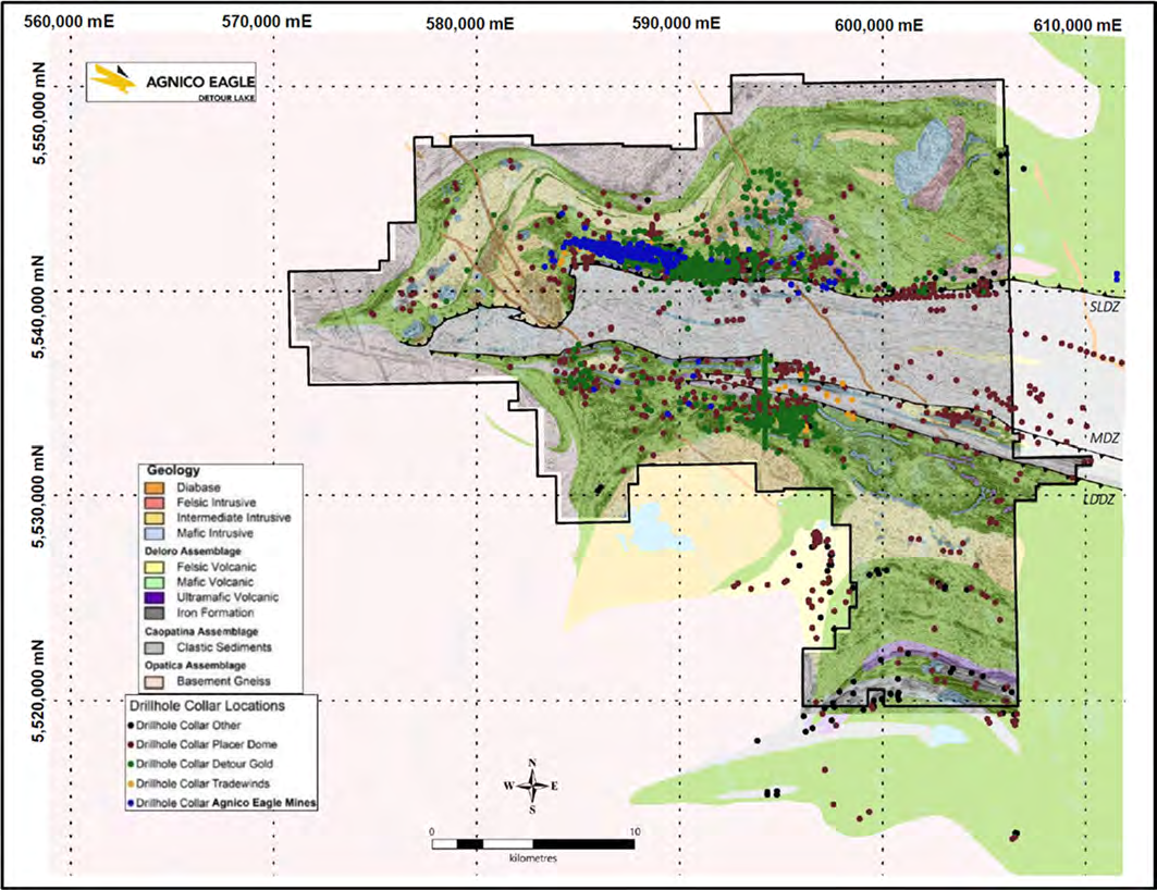
In the Project area, the greenstone–granite architecture is partially aligned and disrupted along a linear, east–west-trending belt that defines the position of the Sunday Lake Deformation Zone.
Supracrustal rocks within the Project area consist of a thick sequence of mafic to ultramafic lithologies, which are predominantly volcanic in origin, and are part of the Deloro assemblage. They occur within regional synclinal-anticlinal fold structures traced for over 30 km across the Project and are in structural contact to the south with the younger
sediments of the Caopatina assemblage. These rocks are bounded to the north and west by the Opatica basement gneissic rocks. To the east and south, the Deloro assemblage is intruded by several large, weakly foliated granodioritic to tonalitic intrusions which are intersected by numerous local felsic to mafic dykes, sills, and younger regional Proterozoic diabase dykes.
Lithologies:
- Tonalitic to granodiorite intrusions. Weakly foliated and distinctly tonalitic in composition. The intrusion shifts to a more granodioritic composition within 300 m of its contact.
- Felsic to mafic dykes. The dykes can have a variety of colours and textures ranging from light to dark coloured and aphanitic to feldspar porphyritic. Intermediate dykes are less common and are predominantly fine-grained and locally porphyritic. Most dykes have east-west trends, parallel to sub-parallel to the main foliation. Intrude all earlier units.
- Caopatina assemblage. Poorly to well laminated metasedimentary unit (argillites, greywackes, and quartz wackes) and mafic volcaniclastics.
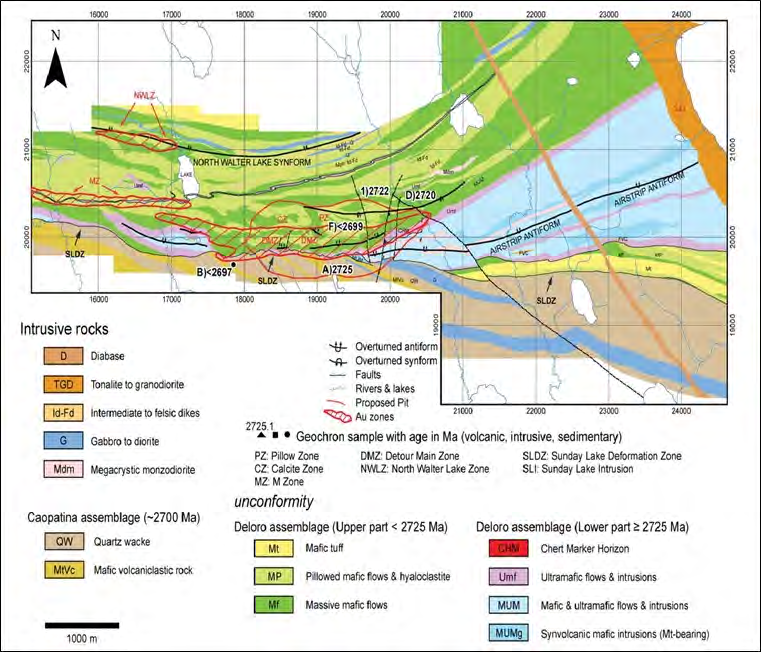
- Upper Detour Lake Formation.
4.1. Chloritic greenstone. Mafic to ultramafic komatiitic volcanic rocks, strongly altered to chlorite or talc–chlorite schist.
4.2. Amphibolite dykes (flow). Lower strain mafic dykes or flows, concordant with the stratigraphy. The amphibolite units generally occur at the base of the first two pillow flow sequences north of the Sunday Lake Deformation Zone and show less pervasive mineralization and alteration than the adjacent flows.
4.3. Massive flows. Grey; fine to medium grained with local porphyritic texture; weak to moderately foliated. Pillow-structure, hyaloclastite and vesicles filled by calcite may be present locally. Several very massive magnesium-rich tholeiitic flow sequences are present in the hanging wall sequence of the Detour Lake Mine and West Detour deposit.
4.4. Pillow flows. Fine to medium-grained; usually shows foliation. Characterized by pillow selvages, the formation of hyaloclastite, and vesicles filled by calcite. Common throughout the Detour Lake Mine and West Detour areas. - Lower Detour Lake Formation.
5.1. Mafic sills and dykes. Abundant mafic (gabbroic) intrusions, finer- grained flows, and dykes. Mafic intrusions may be strongly magnetic.
5.2. Megacrystic diorite. Sill.
5.3. Mafic volcanic. Dense green–black flow unit. Lies to the south of the talc– chlorite alteration zone of the Detour Lake Mine.
5.4. Ultramafic flows and sills. Thick sequence of ultramafic flows, with locally-preserved spinifex textures, coarse- grained pyroxenites, and fine-grained ultramafic sills. Conformable contact relations with the other volcanic units. Not observed in the West Detour deposit.
5.5. Mafic flow contact unit (chloritic schist). 5–20 m-thick flow unit, fine grained, light to dark greenish black; commonly overlies ultramafic rocks. Is present on both the footwall and hanging wall sides of the chert marker horizon.
5.6. Chert marker horizon. Thin (0.5–2.0 m thick), cream to buff, locally laminated, and commonly strongly sulphidized felsic rock. May represent deformed tuffaceous or volcaniclastic rocks, which mark the transition from ultramafic- to mafic-dominated volcanism in the Detour Lake Formation. Not observed in the West Detour deposit.
The Deloro Assemblage, north of the Sunday Lake Deformation Zone, is sub-divided into the Upper Detour Lake Formation, a volcanic assemblage dominated by tholeiitic basalt
(mainly high-Mg massive and high-Fe pillowed flows); and the Lower Detour Lake Formation, an ultramafic-dominant komatiitic and high-Mg tholeiitic volcanic and intrusive
assemblage.
Where the komatiitic lithologies are in contact with the Sunday Lake Deformation Zone, they are highly deformed and altered into talc–chlorite schist. The contact is highly mylonitized, mineralized and silicified and hosts a strongly deformed felsic to intermediate dyke-like body known locally as the “chert marker horizon”.
The chert marker horizon is not a chert unit, but rather a fine-grained felsic volcaniclastic unit and/or a series of intensely silicified and sulphidized volcanic rocks and intermediate sills and dykes. It occurs between mafic-dominated volcanic rocks of the Upper Detour Formation (hosts hanging wall mineralization) and ultramafic volcanic rocks of the Lower Detour Formation (hosts footwall mineralization).
Structure:
The major structural feature is the 30 km-long Sunday Lake Deformation Zone, an east–west-trending, steeply north-dipping deformation corridor. The zone marks the northern contact between the Caopatina assemblage sedimentary rocks and the underlying Deloro assemblage volcanic rocks. Mineralization at Detour Lake and West Detour is spatially related to Sunday Lake Deformation Zone structures.
Kinematic indicators confirm sinistral–reverse north over south motion along the Sunday Lake Deformation Zone. A regional east–west trending structure, the Massicotte Deformation Zone is recognized several kilometres to the south of the Sunday Lake Deformation Zone and extends for over 30 km in strike length. It marks the southern contact between the Caopatina assemblage sedimentary rocks and the underlying Deloro assemblage volcanic rocks.
The third major structure is the Lower Detour Deformation Zone, a 30 km long, east–west-trending, and steeply south-dipping one that separates Caopatina assemblage sedimentary
rocks and the underlying Deloro assemblage volcanic rocks. Zone 58N occurs immediately south of the Lower Detour Deformation Zone.
The youngest structures are a series of 120–145° trending faults, which are locally intruded by Proterozoic-age diabase dykes.
Two east-trending synform–antiform pairs are developed in the volcanic assemblage, the North Walter Lake Synform and the Airstrip Antiform. These folds are tight, upright, slightly overturned, and south-facing. A later fold set consists of broad open folds that have axial traces striking at approximately 145°,and plunging 10–35° to the northwest. The inter-limb distances of these folds are approximately 8–12 km.
Metamorphism:
All rock units have undergone upper greenschist to lower-grade amphibolite metamorphism.
Alteration:
All lithological units are hydrothermally altered proximal to major deformation zones. Strong secondary biotite is developed in mafic rocks. Talc–actinolite chlorite assemblages formed in ultramafic sills next to the chert marker horizon and across the northern edge of the Detour Lake deposit and through the West Detour deposit. The footwall magnesium-rich komatiitic volcanic rocks show alteration to schistose rocks with a mineral assemblage of chlorite–talc–calcite–tremolite/actinolite–biotite. Silicification may overprint the biotite alteration or occur as an intense pinkish halo with associated potassic feldspar flooding.
Mineralization:
There are two recognized episodes of gold mineralization at the Detour Lake and West Detour deposits.
The first episode consists of a wide and generally auriferous sulphide-poor quartz vein stockwork formed in the hanging wall of the Sunday Lake Deformation Zone. The sulphide-poor quartz vein stockworks observed in the hanging wall have sub-vertical north or south dips and are parallel to a series of east-west trending high strain zones. These veins form
a weak stockwork and are boudinaged and/or folded.
The second episode is a stage of gold mineralization overprinting the early auriferous stockwork, principally in the hanging wall of the Sunday Lake Deformation Zone, with a higher sulphide content. The sulphide-rich gold mineralization predominantly fills structural sites in deformed quartz veins, fractures and veins crosscutting the foliation fabric but also in pillow breccias and selvages. The distribution of sulphide-rich mineralization is strongly controlled by the geometry of kinematic orientation (i.e., pyrite and pyrrhotite concentrations have a shallow westerly plunge similar to the plunge of the main flexure zone in the Sunday Lake Deformation Zone at an angle of about 40° (in the area of the former Campbell pit), shallowing to approximately 10° further to the west).
Deposit geology:
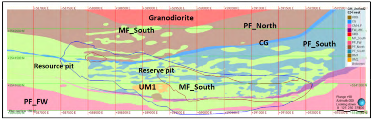
The Detour Lake deposit and the West-North Detour deposit, are a single mineral deposit.
Mineralization at Detour Lake is hosted within a broad corridor. Mineralization extends from approximately 584,000 E to 593,000 E, 5,540,500 N to 5,542,000 N and 5,500 m elevation
to 6,300 m elevation. This corresponds to a strike extent of 9.0 km, a width of 1.5 km, and an approximate elevation range of 1,000 m.
Lithologies:
Mineralization is hosted within a broad assemblage of mafic volcanic rocks with an overall east–west trend. The deposit has been drill tested along this mineralized corridor for a distance of over 10 km. The bulk of the mineralization within this corridor is concentrated along a highly-strained corridor of a moderate to strong potassic alteration envelope at the
contacts between pillowed and massive mafic flows.
Located at the eastern end of this corridor, within the active Detour Lake open pit, is the Main Zone. The Main Zone was the largest gold-bearing mineralized zone exploited in the period from 1983–1997, and consists of gold mineralization occurring in the Chert Marker Horizon or in quartz and quartz–carbonate vein systems splaying from the Sunday Lake Deformation Zone. Historical quartz zones Q50, Q70, Q100 and Q120 were typical quartz vein arrays splaying off the Sunday Lake Deformation Zone into the hanging wall.
The former Campbell open pit was located at the shallowest zone developed along the contact between massive magnesium-rich tholeiitic and pillowed iron-rich tholeiitic volcanic rocks.
West of section 19,620E, the mineralization mainly straddles the lower massive flow-pillow flow contact and is commonly associated with increased biotite alteration. Mineralization is generally well distributed within this sequence but lithological changes to coarser and massive facies may locally affect mineralization continuity.
From sections 16,160E to 17,160E, Placer Dome intersected the QK Zone along a massive flow–pillow flow contact between 600–750 m below surface.
The Main Zone mineralization, the focus of previous underground mining, strikes easterly to northeasterly, and has an average dip of 70º N. It has a plunge of 40º W near surface, flattening out below the 660 m level. The hanging wall contact is irregular, resulting from diverging quartz vein structures. The footwall contact is more regular and undulates with local dips varying from 300 to near vertical. The Quartz Hanging Wall Zones strike at azimuth 080º, with a vertical to near vertical dip, and a plunge of 45º W parallel to the Main Zone.
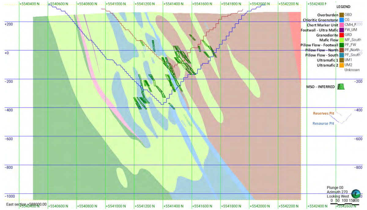
During previous underground development down to the 825 m level, the Main Zone had average dips of 70º N. The Quartz Hanging Wall zones, also the subject of historical underground mining, are characterized by discrete groups of steeply-dipping (predominately north) quartz veins. Generally having widths of 3–5 m, these quartz zones appear to splay off the Chert Marker Horizon, although it is difficult to trace these zones directly back to the chert. Potassic alteration is locally associated with these zones.
The mineralization hosted in the Main and Quartz Hanging Wall Zones was tested by underground core drilling to a vertical depth of 900 m from surface and approximately 100 m
below historical mine workings. The results from this drilling demonstrate that there may be potential to extend this mineralization at depth.
The footwall Talc Zone is principally located between 590,500 E and 592,000 E (eastern end of the Detour Lake Mine). It is hosted in highly altered (i.e., serpentinized and talcose) ultramafic flows with mineralization concentrated at both the upper contact (Chert Marker Horizon), and lower contact of the Sunday Lake Deformation Zone, next to barren volcaniclastics and mafic volcanic rocks. Locally, the mineralization is cut by felsic to intermediate intrusive dykes, ranging in width from 0.3–25 m. The footwall mineralization commonly contains boudins of quartz veins and felsic as well as intermediate dyke slivers. It is generally intensely sheared, especially in the area adjacent to the contact with the volcaniclastic sediments.
To the west, mineralization associated with gold zones occurs in a variety of structural settings and several rock types including massive to pillowed tholeiitic basalt flows, variably deformed-altered basaltic to peridotitic komatiite units, cherty tuffs, gabbro and deformed felsic to intermediate dykes. Larger gold zones are subparallel to concordant with
stratigraphy (contact related) and smaller quartz and potassic veins occur along splays.
Mineralization is commonly associated with increased biotite alteration, shearing, narrow quartz veining and minor pyrite or pyrrhotite. Local zones of strong brecciation with sulphide infilling were recognized, together with minor chalcopyrite, telluride minerals and visible gold. Gold mineralization is associated with a series of sub-vertical to arcuate deformation zones characterized by enhanced strained fabrics, well-defined open-space breccias, and to a lesser degree sheeted shear-hosted veins and extensional veins.
Located in the hanging wall and analogous with Placer Dome’s “M-Zone” lies an amphibole-chlorite rich ultramafic sheared structure termed chloritic greenstone (CG). Considered to
be a key marker horizon, the unit can be traced across the entire deposit. In the western portion of the Detour Lake deposit, the chloritic greenstone is an important mineralized structure containing or juxtaposed to increased gold mineralization. The unit can be quite variable both structurally and mineralogically. It is often observed as a strongly deformed ultramafic comprised predominantly of amphibole and chlorite, contains no apparent primary textures, and can be strongly foliated, folded, jointed, locally crenulated, or even massive. Locally it is strongly biotite-altered and can be intercalated with felsic–intermediate intrusions and locally faulted. It often contains highly dismembered quartz veins both within it and along the contacts with intercalated altered felsic to intermediate intrusions. Additional chloritic greenstone units have been noted above and below the mineralized chloritic greenstone in the hanging wall, though these appear to more discontinuous and are typically intercalated with the surrounding mafic volcanic units.
In addition to being located in the hanging wall there is also at least one laterally continuous chloritic greenstone unit close to the Sunday Lake Deformation Zone, often occurring stratigraphically between the ‘chert’, and the footwall metasedimentary rocks. This footwall chloritic greenstone unit appears to be laterally equivalent to the eastern talc chlorite schist of the former underground mine and has been observed to be intercalated with the footwall metasedimentary units.
Approximately 200 m north of the chloritic greenstone unit, mineralization along the North Walter Lake Trend is developed in a zone of high strain with deformed quartz veins within
pillowed to massive mafic volcanic flows. It is hosted by a komatiitic tholeiite mafic volcanic unit and flanked by iron-tholeiitic mafic rocks in the hanging wall and magnesium-tholeiitic mafic rocks in the footwall.
Mineralization:
Seven dominant mineralized domains containing most of the high-grade mineralization at the Detour Lake deposit have been defined and characterized Gold is associated with quartz–carbonate–pyrite–pyrrhotite ± tourmaline veins and/or disseminated to very local semi-massive sulphides in hydrothermally-altered wall rocks.
Domain 51 is spatially associated with the Chert Marker Horizon known as the Main Zone. The Main Zone was the largest gold-bearing mineralized zone initially mined underground during the 1983–1987 period, exploiting a northeast to east–northeast-trending contact area between tholeiitic mafic volcanic rocks to the northwest, and ultramafic–komatiitic mafic rocks to the southeast. The mineralized zone consists of gold mineralization occurring along the Chert Marker Horizon in quartz and quartz–carbonate vein systems splaying from the Sunday Lake Deformation Zone.
In the East end of the Detour deposit and coincident with the Chert Marker Horizon, various talc zones occur along the footwall. With widths from 4–15 m, the talc–chlorite mineralization tends to be less continuous along strike than mineralization along the hanging wall side of the Chert Marker Horizon. Gold in the Talc Zone is dominantly associated with pyrite, pyrrhotite, and minor chalcopyrite along foliation planes, narrow discrete shears, or strain zones, and in irregular lenses. The talc zones also contain short, deformed lenses or boudinaged quartz veins. In some cases, mineralization is controlled by well-developed fault structures containing several centimetres of gouge material.
Domain 52 is associated with hanging wall mineralization occurring in several different rock units within broad sub-vertical mineralized envelopes, which may split into several sub-vertical domains sub-parallel to the Sunday Lake Deformation Zone.
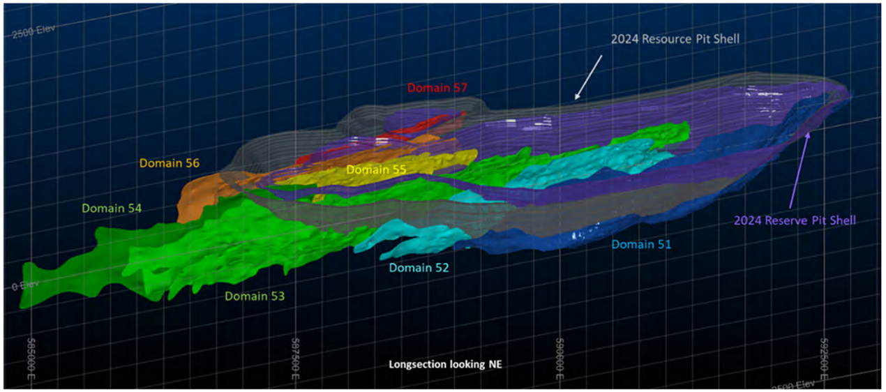
The main underground vein corridors mined historically consisted of the Q zones (Q50-Q120), which splay off the northwestern side of the Chert Marker Horizon, and comprise steeply-dipping, parallel cm-to-tens-of-cm-wide quartz-sulphide veins, and veinlets in sheeted zones locally >10 m wide. Mineralization is commonly associated with increased biotite alteration, shearing, narrow quartz veining and minor pyrite or pyrrhotite. Local zones of strong brecciation with sulphide infilling have also been recognized, along with minor chalcopyrite, telluride minerals and visible gold. Gold mineralization is associated with a series of sub-vertical to arcuate deformation zones characterized by enhanced strained fabrics, well-defined open-space breccias, and to a lesser degree sheeted shear-hosted veins and extensional veins.
Further to the west lies the “QK Zone” as denoted by Placer Dome. This mineralization is associated with narrow parallel to sub-parallel quartz veins, quartz boudins and sulphide-rich veins/breccias with adjacent silicification and potassic alteration envelopes.
Further to the north and hanging wall to the Q-zones, Domain 53 is spatially associated with highly-strained corridors at the contacts between pillowed and massive mafic flows encompassing higher grade mineralized zones. These broad zones contain variable amounts of quartz and pyrite, and are controlled mainly by east-west trending, moderately north-dipping folds and shear structures which plunge at a shallow angle to the west.
Identified as “M Zone” by Placer Dome, Domain 55 encompasses high-grade areas towards the west end of the deposit, mostly following the west extension of the chloritic greenstone unit. Spatially, Domain 55 lies approximately 400–500 m north of the Chert Marker Horizon and is a westerly-trending gold system that is spatially associated with the margins of the chloritic greenstone unit.
Domain 54 is located west of Domain 55 and appears separated by a steeply dipping west–northwest to east–southeast-oriented brittle fault system interpreted to have potentially 100–150 m of offset. Investigations are currently underway to substantiate and further investigate the brittle structure. Both of these amphibole–chlorite schist stratigraphic horizons and associated gold mineralization were traced by drilling for approximately 5 km. The footwall and hanging wall sequence of the chlorite schist is variably biotite altered with abundant fractures, with a well-defined foliation which contains local quartz veining with associated pyrite, pyrrhotite and rarely, chalcopyrite. The mineralized zones appear lensoidal and plunge 20° west. Mineralized lenses vary from 5–50 m in true width.
Domain 56 has similar characteristics to Domain 53, encompassing high-grade mineralized zones within partially to highly-strained corridors at the contacts between pillowed and massive mafic rocks. They appear to be semi-parallel to the chloritic greenstone, and are predominantly narrow east-west subvertical to 65º north–northwest-dipping structures.
Domain 57 is spatially associated with hanging wall high-grade east–northeast to west–southwest mineralized zones mostly extending west along the North Walter Lake Trend. Gold mineralization is concentrated within potassic-altered mafic volcanic units containing relatively weak quartz vein stockwork with low pyrite and pyrrhotite content exhibiting moderate to strong shearing.
Deposit types:
The Detour Lake deposit is considered to be an example of orogenic greenstone-hosted hydrothermal lode gold deposits.
Greenstone-hosted hydrothermal lode gold deposits are typical of the Abitibi Greenstone Belt, and in particular the gold deposits found along the Destor–Porcupine Fault Zone from Timmins, Ontario through to Destor, Québec. These deposit types are found in greenstone belts around the world and are responsible for a large proportion of past world gold production, including most of the Canadian gold production.
The majority of Archean orogenic greenstone-hosted lode gold deposits occur within volcano–plutonic domains, which are typically distributed along crustal-scale fault zones occurring along or in close proximity to terrane or sub-province boundaries (Card et al., 1989). Elongate belts of metavolcanic and some metasedimentary rocks containing subsidiary amounts of ultramafic to felsic intrusive rocks typically dominate these domains. The intrusive rocks will have typically been emplaced in multiple pulses throughout the geologic evolution of the area. Metamorphism within the belts is generally greenschist to lower amphibolite facies. The structure of the gold districts is characterized by the presence of multiple generations of structural fabrics indicating the presence of several periods of deformation.
Syenite-associated intrusion-related gold deposits are distally related to major fault zones, and in association with preserved slivers of Temiskaming-like conglomerate rocks. The deposits consist of stockworks of gold-rich veins and zoned alteration and can be found within or at the margins of composite intrusive stocks, satellite dykes and sills, and along secondary faults and lithological contacts away from the intrusions. Ore bodies in these different locations are interpreted to represent proximal to distal components of large magmatic-hydrothermal systems centered on, and possibly genetically sourced from, composite intrusive stocks. These intrusions, and associated mineralization, are contemporaneous with the deposition of Temiskaming-like rocks and usually post-date major D1 regional deformation.
Note:
Notes to accompany Mineral Resource tables:
1. The Mineral Resources have an effective date of 31 March, 2024. The Qualified Person for the estimates is Ms. Dyane Duquette, P.Geo., an Agnico Eagle employee.
2. Mineral Resources are reported in situ, exclusive of those Mineral Resources converted to Mineral Reserves. Mineral Resources that are not Mineral Reserves do not have demonstrated economic viability. Mineral Resources are reported using the 2014 CIM Definition Standards.
3. Mineral Resources considered amenable to open pit mining methods at the Detour Lake Mine were estimated a gold price of US$1,650/oz, an assumed exchange rate of C$/US$1.30, variable metallurgical recovery assumptions based on formulae, 2% royalty, 0.5% First Nations royalty, mining costs of C$4.33/t mined and an incremental bench cost of $0.0197/t/bench, process costs of C$10.74/t milled, general and administrative costs of C$3.33/t milled, non-mining sustaining capital costs of C$4.07/t milled, mining sustaining capital costs of C$0.55/t mined, and variable pit slope angles that range from 22–58º. The estimate is reported using a cut-off grade of 0.25 g/t Au.
4. Mineral Resources considered amenable to underground mining methods at the Detour Lake Mine were estimated assuming long-hole and transverse stoping methods. The estimates used a gold price of US$1,650/oz, an assumed exchange rate of C$/US$1.30, 91.9% mill recovery, 2.0% royalty, 0.8% First Nations royalty, mining costs of C$53.01/t mined (40‑m high stopes), process costs of C$10.15/t mined, general and administrative costs of C$12.83/t mined. The estimate is reported using a cut-off grade of 1.22 g/t Au. Measured and Indicated Mineral Resources are reported within mineable shapes including mining dilution and Inferred Resources are reported excluding mining dilution.
5. Mineral Resources considered amenable to underground pit mining methods at Zone 58N were estimated assuming long-hole and transverse stoping methods. The estimates used a gold price of US1,300/oz, metallurgical recovery assumption of 97%, refining and transport costs of C$5/oz Au, average mining cost of C$75/t mined, process and tailings costs of C$9/t milled, general and administrative costs of C$11.50/t, assumed dilution average of 12%. The estimate is reported using a cut-off grade of 2.2 g/t Au. Estimates have been rounded in accordance with reporting guidelines. Totals may not sum due to rounding.
Goldmap note:
- Indicated resource include open-pit and underground mining, gold grade is given as average.
- Inferred resource include open-pit and underground mining, gold grade is given as average.
- Measured only open pit.
Notes to accompany Mineral Reserves table:
1. The Mineral Reserves have an effective date of 31 March, 2024. The Qualified Person for the estimate is Mr. Andre Leite, P.Eng., an Agnico Eagle employee.
2. Mineral Resources are reported at the point of delivery to the process plant. Mineral Reserves are reported using the 2014 CIM Definition Standards.
3. Mineral Reserves amenable to open pit mining methods were estimated using a gold price assumption of US$1,400/oz, an exchange rate of 1.30 C$/US$, a 2% net smelter return royalty, 0.5% First Nations royalty, refining charge of 0.28%, variable metallurgical recoveries based on a formula, inter-ramp pit slope angles that range from 22.0–58.0º, mining cost (inc. vertical incremental cost) of C$4.33/t mined, process costs of C$10.74/t milled, general and administrative costs of C$2.97/t milled, non-mining capital costs of C$4.07/t milled, and mining capital costs of C$0.55/t mined. The estimate is reported above a minimum cut-off grade of 0.30 g/t Au.
4. Estimates were rounded in accordance with reporting guidelines. Totals may not sum due to rounding.
Goldmap note: mineral reserves - total all pits and stockpiles
Mineral Resources (March 31, 2024)
| Class | Ore (ktonnes) | Au grade (g/t) | Au (kg) | Au (oz * 1000) |
|---|---|---|---|---|
| Measured | 35586.00 | 1.08 | 38432.88 | 1235.00 |
| Indicated | 630532.00 | 0.59 | 373914.84 | 12064.00 |
| Inferred | 135456.00 | 1.74 | 235433.80 | 7568.00 |
Reserves (March 31, 2024)
| Class | Ore (ktonnes) | Au grade (g/t) | Au (kg) | Au (oz * 1000) |
|---|---|---|---|---|
| Proven | 121700.00 | 0.84 | 102228.00 | 3276.80 |
| Probable | 697000.00 | 0.73 | 508810.00 | 16395.20 |
Source:
-
Detour Lake Operation Ontario, Canada NI 43-101 Technical Report
(20.09.2024, Toronto)
Authors: Duquette Dyane, Leite Andre, Bélanger Julie